

Mount Daraitan and Tinipak River have become must-visit destinations for outdoor enthusiasts, combining challenging hikes, breathtaking views, and rich cultural experiences. Nestled in the heart of the Sierra Madre mountain range, Mount Daraitan offers a unique adventure that draws hikers, nature lovers, and thrill-seekers from all over. Mount Daraitan hike is particularly famous for its steep ascents and rocky paths, making it a moderately challenging yet rewarding experience. Reaching the summit, which stands at 739 MASL, provides stunning panoramic views of the surrounding mountains and rivers, making every step worthwhile.
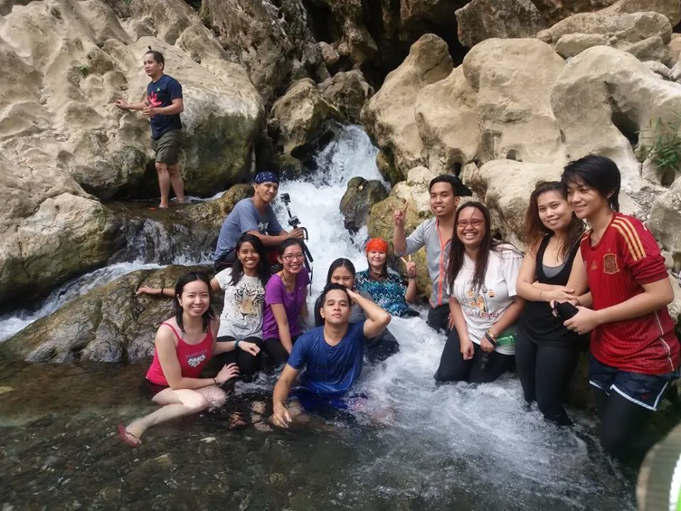
Tinipak River, located at the foot of Mount Daraitan, is an equally captivating destination, known for its crystal-clear waters and majestic limestone rock formations. The Mount Daraitan & Tinipak River combination has gained popularity not just for the physical challenge but also for the serene beauty that awaits at every turn. The river offers additional adventures, such as exploring the Tinipak Cave or taking a refreshing dip in its natural pools, enhancing the overall experience.
What sets the Mount Daraitan hike apart is the blend of natural beauty and cultural immersion. The local community in Barangay Daraitan plays a significant role in preserving the area’s pristine condition while promoting eco-tourism. Hikers are not just treated to the sights and sounds of nature but also to the warm hospitality of the locals, who share stories and traditions that add depth to the journey.
Table of Contents
Getting to Mount Daraitan
Location and How to get to Mount Daraitan
Mount Daraitan is located in Barangay Daraitan, a small village nestled within the Sierra Madre mountain range in Tanay, Rizal. This location has made the Mount Daraitan hike a popular escape for Manila-based adventurers looking for a quick yet rewarding outdoor experience. The proximity of Mount Daraitan to the capital city makes it an accessible destination, whether you’re planning a day hike or an overnight adventure.
To begin your journey, Barangay Daraitan serves as the primary jump-off point for the hike. The village is well-prepared to welcome hikers, with registration areas, guides, and amenities that cater to both seasoned and novice adventurers.
Getting to Mount Daraitan by Public Transportation: For those relying on public transport, the trip begins in Manila. The most common route involves taking a bus or van bound for Tanay, Rizal, which you can catch at several terminals such as the EDSA Central Terminal in Cubao or the Starmall in Shaw Boulevard. Once you arrive at the Tanay Public Market, the next step is to take a jeepney or tricycle to Barangay Daraitan. The tricycle ride takes approximately 30 to 45 minutes and leads you through scenic rural roads that gradually ascend into the mountains.
Upon reaching Barangay Daraitan, you’ll need to register and pay the necessary fees before starting your Mount Daraitan hike. The registration area is also where you can hire a guide, which is highly recommended, especially if it’s your first time.
Getting to Mount Daraitan by Private Vehicle: For those who prefer the comfort and convenience of a private vehicle, the journey from Manila to Mount Daraitan typically takes about 2 to 3 hours, depending on traffic conditions. The route follows Marcos Highway, passing through the towns of Antipolo and Teresa before reaching Tanay. From Tanay, follow the signs leading to Barangay Daraitan. The road becomes rougher as you approach the village, particularly the last few kilometers, which are unpaved and can be challenging for smaller vehicles.
Parking is available in Barangay Daraitan for a minimal fee, and from there, you can begin your hike. Driving directly to the jump-off point not only saves time but also allows for more flexibility in planning your itinerary.
Travel Tips and Costs: When planning your “Mount Daraitan hike,” it’s important to consider the costs involved in transportation and registration. Public transportation fares are generally affordable, with bus or van rides ranging from PHP 70 to PHP 100, and tricycle fares from Tanay to Barangay Daraitan costing around PHP 300 per ride. If you’re driving, be prepared for parking fees of about PHP 50 to PHP 100, depending on the duration of your stay.
Additionally, there are registration fees to be paid at the Barangay Daraitan office, including an environmental fee (around PHP 100) and a guide fee, which can range from PHP 500 for a day hike to PHP 1,250 for an overnight stay. These fees contribute to the maintenance of the trail and the support of the local community, ensuring that future hikers can continue to enjoy the beauty of Mount Daraitan and Tinipak River.
Whether you choose public transport or your own vehicle, getting to Mount Daraitan is part of the adventure. The journey through Tanay’s lush landscapes and up into the Sierra Madre mountains sets the stage for an unforgettable experience on the trail. With proper preparation and an understanding of the costs, your Mount Daraitan hike will be smooth and enjoyable from start to finish.

The Hike – What to Expect
Mount Daraitan Hike Experience
The Mount Daraitan hike is a thrilling and challenging adventure that takes you through some of the most stunning landscapes in Tanay, Rizal. As you begin your ascent from Barangay Daraitan, the trail quickly reveals its character—steep, rocky, and demanding, yet immensely rewarding for those who take on the challenge. The hike is known for its steep ascents, rocky paths, and the occasional sharp limestone formations that demand both physical and mental endurance.
The journey starts with a relatively gentle walk along a paved road, leading you deeper into the lush forest. However, the easy start soon gives way to the first major ascent, which is a true test of stamina. The trail becomes increasingly steep, with a mix of dirt and rocky paths that require careful footing. This part of the hike is a constant uphill battle, and hikers often describe it as a relentless assault on the legs.
Points of Interest Along the Trail: As you progress along the Mount Daraitan hike, you’ll encounter several notable landmarks that make the effort worthwhile. One of the first major points of interest is the Grotto of Mother Mary, a small shrine located along the trail. It’s a popular resting spot where hikers often pause to catch their breath, hydrate, and take in the serene atmosphere.
Further up the trail, after another challenging stretch, you’ll reach Heart Peak. This spot offers breathtaking views of the surrounding Sierra Madre mountains and the winding Tinipak River below. The panoramic vistas from Heart Peak provide a moment of respite, allowing hikers to appreciate the natural beauty that surrounds them. It’s also one of the most photographed spots on the hike, thanks to its dramatic scenery.
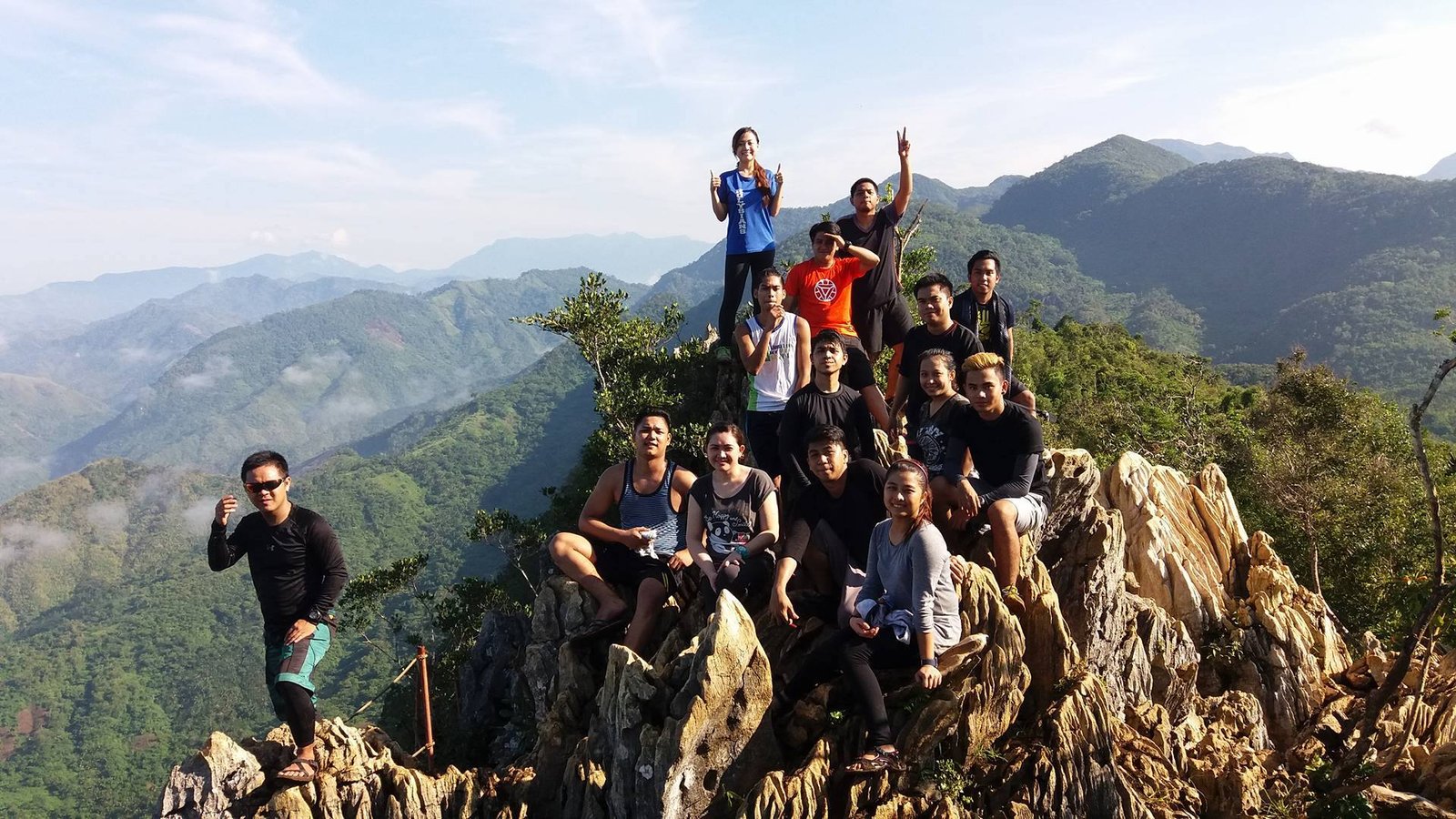
The final push to the summit of Mount Daraitan is perhaps the most demanding part of the hike. The trail here is steep and narrow, with jagged limestone rocks that require careful navigation. Reaching the summit, however, is a deeply satisfying experience. At 739 MASL, the summit offers stunning 360-degree views of the Sierra Madre mountain range, with the Tinipak River snaking through the valleys below. On clear days, you might even witness the breathtaking sea of clouds that occasionally forms around the peaks.
Proper Gear and Pace: Given the challenging nature of the Mount Daraitan hike, proper preparation is essential. It’s crucial to wear sturdy hiking shoes with good grip, as the rocky and often slippery paths can be treacherous, especially after rain. Gloves can also be useful for gripping the sharp limestone rocks along the trail.
Carrying enough water is vital, as the steep ascents can be exhausting, particularly under the sun. At least 2 liters per person is recommended, along with energy-boosting snacks like trail mix or fruit. A headlamp or flashlight is also necessary if you plan to start the hike early in the morning or descend after dark.
Pacing yourself is key to enjoying the hike. While the trail is demanding, it’s important to take regular breaks, especially at the Grotto of Mother Mary and Heart Peak, to rest and recharge. The hike to the summit typically takes 2-3 hours, depending on your pace and the weather conditions. It’s not a race, and taking your time to appreciate the surroundings will enhance the overall experience.
In summary, the Mount Daraitan hike is a challenging but incredibly rewarding experience, offering a mix of physical exertion and stunning natural beauty. From the steep ascents and rocky paths to the tranquil spots like the Grotto of Mother Mary and the scenic views from Heart Peak, every part of the trail has something unique to offer. Proper preparation and pacing are crucial to making the most of this adventure, ensuring that you reach the summit safely and enjoyably.

Reaching the Summit and Beyond
Upon reaching the summit of Mount Daraitan, hikers are rewarded with some of the most breathtaking panoramic views in the region. The summit offers an unrivaled vantage point to take in the expansive Sierra Madre mountain range, with its rolling peaks and verdant forests stretching as far as the eye can see. On clear days, the view is nothing short of spectacular, with the surrounding mountains creating a stunning backdrop against the blue sky.
One of the most iconic sights from the summit is the view of Tinipak River winding its way through the valleys below. The river’s crystal-clear waters and striking limestone rock formations are easily visible from this height, offering a glimpse of the next stage of your adventure. This combination of mountainous terrain and riverine beauty makes the “Mount Daraitan hike” particularly unique and memorable.
For those looking to capture the perfect photo, the summit provides several excellent spots. The limestone rock formations at the peak are not only great for framing stunning landscape shots but also serve as dramatic foreground elements for your photos. These jagged rocks, set against the backdrop of the Sierra Madre, make for striking images that are sure to impress.
Another popular photo opportunity is at Heart Peak, located just below the summit. This spot offers a slightly different angle of the landscape and is especially loved by hikers for its picturesque views of the river and mountains. Whether you’re an amateur photographer or just looking to snap some memorable shots for social media, the summit and Heart Peak are must-visit spots during your “Mount Daraitan hike.”
The Descent and the Traverse to Tinipak River
After soaking in the views and capturing your summit photos, the descent from Mount Daraitan begins. The route down is as challenging as the ascent, requiring careful attention to footing, especially on the steeper, rocky sections of the trail. However, the descent offers its own rewards, particularly if you opt for the traverse to Tinipak River—a route that is highly recommended for those seeking to experience the full spectrum of what this adventure has to offer.
The traverse takes you through a varied terrain, transitioning from the rugged, mountainous landscape to the serene river environment. As you make your way down, you’ll pass through dense forest areas where the sounds of nature—chirping birds, rustling leaves, and the distant rush of the river—create a calming atmosphere. This change in scenery is one of the highlights of the Mount Daraitan hike, as it showcases the diverse ecosystems within the area.
Upon reaching the Tinipak River, you’ll be greeted by a landscape dominated by towering limestone formations and clear, flowing water. The river itself is a haven for those looking to cool off after the strenuous hike. The crystal-clear waters of Tinipak River are perfect for a refreshing dip, while the surrounding rock formations provide plenty of spots to sit, relax, and enjoy the tranquility of the area.
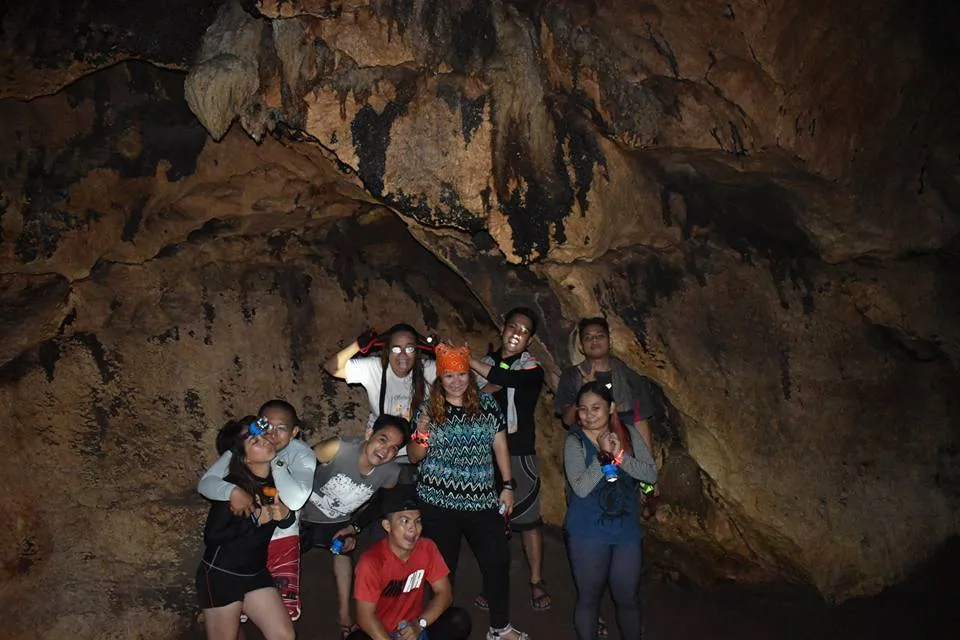
One of the key attractions along the river is the Tinipak Cave, located just a short trek from the riverbank. The cave features a natural pool inside, where you can take a swim while marveling at the cave’s stunning rock formations. This part of the “Mount Daraitan & Tinipak River” experience adds a layer of adventure and exploration that many hikers find particularly rewarding.
The descent and traverse to Tinipak River typically take about 2-3 hours, depending on your pace and how much time you spend at the river and cave. It’s a more relaxed part of the journey, offering plenty of opportunities to take in the beauty of the river landscape and reflect on the challenging but fulfilling hike you’ve just completed.
In conclusion, the descent from Mount Daraitan and the traverse to Tinipak River perfectly complement the more intense first half of the hike. By the time you reach the river, you’ll have experienced a full range of natural wonders, from the heights of the Sierra Madre mountains to the serene beauty of Tinipak River. This combination of mountain and river landscapes makes the Mount Daraitan hike an unforgettable adventure that truly has something for everyone.
Day Hike Itinerary for Mount Daraitan
Here’s a suggested itinerary for a day hike to Mount Daraitan, including the stunning Tinipak River. This plan will help you make the most of your adventure while ensuring you have ample time to enjoy the key spots along the trail.
02:00 AM – Departure from Manila
- Meet at a central location like Shaw Boulevard MRT Station in Mandaluyong. From there, you can take a van or a private vehicle heading to Tanay, Rizal. The travel time to Barangay Daraitan is approximately 2-3 hours.
05:00 AM – Arrival at Barangay Daraitan
- Upon arrival, you’ll need to cross the river via a bamboo raft (or bridge if available) and take a tricycle to the Barangay Hall. Here, you will register and secure a local guide (which is mandatory). This is also the time to grab a light breakfast if you haven’t eaten yet.
06:00 AM – Start of the Hike
- Begin your ascent to Mount Daraitan. The trail is moderately challenging, with steep sections that require careful navigation. The hike typically takes about 3-4 hours to reach the summit, depending on your pace and fitness level.
09:30 AM – Arrival at the Summit
- Upon reaching the summit, take in the breathtaking views of the Sierra Madre mountain range and the meandering Tinipak River below. This is a great time for photos, rest, and a quick snack.
10:30 AM – Start Descent to Tinipak River
- Begin the descent from the summit towards Tinipak River. The trail can be steep and slippery, so take your time. The descent usually takes about 2-3 hours.
12:30 PM – Arrival at Tinipak River
- Arrive at Tinipak River, where you can explore the area, including the nearby caves. The river is known for its clear, turquoise waters and impressive rock formations. Take a refreshing swim and enjoy your packed lunch by the river.
02:30 PM – Trek Back to Barangay Daraitan
- After enjoying the river, start the trek back to Barangay Daraitan. This part of the trek is relatively easy, following a riverside trail.
04:00 PM – Return to Barangay Hall
- Once back at Barangay Daraitan, freshen up and prepare for your return journey to Tanay. You can also take some time to explore the local community or buy souvenirs.
05:00 PM – Departure to Manila
- Head back to Tanay town proper, and from there, take a bus or van back to Manila. Expect to arrive in Manila by around 7:00 PM, concluding your day hike.
This itinerary ensures you experience the best of Mount Daraitan and Tinipak River in a single day, combining both adventure and relaxation

Practical Tips and Preparation
What to Bring and How to Prepare
Embarking on the “Mount Daraitan hike” requires careful preparation to ensure a safe and enjoyable experience. Here’s a comprehensive list of essentials you should pack and important tips to consider before you start your adventure.
Essential Items to Pack:
Water: Staying hydrated is crucial, especially given the strenuous nature of the hike. It’s recommended to bring at least 2 liters of water per person. There are no reliable water sources along the trail, so make sure you have enough to last the entire hike.
Snacks and Packed Lunch: Energy-boosting snacks like trail mix, fruits, and energy bars are ideal for quick refueling during the hike. If you plan to have lunch at the summit or along the trail, pack a light, easy-to-carry meal.
First Aid Kit: Accidents can happen on the trail, so it’s important to have a basic first aid kit that includes band-aids, antiseptic wipes, pain relievers, and any personal medication you might need.
Proper Footwear: The “Mount Daraitan hike” involves steep ascents and rocky paths, making it essential to wear sturdy hiking shoes with good grip. Proper footwear will help prevent slips and falls, especially on the sharp limestone rocks.
Clothing: Wear moisture-wicking clothing that dries quickly. Bring an extra set of clothes, especially if you plan to swim at Tinipak River. A lightweight jacket or raincoat is also advisable, as weather conditions can change rapidly.
Headlamp or Flashlight: If you plan to start the hike early in the morning or anticipate descending after dark, a headlamp or flashlight is essential for navigating the trail safely.
Gloves: Optional but recommended, especially if you need to use your hands to steady yourself on sharp or slippery rocks. Gloves can also protect your hands from cuts and scrapes.
Eco-friendly Items: Bring a reusable water bottle and a trash bag to ensure you adhere to the “leave no trace” principle. It’s important to minimize your impact on the environment during the hike.
Preparation Tips:
Conditioning: The “Mount Daraitan hike” is moderately challenging, with steep inclines and rugged terrain. It’s advisable to do some physical conditioning beforehand, such as cardio exercises and strength training, to prepare your body for the demands of the hike.
Weather Check: Before heading out, always check the weather forecast. The trail can become slippery and dangerous in wet conditions, so it’s best to plan your hike during clear weather. The dry season (November to May) is the most favorable time for hiking Mount Daraitan.
Eco-friendly Practices: As you hike, remember to stay on designated trails to minimize your impact on the environment. Avoid picking plants, disturbing wildlife, or leaving any litter behind. Supporting eco-tourism efforts helps preserve the beauty of Mount Daraitan and Tinipak River for future generations.
Local Fees and Supporting Guides: Upon arriving at Barangay Daraitan, you’ll need to pay several fees before starting your hike. These include an environmental fee (around PHP 100) and a registration fee (approximately PHP 30). Hiring a local guide is also recommended, with fees typically ranging from PHP 500 for a day hike to PHP 1,250 for an overnight stay.
Supporting local guides not only enhances your hiking experience with their knowledge and expertise but also contributes to the livelihood of the community. The guides are familiar with the terrain and can provide valuable insights into the local culture, flora, and fauna, making your “Mount Daraitan hike” more enriching.
By carefully preparing for your Mount Daraitan & Tinipak River adventure and following these practical tips, you’ll be well-equipped to tackle the challenges of the hike while fully enjoying the stunning natural beauty that awaits.
Additional Resources for Mount Daraitan
Planning a hike to Mount Daraitan requires proper preparation, including knowing the transportation options and contacting local tourism offices for guidance. Below are some valuable resources to help you plan your adventure.
Links to Useful Websites:
Tourism and Hiking Information:
- Tanay Tourism Office: Offers information on Mount Daraitan, nearby attractions, and how to arrange local guides.
Contact Information:
For more detailed and specific inquiries, contacting local tourism offices and guide services is recommended:
Tanay Municipal Tourism Office:
- Address: Municipal Hall, Tanay, Rizal, Philippines
- Phone: +63 2 8656 6462
- Email: tanaytourismoffice@gmail.com
Mount Daraitan Local Guide Coordination:
- Phone: +63 935 633 7731 (Local guide service)
These resources will help ensure a safe and enjoyable hike to Mount Daraitan, one of Rizal’s most popular outdoor destinations.

Conclusion
Why You Should Hike Mount Daraitan and Visit Tinipak River
The Mount Daraitan hike offers a perfect blend of physical challenge, breathtaking natural beauty, and rich cultural experiences, making it one of the most rewarding adventures near Metro Manila. The hike’s moderately challenging trail takes you through steep ascents and rocky paths, leading to a summit that provides panoramic views of the Sierra Madre mountains and the serene Tinipak River below. This unique combination of rugged terrain and stunning scenery is what makes the Mount Daraitan & Tinipak River experience so special.
Beyond the physical rewards, the hike also offers an opportunity to immerse yourself in the local culture. The warm hospitality of Barangay Daraitan’s residents, coupled with their dedication to preserving the environment, adds a layer of cultural enrichment to your journey. Whether you’re an experienced hiker seeking a new challenge or a nature lover looking for a peaceful retreat, the Mount Daraitan hike, with its picturesque trails and the tranquil beauty of Tinipak River, is a must-visit destination.
Embarking on this adventure promises not just a fulfilling outdoor experience but also a deeper appreciation of the natural and cultural heritage of Rizal province. The “Mount Daraitan hike” is more than just a trek; it’s a journey that connects you with the land, its people, and the enduring beauty of nature.
Have you experienced the Mount Daraitan hike or visited Tinipak River? Share your stories and tips in the comments section below—we’d love to hear from you! If you have any questions or need further information, feel free to ask.
For more travel guides, hiking adventures, and tips on exploring the best of the outdoors, don’t forget to subscribe to our blog. Follow us on social media to stay updated with our latest adventures and get inspired for your next trip. Let’s explore the world, one trail at a time!
FAQ: Mount Daraitan Hike
1. How difficult is the Mount Daraitan hike? The Mount Daraitan hike is considered moderately challenging, with a difficulty rating of 4/9. The trail includes steep ascents, rocky paths, and sharp limestone formations, which can be demanding, especially for beginners. The hike typically takes 3-4 hours to reach the summit, depending on your pace and the weather conditions.
2. What are the fees associated with the Mount Daraitan hike? When you arrive at Barangay Daraitan, you will need to pay several fees. These include a Barangay fee of PHP 20 per person, an Environmental fee of PHP 100, and a Guide fee, which ranges from PHP 500 for a day hike to PHP 1,250 for an overnight stay. If you are bringing a private vehicle, parking fees range from PHP 50 to PHP 100 .
3. What should I bring for the hike? It is essential to pack the right gear for the Mount Daraitan hike. Bring at least 2 liters of water, energy-boosting snacks, a first aid kit, and proper hiking footwear with good grip. Other useful items include a headlamp or flashlight, gloves, a lightweight raincoat, and eco-friendly items like a reusable water bottle and trash bag to adhere to the “leave no trace” principle.
4. How do I get to Mount Daraitan from Manila? To get to Mount Daraitan from Manila, you can either use public transportation or drive. If using public transport, take a bus or van from Cubao or Shaw Boulevard to Tanay, Rizal. From Tanay, take a jeepney or tricycle to Barangay Daraitan, which is the jump-off point for the hike. If driving, follow Marcos Highway through Antipolo and Tanay, and then proceed to Barangay Daraitan.
5. Can I swim in Tinipak River after the hike? Yes, swimming in Tinipak River is one of the highlights of the Mount Daraitan hike. The river, with its clear waters and impressive limestone formations, is a perfect spot to cool off after the challenging hike. There are also opportunities to explore Tinipak Cave, which features a natural pool ins.

Pingback: The Ultimate Guide To The Top 10 Mountains In The Philippine – BizBackLinks