Mt. Arayat Profile: The Quick Specs
The hike to Mt. Arayat is a Major Climb with a difficulty rating of 5/9 for the standard Traverse and up to 7/9 for the “Quad Peak” route. A full traverse takes 10-12 hours to complete, featuring technical rock scrambling on the “Monkey Trail” and a steep descent on slippery red soil. Unlike minor hikes near Manila, this requires significant endurance due to the intense “thermal trap” heat in Pampanga.
The Solitary Sentinel of Central Luzon
While many hikers flock to the Cordilleras for the cold, Mt. Arayat offers a different beast entirely: a “thermal trap” that tests your heat tolerance as much as your legs. Rising in geological isolation to 1,026 Meters Above Sea Level (MASL), this extinct stratovolcano does not share its weather with a range; it absorbs the full humidity of the Central Luzon plains. The mountain is defined by its “Twin Peaks”—the North Peak (1,030 MASL) in Magalang, Pampanga, and the South Peak (1,008 MASL) in Arayat Town.
Connecting these two summits is the notorious “saddle,” a jagged ridgeline often called the Monkey Trail. This section is what separates Mt. Arayat from beginner-friendly day hikes like Mt. Batulao. The terrain shifts rapidly from the loamy “Agricultural Apron” full of tomato and okra crops at the base, to a dense Dipterocarp forest, and finally to technical rock scrambling at Haring Bato (King’s Rock).
Quick Hike Statistics (2026 Data)
| Feature | Specification |
| Highest Point | 1,030 MASL (North Peak, Magalang) |
| Difficulty Level | Major Climb (5/9 Traverse |
| Trail Class | 1-4 (Forest, Rock Scrambling, Roped Segments) |
| Hiking Time | 10 – 12 Hours (Standard Traverse) |
| Limatik Presence | None (Confirmed Negative 2026) |
| Phone Signal | Intermittent (Strongest at North Peak Outpost) |
The “LakbayPinas” Insider Experience
In my years of climbing, I’ve seen more hikers tap out here due to dehydration than fatigue. Because Mt. Arayat stands alone, it blocks the prevailing winds, creating a microclimate where the heat feels “stuck” at the base.
The “Red Soil” Hazard: The descent from the South Peak to Brgy. San Juan Baño is famous for its reddish clay soil. Even if it hasn’t rained in days, the morning dew can turn this into a grease-like slide. I highly recommend using trekking poles here to save your knees.
Water Discipline: There are zero water sources from the forest line up to the summit. When I guide groups here, I enforce a strict “3-Liter Rule” per person at the jump-off. Do not rely on finding water on the trail.
E-E-A-T Note: The view from the South Peak view deck offers the classic “Snake View” of the Pampanga River, but the North Peak offers a safer, wider camping ground next to the police outpost.
Table of Contents

Pre-Climb Requirements (Bureaucracy)
As of 2026, a medical certificate is not strictly mandatory for Mt. Arayat, unlike Mt. Pulag. However, all hikers must sign a Liability Waiver and Health Declaration Form at the jump-off point. Walk-ins are generally allowed, but large groups should coordinate with the Magalang Tourism Office or Arayat National Park. Prepare small bills for the registration fees ranging from ₱50 to ₱100.
Permits & Registration Logistics
The registration process depends on your chosen entry point. For the Traverse, you will register at the entry in Brgy. Ayala, Magalang, and pay an exit fee at Brgy. San Juan Baño, Arayat.
-
Magalang Entry (North Peak/Traverse Start): The registration area is located at the barangay outpost, just before the “Stations of the Cross” concrete road. In my experience, the fee here is often a “donation” or a fixed ₱50 – ₱100 Environmental Fee.
-
Arayat Entry (South Peak/Traverse Exit): If you are doing a backtrail or exiting here, you will pass through the Arayat National Park (DENR Station). The entrance fee is fixed at ₱75 – ₱100, which includes access to the resort premises.
The Medical Certificate Question
While the Local Government Units (LGUs) of Magalang and Arayat do not currently demand a “Fit to Climb” certificate, I strongly advise against taking this lightly. Mt. Arayat requirements now include a strict Health Declaration Form due to the high incidence of heat exhaustion on the trail. If you have a history of hypertension, bring a clearance from your doctor; the initial assault is an immediate cardio test.
Emergency & Coordinator Contact Numbers
Save these numbers before you lose signal in the dipterocarp forest. The North Peak is manned by a permanent PNP/Military outpost, making it one of the most secure summits in Luzon.
-
PNP / Emergency Response: 0906-291-6662 (Globe) / 0998-598-5450 (Smart)
-
Magalang Tourism (Ryan Miranda): 0927-717-3130 (Verify active status prior to trip)
-
Arayat Registration (Marlon Nucup): 0936-811-1323 (For San Juan Baño side)
LakbayPinas Tip: Do not be alarmed by the soldiers stationed at the summit. They are friendly to hikers and often have the best weather updates. I usually offer them a small snack or cold drink if I have extras—it’s a small gesture of thanks for their watch.
How to Go to Mt. Arayat (DIY Logistics)
To commute to Mt. Arayat from Manila, take a Victory Liner or Genesis bus bound for San Fernando (SM Pampanga) or Dau Terminal (₱180 – ₱250). From the San Fernando intersection, board a jeepney to Magalang Town Plaza (for Traverse Entry) or Arayat Town (for South Peak/Exit). Finally, hire a tricycle to the Brgy. Ayala or San Juan Baño jump-off point (₱100 – ₱150 per ride).
Step 1: Manila to Pampanga Hubs
The most efficient route starts at the bus terminals in Cubao or Pasay. Board a bus operated by Victory Liner, Genesis, or Bataan Transit bound for San Fernando, Pampanga or Dau. I personally prefer dropping off at the San Fernando Intersection (specifically near SM Pampanga or Robinson’s Starmills) because it serves as the central hub for both Magalang and Arayat jeepneys.
-
Fare: ₱180 – ₱220 (AC Bus)
-
Travel Time: 1.5 – 2.0 Hours (allocate more time if leaving during rush hour)
Step 2: The “Gap” Transfer (Jeepney)
Once you arrive at SM Pampanga, you need to choose your route based on your hike plan. This is critical for the Mt. Arayat DIY guide:
-
For Traverse / North Peak (Entry): Take a modern jeep or traditional jeepney to Magalang Town Proper. The terminal is usually at the transport bay of SM Pampanga.
-
Fare: ₱45 – ₱60
-
Travel Time: 45 Minutes
-
-
For South Peak (Backtrail): Take a jeepney bound for Arayat Town Proper.
-
Fare: ₱50 – ₱65
-
Travel Time: 45 – 60 Minutes
-
LakbayPinas Insider Tip: If you are a large group (10+ pax), I suggest negotiating a “special trip” or chartered jeepney directly from San Fernando to the Brgy. Ayala jump-off. We usually pay around ₱800 – ₱1,200 for the whole jeep. It saves you the hassle of transferring to a tricycle later.
Step 3: The “Last Mile” (Tricycle)
From the town proper, the final leg is a tricycle ride to the registration area.
-
Magalang Side: From the Magalang Town Plaza, hire a tricycle to Brgy. Ayala (tell the driver “Station of the Cross” or “Abe’s Farm”).
-
Rate: ₱100 – ₱150 per ride (Good for 3-4 pax).
-
-
Arayat Side: From Arayat Town Plaza, hire a tricycle to Brgy. San Juan Baño (tell the driver “National Park” or “Resort”).
-
Rate: ₱100 – ₱150 per ride.
-
Private Vehicle Navigation
If you are driving, the NLEX (North Luzon Expressway) is your main artery. Waze is generally reliable here.
-
To Magalang (Traverse Start): Take the Angeles Exit or Dau Exit. Follow the Magalang-Angeles Road until you reach the Municipal Hall, then turn right to Brgy. Ayala.
-
To Arayat (South Peak): Take the Mexico Exit or San Fernando Exit. Follow the Jose Abad Santos Avenue (Olongapo-Gapan Road) eastward.
-
Parking Security: Both jump-offs offer secure parking. In Brgy. Ayala, you can park near the barangay outpost or the start of the Stations of the Cross for ₱50 – ₱100. In San Juan Baño, the Arayat National Park has a gated compound.

The Trail Analysis & Camp Features
The Mt. Arayat trail is defined by three distinct sectors: the steep “Stations of the Cross” warm-up in Magalang, the technical “Monkey Trail” ridge featuring rock scrambling between the twin peaks, and the slippery “Red Soil” descent in Arayat. Note that there are zero water sources on the upper trail, requiring a strict 3-Liter minimum carry. Mobile signal is available but intermittent near the summit outposts.
Sector 1: The Ascent (Magalang & The Stations)
The trek begins at Brgy. Ayala with a deceptive start. You will hike up a concrete road lined with the 14 Stations of the Cross. Don’t let the pavement fool you; the consistent gradient here is a mental and physical filter. By the time you pass the final station and enter the Dipterocarp Forest, the heat is already stifling. The trail then transitions into the “Woodland Wall,” a steep Class 3 ascent on loam and roots that leads directly to the North Peak (1,030 MASL).
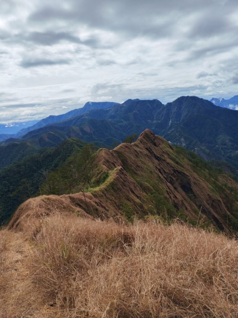
Sector 2: The “Monkey Trail” (Ridge Crossing)
This is the heart of the Mt. Arayat Traverse. Connecting the North Peak to the South Peak is a jagged ridgeline that requires technical scrambling. You will encounter Haring Bato (King’s Rock), a massive volcanic boulder blocking the path.
Technicality: This section often requires “3-point contact” (using both hands and feet).
Safety: Ropes are installed in the most vertical sections, but I always wear gloves here to protect against sharp volcanic rock and thorny rattan vines hidden in the brush.
Sector 3: The “Red Soil” Descent (Arayat Side)
After enjoying the “Snake View” of the Pampanga River at the South Peak (1,008 MASL), the descent to San Juan Baño presents a unique hazard. The trail is composed of reddish clay that becomes notoriously slippery—like grease—when wet, and dusty powder when dry. Even with aggressive trail runners, I have slipped here multiple times. The trail eventually exits the forest into the Agricultural Apron, passing through tomato and okra fields where the sun exposure is brutal.
Water, Wash-up, and Connectivity
Water Source: CRITICAL WARNING. There are no water sources established from the jump-off to the summit. Unlike Mt. Pulag or Tapulao, you cannot refill here. I strictly enforce a 3-Liter Rule (2.5L for hydration, 0.5L for emergency) for every hiker in my team.
Wash-up Facilities: The exit at Arayat National Park offers the best recovery option: natural spring swimming pools. You can pay the ₱75 entrance fee to shower and cool down immediately after the hike.
Phone Signal: Signal for Smart and Globe is intermittent along the trail but becomes strong/usable near the North Peak Police Outpost and the South Peak View Deck.

Mt. Arayat Itinerary Options (2026)
A standard Mt. Arayat Traverse day hike takes between 10 to 12 hours to complete depending on the group’s pace on the technical sections. To avoid the punishing midday heat and navigate the “Monkey Trail” safely, I strongly recommend an “Alpine Start” of 2:00 AM or 3:00 AM. If you have not reached the North Peak by 11:00 AM, it is safer to abort the traverse.
Option A: The Classic Traverse (Magalang to Arayat)
This is the most popular and logical route for a Mt. Arayat itinerary. By starting in Magalang, you tackle the hardest elevation gain early in the morning while your legs are fresh. You then cross the ridge and descend via Arayat, ending your hike directly at the San Juan Baño resort for a celebratory swim.
| Time | Activity | Elevation / Logistics |
| 01:00 AM | ETD Manila (Cubao/Pasay) | Private Van Recommended |
| 04:30 AM | Arrival at Brgy. Ayala, Magalang | Register / Warm-up |
| 05:00 AM | Start Trek (Stations of the Cross) | Paved but steep warm-up |
| 09:00 AM | Arrival at North Peak (Peak 1) | 1,030 MASL / Breakfast |
| 09:30 AM | Start “Monkey Trail” Traverse | Rope segments & rock scrambling |
| 11:00 AM | Cross Haring Bato (King’s Rock) | Technical Section |
| 12:30 PM | Arrival at South Peak (Peak 2) | 1,008 MASL / Lunch @ View Deck |
| 01:30 PM | Start Descent (Red Soil Trail) | Strictly adhere to 3L water rule |
| 04:30 PM | Exit at San Juan Baño (Resort) | Pay ₱75 fee / Swim & Wash-up |
| 06:00 PM | Dinner at San Fernando | Try Cely’s Carinderia |
| 09:00 PM | ETA Manila | Home Sweet Home |
LakbayPinas Insider Tip: The timeline above assumes a moderate pace. The “Monkey Trail” is a bottleneck. If you are stuck behind a large group at Haring Bato, expect delays. I always tell my joiners: “Speed on the ascent buys you time on the ridge.”
Option B: The “Quad Peak” Extension (Expert Only)
For those who find the standard traverse too easy, the Quad Peak route includes the Pinnacle and Peak 3. This extends the hike to 14 hours and requires highly technical maneuvering around sharp volcanic rocks.
Note: This is strictly for advanced hikers. Do not attempt this if it is your first time in Pampanga. You must specifically request a “Quad Peak” qualified guide from the association, as not all guides traverse this jagged section. The difficulty spikes to 7/9.

Budget Breakdown (The Financials)
As of 2026, the standard guide fee for the Mt. Arayat Traverse is ₱1,800 to ₱2,500 for a group of 5 hikers. For the more technical “Quad Peak” route, expect to pay around ₱3,500. Registration fees are decentralized; prepare to pay separate environmental fees in Magalang (₱50-₱100) and entrance fees at the Arayat National Park resort (₱75-₱100).
The “Safe Budget” for DIY Hikers
Many hikers underestimate the cost of Mt. Arayat because it is a day hike. However, the multi-modal transport (Bus + Jeep + Trike) adds up quickly. Below is a realistic Mt. Arayat hiking budget for a DIY solo traveler joining a group of 5 to share the guide fee.
| Line Item | Estimated Cost (PHP) | Notes |
| Bus Fare (Roundtrip) | ₱400 – ₱500 | Cubao ↔ San Fernando (Victory/Genesis) |
| Jeepney Transfers | ₱100 – ₱130 | San Fernando ↔ Magalang/Arayat |
| Tricycle Rides | ₱100 – ₱150 | “Last Mile” share (assuming 3-4 pax/trike) |
| Registration / Env. Fee | ₱50 – ₱100 | Collected at Brgy. Ayala outpost |
| Resort/Exit Fee | ₱75 – ₱100 | Arayat National Park (Mandatory for exit) |
| Guide Fee (Shared) | ₱360 – ₱500 | Based on ₱1,800 – ₱2,500 rate (1:5 Ratio) |
| Food / Recovery Meal | ₱300 – ₱500 | Post-hike Sisig at Cely’s or Abe’s Farm |
| SAFE TOTAL | ₱1,500 – ₱2,000 | Excludes Porter fees |
Understanding the Fees
The financial landscape here is decentralized. Unlike centralized parks where you pay one fee, Mt. Arayat involves two different municipalities.
The Guide Fee Reality: You might wonder why the fee (₱1,800+) is higher than other day hikes. This is because the Traverse covers two towns. The guide has to pay for their own transportation to get back to their origin point (e.g., from Arayat back to Magalang) after they drop you off.
Porter Fees: If you are carrying heavy photography gear or drone equipment, I highly recommend hiring a porter. The rate is usually ₱1,500 – ₱2,000 due to the technical nature of the Monkey Trail.
LakbayPinas Insider Tip: If you drive a private car and park at Brgy. Ayala (Magalang), remember that you will exit at Arayat. You must budget for a tricycle ride (approx. ₱500 – ₱600 for the special trip) to take you back to your car in Magalang. To save money, my group usually leaves the car at San Fernando (SM Pampanga) and just commutes the final leg so we don’t have to backtrack.

Where to Eat & Post-Climb Recovery
For a premium recovery meal, Abe’s Farm in Magalang offers authentic Kapampangan dishes like Binukadkad na Pla-Pla right at the foothills. For budget-friendly authentic options, Cely’s Carinderia in San Fernando is a pilgrimage site for the original Sisig, or try local eateries in Magalang town proper for Pindang Damulag (Carabao Tocino).
The Culinary Capital Reward
You cannot climb in Pampanga without indulging in the “Culinary Capital of the Philippines.” After burning 2,000+ calories on the Mt. Arayat Traverse, your body will demand protein and salt.
The Premium Choice (Magalang): If you parked your car at Brgy. Ayala, the most convenient stop is Abe’s Farm. It’s a lifestyle destination nestled in the foothills. I highly recommend their Pako Salad (fiddlehead fern) and Bamboo Rice. Expect to spend ₱500 – ₱800 per head.
The Commuter’s Choice (San Fernando): If you are taking the bus back to Manila, make a pit stop at Cely’s Carinderia near the San Fernando Intersection. Their Sisig and Morcon are legendary among mountaineers. A hearty meal here costs only ₱150 – ₱250.
LakbayPinas Insider Tip: If you are eating in Magalang Town Proper, ask for Pindang Damulag (cured Carabao meat). It has a unique sour-salty profile that pairs perfectly with garlic rice. It’s an acquired taste, but it’s the fuel of local farmers.
The “Banyo” Benefit (Arayat Exit)
The defining feature of the Mt. Arayat itinerary is the exit point at Brgy. San Juan Baño. Unlike other mountains where you wash up in a cramped makeshift cubicle, the exit here is inside the Arayat National Park Resort.
Recovery Swim: The park features multiple swimming pools fed by cool, natural spring water from the mountain.
Logistics: The entrance fee is usually included in your exit payment (₱75 – ₱100).
Why it matters: After descending the “Red Soil” trail, you will be covered in fine red dust. Plunging into these cold springs is the ultimate morale booster before the long trip back to Manila.
The “Fear Factor” Challenge
For the adventurous eaters in the group, look for roadside stalls or specialized canteens serving Betute (stuffed frog) or Camaru (mole crickets). It’s a rite of passage for first-time visitors to Central Luzon.

What to Bring (The Arayat Gear List)
When packing for Mt. Arayat, prioritize carrying 3 to 4 Liters of water because there are absolutely no water sources on the ridge. Wear trail running shoes with aggressive lugs to handle the slippery red clay of the South Peak descent. Gloves are essential for the sharp volcanic rocks on the “Monkey Trail,” and trekking poles are highly recommended to save your knees.
Essential Gear for the “Thermal Trap”
The gear you bring to Mt. Arayat differs from a typical Cordillera hike because you are battling heat, not cold. The 1,026 MASL elevation does not guarantee cool air; the humidity in the Magalang forest line is intense.
-
Hydration System (Critical): I cannot stress this enough—bring 2 Liters minimum. I personally carry a 2L bladder and a 1L Nalgene bottle with electrolyte powder (e.g., Gatorade or Pocari Sweat sachets) to prevent cramps during the steep assault.
-
Footwear Strategy: Leave the heavy boots at home. I use trail runners like Salomon Speedcross or Hoka Speedgoat because their lugs bite into the loose soil better. Flat-soled sneakers are dangerous on the “Red Soil” slide descending to San Juan Baño.
-
Hand Protection: The Monkey Trail requires you to hold onto rocks and sometimes thorny vines. A pair of cheap garden gloves or mechanic gloves (available at hardware stores for ₱50) will save your hands from cuts.
The “LakbayPinas” Packing Checklist
Here is the specific loadout I use for a Mt. Arayat Traverse day hike:
-
Sun Protection: A wide-brimmed hat or cap is vital for the exposed “Agricultural Apron” at the end of the hike (past 3:00 PM).
-
Trekking Poles: Essential for the descent. It takes the load off your knees on the slippery clay steps near the South Peak.
-
Emergency Kit: Whistle, Headlamp (in case you get delayed past sunset), and a basic First Aid Kit with betadine and antihistamine (for insect bites).
-
Clothing: Wear Drifit or synthetic materials. Avoid cotton—it gets heavy with sweat and won’t dry in the humid forest.
-
Recovery Gear: Bring a full set of extra clothes and a towel. You will need these for the ₱75 shower or swim at the Arayat National Park resort after the climb.
-
Cash: Bring small bills (₱20, ₱50, ₱100) for the tricycle transfer and registration fees.
LakbayPinas Insider Tip: While there are no limatiks (leeches) here, the mosquitoes in the lower Dipterocarp Forest are aggressive. I spray my clothes with Permethrin beforehand or apply a high-DEET insect repellent at the jump-off in Brgy. Ayala.
Frequently Asked Questions (FAQ)
Mt. Arayat is generally not considered beginner-friendly, especially the Traverse route which is rated 5/9 difficulty. However, fit beginners can attempt the North Peak Backtrail (Magalang side) as a “test hike.” Guides are mandatory for all routes to ensure safety on the technical ridge. There are no Limatiks (leeches) present on the mountain.
Q: Is Mt. Arayat beginner-friendly?
No. I always tell aspiring hikers that the Mt. Arayat Traverse is a “Major Climb” disguised as a day hike. The difficulty lies in the sustained steepness of the Magalang assault and the technical rock scrambling on the Monkey Trail.
Alternative: If you are a beginner set on climbing it, opt for the North Peak Backtrail (Up and down via Brgy. Ayala). It avoids the technical ridge but still offers the summit view at 1,030 MASL.
Q: Are there Limatiks (leeches) in Mt. Arayat?
No. Unlike Mt. Makiling or Mt. Halcon, Mt. Arayat is confirmed to be Limatik-free as of 2026. You do not need to wear leech socks. However, watch out for large red ants and mosquitoes in the lower Dipterocarp Forest near the “Stations of the Cross.”
Q: Is it safe for solo female hikers?
Yes. The trail is heavily regulated with a mandatory 1:5 Guide Ratio. You will never be hiking truly “alone.” Furthermore, the permanent presence of a PNP/Military Outpost at the North Peak provides a unique layer of security that other mountains lack.
Insider Note: The soldiers are friendly and often share water or coffee if you strike up a conversation.
Q: Can we hike at night?
Alpine starts at 2:00 AM or 3:00 AM are standard practice to beat the heat. However, night trekking the ridge (Monkey Trail) is strongly discouraged. The path is narrow, bordered by cliffs, and filled with thorny rattan.
Rule of Thumb: If you haven’t reached the North Peak by 11:00 AM, your guide will likely advise aborting the traverse to ensure you don’t get caught on the ridge after sunset.
Q: Do I need to book in advance?
For small groups (1-5 pax), walk-ins are accepted at Brgy. Ayala (Magalang) and Brgy. San Juan Baño (Arayat). However, for large caravans or during peak season (Holy Week), it is best to message the Magalang Tourism Office ahead of time to secure enough guides.
Conclusion
The Mt. Arayat Traverse is a definitive test of endurance, rated 5/9 difficulty due to its intense heat and technical ridge. Completing this 10-12 hour trek requires serious preparation, specifically a 3-Liter water carry and an alpine start to beat the midday sun. It stands as one of the most rewarding—and demanding—day hikes in Central Luzon.
A Test of Character
In my years of exploring Pampanga, I have learned that Mt. Arayat is a mountain that demands humility. It may look accessible from the NLEX, but the 1,030 MASL ascent is a “thermal trap” that filters out the unprepared. The transition from the humid Dipterocarp Forest to the jagged Monkey Trail tests not just your legs, but your patience and focus. It is a true mountaineer’s climb disguised as a day trip.
Leave No Trace (LNT) Principles
Because the ridge is narrow and hazardous, clean-up operations are difficult for the local guides. Please practice strict LNT to preserve the domain of Mariang Sinukuan.
Pack it in, Pack it out: Do not leave energy gel wrappers or plastic bottles on the Haring Bato rocks.
Noise Discipline: Respect the silence of the forest; sound travels far in the saddle.
Dispose Responsibly: Bring all your trash down to the bins at the San Juan Baño resort exit.
Ready for the Twin Peaks?
Are you ready to face the challenge? Book your guide at Brgy. Ayala, pack your mandatory 3 Liters of water, and prepare for one of the best climbs near Manila. Whether you end your day with a refreshing swim at the Arayat National Park or a sizzling plate of Sisig at Cely’s Carinderia, the pain of the assault is always worth the reward.
Explore More Major Climbs in Luzon
If you are ready to tackle the heat and technical ridges of Mt. Arayat, you might be looking for your next endurance test. Check out our other comprehensive guides for major climbs in the region:
The 36km Endurance Test: Ready for a longer battle? Mt. Tapulao Travel Guide: Surviving the 36km Challenge in Zambales offers a pine forest experience with a punishing rocky road that rivals Arayat’s difficulty.
The Pine Forest Traverse: If you prefer cool winds over Arayat’s humidity, head north for the Guide to Mt. Ugo Traverse (Nueva Vizcaya). It’s a scenic alternative with established campsites.
Compare Your Climb: Wondering how Arayat ranks against other giants? Read our list of Major Climb Mountains in the Philippines (Difficulty 5/9 – 8/9) to find your next target.
The “Maktrav” Alternative: If you want a similar tropical forest challenge (but with Limatiks!), read our Guide to Mt. Makiling 2025 (UPLB Trail & Maktrav). It’s the closest technical equivalent to Arayat near Manila.