Introduction – Why Chase the Sea of Clouds in Tanay?
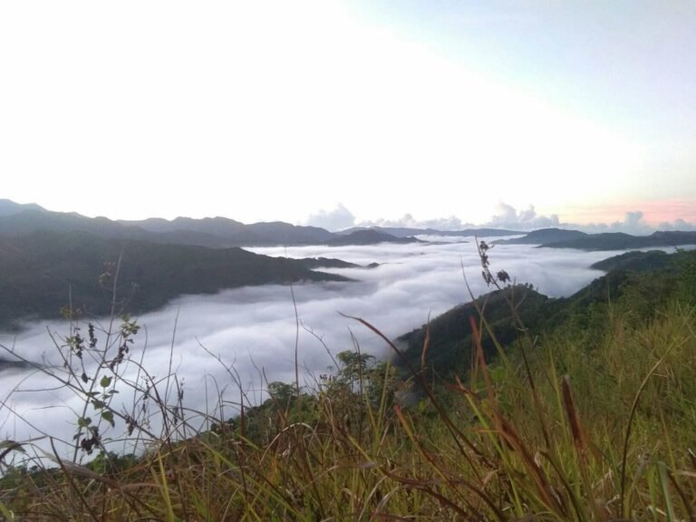
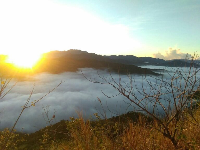
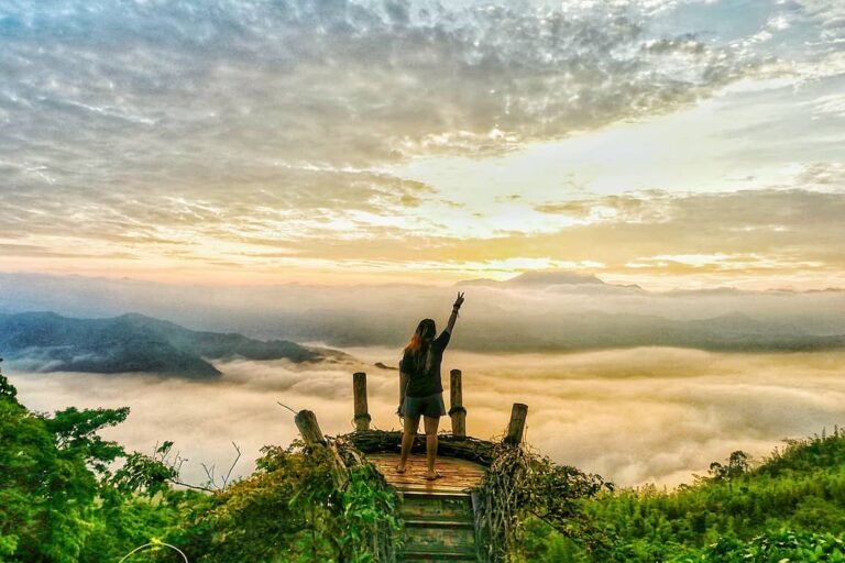
The first time I witnessed the sea of clouds in Tanay Rizal, I was standing on a grassy ridge just before sunrise. The chilly air brushed against my face, and as the horizon began to glow orange, a thick blanket of white slowly rolled in, covering the valleys below. From above, the peaks of the Sierra Madre looked like tiny islands floating in an endless ocean of mist. It was a scene that photographs could never fully capture—a moment that made me understand why so many travelers wake up at 2:00 a.m. just to experience this magical sight.
Tanay, a municipality in Rizal province, sits on the western flank of the Sierra Madre mountain range, the longest in the Philippines. Because of its elevation and lush terrain, it has become one of the most accessible gateways for adventure and nature escapades near Metro Manila. Only two to three hours away from the capital, Tanay is a popular weekend destination for hikers, campers, and families seeking both fresh air and breathtaking landscapes. Among its many attractions, the Tanay sea of clouds phenomenon stands out as the most sought-after experience.
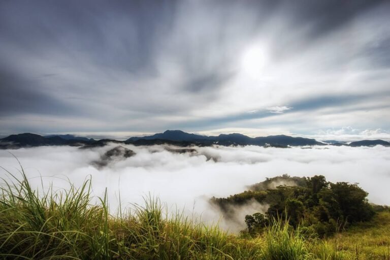
What makes this natural wonder special is that it’s both beautiful and fleeting. The sea of clouds in Tanay appears only under specific weather conditions: cool mornings, high humidity, and clear skies right before sunrise. That’s why even though places like the Treasure Mountain sea of clouds are famous for being “no-hike” viewing decks, locals and seasoned mountaineers alike will tell you that patience and timing are part of the adventure. Some mornings, the view is crystal clear, revealing Taal Volcano, Mt. Banahaw, or Laguna de Bay. Other days, you may be surrounded by fog, only for the clouds to part dramatically minutes later, revealing the rolling peaks of Rizal.
As a travel blogger who has visited Tanay multiple times, I can attest that this phenomenon isn’t just about the visual spectacle—it’s about the journey. Whether you hike Mt. Daraitan for hours, take a quick trek to Mt. Kulis, or drive straight up to Treasure Mountain, every trail and campsite teaches you to respect nature and embrace the unpredictability of the outdoors.
In the sections ahead, I’ll share the 10 must-visit mountains in Tanay for sea-of-clouds chasers. This guide combines firsthand experience, verified local information, and practical travel tips to help you plan a safe, memorable, and responsible trip to one of Rizal’s crown jewels.
Table of Contents
10) Mt. Lilid
Often overshadowed by its more popular neighbor Mt. Tinucan, Mt. Lilid is a hidden gem in Tanay that deserves more recognition. Rising at around 556 MASL, this peak forms part of the Tinucan Circuit, making it a natural extension for hikers who want to maximize their trip. While less commercialized, Lilid offers the same breathtaking landscapes and the chance to witness the sea of clouds in Tanay Rizal—but without the larger crowds.
Trail and Hiking Experience
The trek to Mt. Lilid usually begins after summiting Mt. Tinucan. From the Tinucan summit, hikers follow a ridge trail that descends slightly before climbing back up to Lilid. The trail is raw and less maintained, so expect overgrown sections, uneven ground, and grassy slopes that can be slippery after rain. The hike from Tinucan to Lilid takes about 30 minutes to 1 hour, making it an easy add-on for those who want a more complete adventure. Because of the unmarked paths, hiring a local guide is highly recommended.
Fees and Local Requirements
There are no separate fees for Mt. Lilid; hikers simply pay the standard registration fee (₱40–₱50) at the Tinucan barangay hall. A guide fee of ₱500 per group covers both Tinucan and Lilid, making the circuit an affordable option for budget-conscious hikers.
Best Time for Sea of Clouds
Like Tinucan, Mt. Lilid offers its best views at sunrise during the cool months (November to March). The ridges provide wide, open vantage points to watch the Tanay sea of clouds drift across the valleys. On clear days, you may even catch glimpses of Laguna de Bay and neighboring Sierra Madre peaks.
Practical Tips
Combine Tinucan and Lilid in a single trip for a half-day adventure.
Wear long pants and sleeves—the trail is brushy and can cause scratches.
Bring a hat and sunscreen, as much of the trail is exposed.
If you’re new to the area, don’t attempt Lilid without a guide—trails can be confusing.
Quiet, scenic, and beginner-friendly, Mt. Lilid is proof that even Tanay’s lesser-known mountains can deliver unforgettable sea of clouds in Tanay Rizal experiences.
9) Mt. Tinucan
If you’re looking for a beginner-friendly climb that still rewards you with the classic sea of clouds in Tanay Rizal, Mt. Tinucan is a solid choice. Rising at 591 MASL, this grassy peak in Brgy. Tinucan is ideal for first-timers, families, and casual hikers who want a quick escape into nature without the intensity of longer climbs like Daraitan or Irid.
Trail and Hiking Experience
The hike to Mt. Tinucan is straightforward, usually taking just 1 to 1.5 hours to reach the summit. The trail begins with gentle slopes that gradually open into rolling grasslands. As you ascend, the views widen, offering unobstructed panoramas of Rizal’s mountain ranges and even glimpses of Laguna de Bay on clear days. The summit is marked by open ridges and a small clearing near a telecom tower, where most hikers gather to watch the sunrise. Because of its easy grade, Tinucan is often combined with its neighboring peak, Mt. Lilid, in what’s called the Tinucan Circuit.
Fees and Local Requirements
At the Tinucan barangay hall, hikers register and pay a modest fee (around ₱40–₱50). A local guide is recommended, with rates averaging ₱500 per group. Tricycles are available from nearby drop-off points, making access convenient even for those commuting from Manila.
Best Time to See the Sea of Clouds
The summit of Mt. Tinucan is one of the best spots to catch the Tanay sea of clouds because of its wide, grassy ridges. Visit during the cool months (November to March) and aim to reach the top before sunrise. After a night of rain or during high humidity, the valleys below often fill with a soft cloud inversion that looks like waves crashing into the mountain slopes.
Practical Tips
Perfect as a day hike for beginners or families.
Bring sun protection—there’s little tree cover along the trail.
Start the trek by 3:00 a.m. to catch the sea of clouds at first light.
With its gentle trail, budget-friendly fees, and rewarding sunrise views, Mt. Tinucan proves that even “easy” climbs can deliver world-class sea of clouds in Tanay Rizal experiences.
8) Mt. Irid
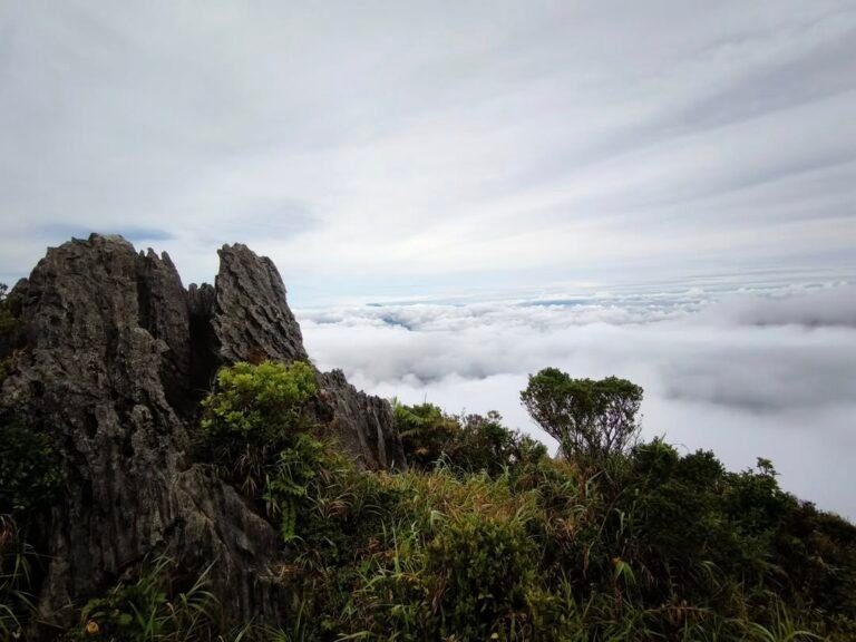
At 1,467 MASL, Mt. Irid holds the distinction of being the highest mountain in Tanay, Rizal. Nestled deep within the Sierra Madre range, this imposing peak is known not only for its rugged wilderness but also for the rare chance to witness a dramatic sea of clouds in Tanay Rizal from one of its limestone outcrops. Unlike the more accessible peaks such as Kulis or Mapalad, Mt. Irid is a true test of endurance, often reserved for seasoned hikers seeking a raw and challenging adventure.
Trail and Hiking Experience
The trail to Mt. Irid begins at Brgy. Sta. Ines, a remote village accessible by rough roads or habal-habal rides. The trek itself is long, averaging 7–8 hours of hiking one way, with around 11 river crossings along the Sta. Ines River. Expect to traverse bamboo forests, mossy trails, and steep limestone ascents that demand strong legs and plenty of stamina. The climb is rated moderate to difficult (4–5/9), with technical sections requiring careful footing, especially after heavy rains when the trail becomes muddy and the river currents stronger.
Fees and Local Requirements
Registration is done at the Sta. Ines Barangay Hall, where hikers typically pay an environmental fee (₱50–₱100). A local guide is mandatory for safety, with guide fees starting at around ₱700 per group. In some cases, hikers are also asked to contribute to a tree-planting or seedling program, part of Tanay’s eco-tourism efforts to preserve its forest ecosystem. Multi-day itineraries may also include fees for overnight camping sites at Sadlak or nearby base camps.
Summit Experience and Best Time to Visit
The summit of Mt. Irid is crowned with limestone cliffs and wide viewpoints, where hikers are rewarded with sweeping panoramas of the Sierra Madre, Sierra Madre ridges, and even neighboring peaks in Rizal and Quezon. On certain mornings—particularly after rainy nights followed by clear skies—the valleys below transform into an ocean of clouds, offering one of the most awe-inspiring Tanay sea of clouds spectacles. Because of its remoteness, these views are often enjoyed in solitude, far from the crowds that frequent the more commercial Tanay peaks.
Practical Tips for Hikers
Go prepared: This is a full-day or overnight climb. Bring at least 3 liters of water, trail food, and proper camping gear if staying overnight.
Wear protective clothing: Leech-infested areas are common; apply repellents and wear leggings.
Check the weather: River crossings can be dangerous during heavy rains—safety always comes first.
Hire experienced guides: They know the safest river crossing points and alternative routes.
For those willing to take on the challenge, Mt. Irid is more than just a mountain—it’s an immersion into the wild beauty of the Sierra Madre. With its raw trails, ecological significance, and the possibility of catching a breathtaking sea of clouds in Tanay Rizal, it stands as a true adventure for serious mountaineers.
7) Mt. Alapaap
If you’re looking for a hike that blends adrenaline, unique landscapes, and the promise of a sea of clouds in Tanay Rizal, then Mt. Alapaap should be on your list. Located in Brgy. San Andres, this mountain may not be as tall as Daraitan or Irid, but it offers a distinct trail experience with rock formations, ridge walks, and technical sections that set it apart from Tanay’s other peaks.
Trail and Hiking Experience
The Mt. Alapaap trail spans roughly 6 kilometers in a circuit and is rated 2–3/9 in difficulty. The hike typically begins in darkness, with groups starting as early as 2:00 to 3:00 a.m. to catch the sunrise at the summit. Along the way, you’ll pass through forest paths, rolling ridges, and several natural landmarks such as Hugot Camp and the iconic Mag-asawang Bato (Twin Rocks). One of the trail’s unique features is a short but steep rappel section, where ropes and bamboo ladders assist hikers down slippery descents. While safe with a guide, this part adds an exciting challenge that adventurous hikers will love.
Fees and Local Requirements
Like most Tanay hikes, climbers must register at the barangay hall in San Andres. Package tours usually cost around ₱800–₱850 per person, which often include transportation from Manila, registration fees, guide services, and a bag tag. If you’re arranging it DIY-style, expect a ₱50 environmental fee plus a guide fee of around ₱500 per group of five. Guides are strongly recommended, especially given the technical sections.
Best Time for Sea of Clouds
The reward for all that effort is the sunrise sea of clouds in Tanay, often viewed from rocky outcrops along the summit ridge. After rainy nights, thick mist blankets the valleys while the peaks stand tall, creating one of the most surreal sunrise backdrops you’ll find in Rizal. On clearer mornings, you also get sweeping views of nearby mountains such as Batolusong and Daraitan.
Practical Tips
Bring gloves and good trekking shoes—the trail has rope segments and muddy slopes.
Start very early to secure the best sunrise viewing spots.
If you’re new to technical trails, join a group tour for safety and convenience.
With its mix of thrill, scenery, and the chance to witness the Tanay sea of clouds, Mt. Alapaap is perfect for hikers seeking more than just a leisurely climb.
6) Mt. Binutasan
Right beside Mt. Sapari is another gem in the Maysawa Circuit—Mt. Binutasan, standing at 577 MASL. Although slightly lower than its twin peak, Binutasan offers equally captivating views and is often praised for its wide, grassy ridges that provide clear vantage points of the sea of clouds in Tanay Rizal. Many hikers choose to conquer both Sapari and Binutasan in one trip, making the circuit a rewarding full-day adventure.
Trail and Hiking Experience
The trail to Mt. Binutasan shares the same jump-off at Brgy. Cuyambay. After a registration stop and a short tricycle ride, the trek begins with forested paths before transitioning into open grasslands and rolling hills. The ascent is considered minor (3/9 difficulty), usually taking 1.5 to 2 hours to reach the summit. Unlike Sapari’s narrower ridges, Binutasan’s summit is broader, allowing groups to spread out and enjoy the panoramic views without feeling crowded.
Fees and Local Requirements
Fees are consistent with the Maysawa Circuit. Visitors pay an environmental fee of ₱100 at the barangay hall, plus a ₱500 guide fee per group of up to five hikers. Local guides are familiar with the best sunrise vantage points and can also assist in navigating the loop trail that connects both peaks.
Best Time for Sea of Clouds
Binutasan is at its most magical during the early morning hours, especially from November to March. After a damp night, the valleys below often fill with a thick blanket of mist, with only the neighboring Sierra Madre ridges poking through. The sunrise glow adds a golden tint to the clouds, creating one of the most photogenic Tanay sea of clouds scenes.
Practical Tips
Pair Binutasan with Sapari for the complete Maysawa Circuit (5–6 hours total).
Bring trekking poles—the grassy slopes can be slippery when wet.
If you prefer a quieter climb, Binutasan tends to attract fewer hikers than Sapari, making it ideal for those who want more space at the summit.
Though often overshadowed by its neighbor, Mt. Binutasan has a charm of its own. With its wide summit, beginner-friendly trail, and stunning morning views, it’s a must for anyone chasing the sea of clouds in Tanay Rizal.
5) Mt. Sapari
For hikers who enjoy ridge walks and sweeping horizons, Mt. Sapari is one of the most rewarding climbs in Tanay. Standing at 592 MASL, this peak is part of the well-loved Maysawa Circuit, usually paired with Mt. Binutasan in a twin hike. While less famous than Daraitan or Batolusong, Sapari has built a reputation among hikers who crave quieter trails and breathtaking sea of clouds in Tanay Rizal.
Trail and Hiking Experience
The trek begins in Brgy. Cuyambay, where visitors must register and secure a local guide. The trail winds through bamboo groves before opening up to grassy ridges that provide uninterrupted views of the Sierra Madre. The hike is considered a minor climb (3/9 difficulty), taking about 2–3 hours to reach the summit. The ridge section is the highlight—here, hikers can walk along narrow paths with mountain slopes on both sides, creating an exhilarating yet beginner-friendly experience.
Fees and Local Requirements
The environmental fee is about ₱100 per person, and a guide costs around ₱500 for every group of four to five hikers. Registration is done at the Cuyambay barangay hall, where tricycles are also available to take groups closer to the jump-off point. The guide requirement ensures both safety and livelihood support for the local community.
Best Time to Catch the Sea of Clouds
Mt. Sapari is best visited at dawn during the dry season (November to March). After rainy nights, the valleys below are often filled with a soft, rolling sea of clouds, while the sun rises to paint the horizon in gold and pink hues. It’s a picture-perfect scene that makes Sapari a favorite among photographers who want a more intimate alternative to the busier Treasure Mountain sea of clouds experience.
Practical Tips
Combine Sapari with Binutasan for a fuller ridge-hiking experience.
Bring a light jacket—ridge winds can be chilly in the early morning.
Arrive at the barangay hall around 2:00–3:00 a.m. to reach the summit by sunrise.
With its accessible trail, affordable fees, and panoramic ridges, Mt. Sapari deserves a spot on every traveler’s list of Tanay sea of clouds adventures.
4) Mt. Mapalad
For hikers looking for both novelty and breathtaking views, Mt. Mapalad has quickly become one of the rising stars among mountains in Tanay. Standing at around 750 MASL, this trail is best known for its iconic “Palm of the Hand” viewing deck, a wooden platform shaped like an open palm that offers hikers a unique perch to witness the rolling hills and the magical sea of clouds in Tanay Rizal.
Trail and Hiking Experience
The trek to Mt. Mapalad takes about 2 to 3 hours one way, with a trail that weaves through bamboo groves, forested slopes, and open ridges. While the hike is considered a minor climb with a difficulty rating of 3/9, certain sections involve steep, muddy paths that can be slippery after rains. Handrails made from bamboo are placed along tricky areas, making the trail manageable even for beginners. The gradual ascent and scenic stops make this mountain a good choice for weekend warriors who want to experience nature without being overwhelmed by a technical climb.
Fees and Local Requirements
Like other mountains in Tanay, hikers must register at Brgy. San Andres. Fees are budget-friendly, averaging around ₱100–₱200 per person, with an additional guide fee of about ₱500 per group. Guides are highly recommended, especially for first-timers, as they not only ensure safety but also share insights about the trail and community.
Best Time for Sea of Clouds
The viewing deck at the summit is the prime spot for sunrise. Arriving just before dawn often rewards visitors with sweeping panoramas of mountain ridges floating above a blanket of clouds. Many travelers describe the scene as “standing on the palm of nature’s hand,” making it one of the most photogenic Tanay sea of clouds experiences.
Practical Tips
Start your hike by 3:00 a.m. to reach the deck before sunrise.
Bring a headlamp, extra water, and snacks, as there are no stores along the trail.
Wear sturdy shoes—muddy sections can be slippery.
Weekdays are the best time to avoid crowds and get a clear shot at the iconic deck.
Mt. Mapalad’s accessibility, unique viewing platform, and stunning morning vistas make it one of the most memorable sea of clouds tourist spots in Tanay Rizal.
Quirino Bridge
Spanning the Abra River between the towns of Bantay and Santa, the Quirino Bridge (also known as Banaoang Bridge) is one of the most photographed tourist attractions in Ilocos Sur. Its graceful steel arches contrast beautifully against the river and surrounding mountains. Named after President Elpidio Quirino, this bridge symbolizes strength and progress.
A designated view deck lets visitors safely stop to capture photos, while pedestrians can stroll along the old preserved portion of the bridge. The site is particularly stunning at sunset, when golden hues reflect off the river.
Insider Tip: It’s a quick detour from Vigan (about 15 minutes by tricycle or car), making it an easy side trip. Visit late afternoon for the best lighting and cooler breeze.
3) Mt. Kulis
If you’re looking for a beginner-friendly hike with rewarding views, Mt. Kulis in Sitio Maysawa, Tanay is one of the easiest gateways to the sea of clouds in Tanay Rizal. Standing at around 620 MASL, this mountain is part of the Fresno Agro-Forestry Eco Park, a community-run campsite that has quickly become popular among weekend adventurers from Metro Manila.
Trail and Unique Features
Unlike more strenuous climbs such as Daraitan or Batolusong, the hike to Mt. Kulis is relatively short—about 20 to 30 minutes from the campsite. The trail is straightforward but can get muddy after rains. What makes Mt. Kulis stand out are its unique rock formations and man-made attractions, including the famous “Noah’s Ark” viewing deck and the rustic “Bahay ni Cardo” made popular by the TV series Ang Probinsyano. At dawn, these spots transform into dramatic vantage points, with the valleys below often blanketed by a soft layer of clouds.
Fees and Local Requirements
Entrance fees are affordable: around ₱150 for day use and ₱200 for overnight camping. If you plan to pitch a tent, there’s a separate tent space fee (~₱300), and rentals are also available for those without gear. Local guides are present at the campsite, and while the trail is manageable even for beginners, they provide valuable assistance and ensure visitor safety.
Best Time for Sea of Clouds
Like most Tanay peaks, the best time to visit Mt. Kulis is during the cool, dry months (November to March). Camping overnight is highly recommended so you can wake up just before sunrise and walk to the view deck for the full Tanay sea of clouds experience. After heavy rains, the chances of seeing this spectacle increase, making the mountain a rewarding choice for both casual travelers and serious photographers.
Practical Tips
Bring layers: Mornings are chilly, especially if you camp.
Headlamp and power bank: Essential if you’re camping overnight.
Go on weekdays: Mt. Kulis is a favorite among joiner tours, so weekends can get crowded.
With its accessibility, affordable fees, and photogenic landscapes, Mt. Kulis is a must-visit for anyone chasing the sea of clouds in Tanay Rizal without committing to a grueling trek.
2) Mt. Batolusong
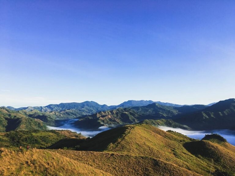
Among the many hiking destinations in Rizal, Mt. Batolusong is one of the most celebrated for sunrise views and the enchanting sea of clouds in Tanay. Rising between 663 MASL (Mapatag Plateau) and 883 MASL (Rangyas Peak), this mountain sits at the heart of Brgy. San Andres, Tanay. Its accessibility and stunning sceneries have made it a favorite weekend escape for both casual hikers and serious mountaineers.
Trail Features and Scenery
The journey to Mt. Batolusong begins with a gentle ascent through grasslands dotted with cogon, where the first rays of sunlight create a golden carpet across the hills. As the trail continues, pine trees and open ridges replace the grasslands, providing sweeping views of the Sierra Madre range. The two major stops—Mapatag Plateau and Rangyas Peak—are the highlights of this hike. Mapatag is often recommended for beginners, offering panoramic vistas without the steeper climb, while Rangyas Peak rewards those who push further with a 360-degree perspective of Rizal’s rugged beauty.
Fees and Local Requirements
Hikers must register at the San Andres barangay hall before beginning the trek. The entrance fee is typically around ₱50 per person, and hiring a local guide is strongly recommended. Guide fees vary depending on group size but usually cost ₱500–600 per group. These fees directly support the local community, who not only ensure the safety of hikers but also maintain the trails.
Best Time to Witness the Sea of Clouds
The sunrise sea of clouds in Tanay is the prime reason many choose to hike Mt. Batolusong. To catch this spectacle, hikers usually begin their trek before dawn, aiming to reach Mapatag Plateau or Rangyas Peak just as the sun rises. After rainy nights followed by clear mornings, the valleys below are often submerged in thick, rolling clouds, creating the illusion of floating islands. This breathtaking view has cemented Mt. Batolusong as one of the must-visit mountains in Rizal.
Practical Tips for Visitors
Start your hike early—around 3:00 to 4:00 a.m.—to secure the best sunrise vantage point.
Bring layered clothing; mornings at the plateau can be chilly.
Prepare for sudden weather changes—rain gear is essential during the wet season.
Pack enough snacks and water; there are limited stores along the trail.
Whether you’re a first-time hiker looking for an accessible adventure or a seasoned mountaineer chasing the next sunrise, Mt. Batolusong offers one of the most unforgettable Tanay sea of clouds experiences.
1) Mt. Daraitan
At 739 meters above sea level (MASL), Mt. Daraitan has earned its reputation as one of the crown jewels of Tanay’s mountain landscape. Nestled within the Sierra Madre range, this mountain is not only famous for its rugged terrain and panoramic views, but also for offering one of the most dramatic sightings of the sea of clouds in Tanay Rizal. For many hikers, reaching Daraitan’s summit is both a physical challenge and a spiritual reward, as it combines raw adventure with unforgettable natural beauty.
Trail Details and Difficulty
The trek to Daraitan is considered a moderate climb that usually takes 3–4 hours one way, depending on pace. The trail tests hikers with river crossings, steep ascents, and limestone outcrops that require careful footing. Along the way, the path winds through dense forest canopies, exposing you occasionally to open ridges that preview the views awaiting at the summit. Because of these varied conditions, sturdy shoes with good traction and gloves for gripping sharp rocks are highly recommended.
Fees and Local Requirements
Visitors are required to register at the Daraitan Barangay Hall before starting the climb. Current fees include a ₱50 environmental fee per person plus a ₱700 guide fee for every group of five hikers. The presence of a local guide is mandatory, not only for safety but also to support the livelihood of the community. Many guides share stories about the mountain, adding cultural depth to the experience.
Summit Experience and Best Time to Visit
The true highlight of Mt. Daraitan is at sunrise. After a rainy evening followed by clear skies, the valleys below often transform into an ocean of clouds, with only the ridges and distant peaks visible. This breathtaking Tanay sea of clouds spectacle has made Daraitan a bucket-list climb for both seasoned mountaineers and weekend adventurers. Beyond the summit, the nearby Tinipak River with its marble-like limestone formations is an equally captivating side trip, perfect for cooling down after the trek.
Practical Tips for First-Time Climbers
Timing is key: Arrive at the trailhead by midnight or 1:00 a.m. to catch the sea of clouds at dawn.
Gear up: Gloves, trekking poles, and headlamps are highly useful.
Hydrate and fuel up: The climb is long and tiring, so bring at least 2 liters of water and high-energy snacks.
Respect the environment: Follow Leave No Trace principles and support local guides.
In short, Mt. Daraitan offers a balance of challenge and reward, making it one of the must-visit peaks if you’re chasing the sea of clouds in Tanay Rizal.
Practical Travel Tips
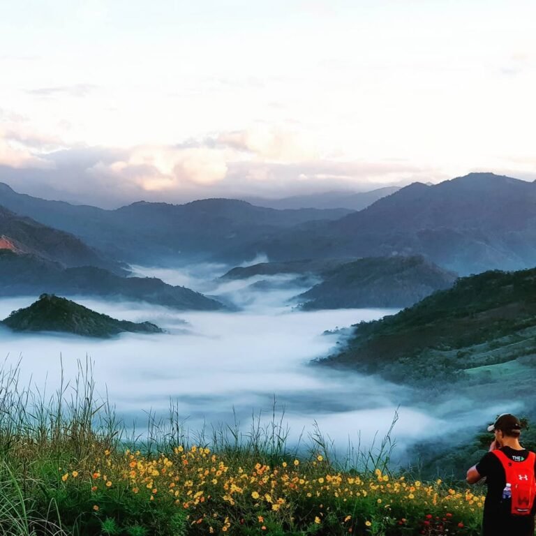
Planning a hike to witness the sea of clouds in Tanay isn’t just about showing up at dawn—it’s about preparation, timing, and knowing what to expect. Over the years, I’ve learned from personal climbs and local tourism update that the right strategy can make the difference between catching a breathtaking cloud inversion or missing it entirely.
Best Time to Visit
The dry season from November to March is the golden window for chasing the sea of clouds in Tanay Rizal. Trails are more manageable and the cool mornings favor cloud formation. If you want the best chance of catching the phenomenon, start your trek between 3:00 and 4:00 AM so you can reach the summit just as the sun rises. By 7:00 AM, most clouds begin to thin out.
What to Bring
Early treks require a reliable headlamp. A light jacket keeps you warm against ridge-top winds, while rain gear prepares you for sudden showers along the Sierra Madre. Always pack at least two liters of water, trail snacks, and a first aid kit. In mountains like Mt. Daraitan and Mt. Batolusong, where river crossings and rocky scrambles are common, sturdy footwear and gloves are indispensable.
Who Can Join
The beauty of Tanay is that its mountains cater to every traveler. Families and beginners often head to Treasure Mountain or Mt. Kulis, where the sea of clouds tourist spot in Tanay Rizal is easily accessible. Meanwhile, experienced hikers can challenge themselves with major climbs like Mt. Irid. Whether you’re hiking solo, with friends, or joining a tour group, Tanay offers safe, guided options for all.
Budget Estimate
Depending on the mountain and your transport, expect to spend around ₱500–₱1,500 per person. Day hikes on easier peaks are more affordable, while multi-day climbs with permits, transport, and guides—like those in remote barangays—are costlier. Bring cash, as digital payments are rarely available in the uplands.
Safety Tips
Always register at barangay halls before setting out. Guides are mandatory and ensure safety, especially in unpredictable weather. While rain before your hike increases your chance of witnessing the sea of clouds Tanay Rizal, it also makes trails slippery, so be cautious. Lastly, follow Leave No Trace principles to preserve Tanay’s environment and keep its mountains a world-class destination for future adventurers.
Conclusion – Why Tanay is the Sea of Clouds Capital Near Manila
After exploring ten incredible mountains—each with its own personality—it’s clear why hikers call Tanay the sea-of-clouds capital near Manila. From the dramatic limestone ridges of Mt. Daraitan to the iconic viewing deck of Mt. Mapalad, from the grassy summits of the Maysawa Circuit to the lofty heights of Mt. Irid, every trail showcases the elusive beauty of the sea of clouds in Tanay.
For travelers searching for a must-see tourist spot in Tanay Rizal, these mountains deliver in ways few places near Manila can. Just two to three hours away from the city, Tanay offers a blend of accessibility and wilderness that makes it a magnet for weekend adventurers, photographers, families, and even first-time hikers. Whether it’s your first sunrise hike or your tenth climb, the experience never loses its magic.
But chasing the sea of clouds Tanay Rizal is also a responsibility. The views depend on weather, timing, and nature’s delicate balance. Practicing sustainable travel, hiring accredited guides, and respecting local communities ensure that future generations will continue to enjoy these wonders.
On a personal note, I’ve lost count of how many times I’ve stood on a summit in Tanay at dawn, only to be greeted by a rolling ocean of clouds. Each time feels new, humbling, and deeply rewarding. The sea of clouds in Tanay isn’t just a view—it’s a reminder of how close breathtaking nature is to Manila, and how important it is for us to protect it.
Frequently Asked Questions on the Sea of Clouds in Tanay
1. What is the best time to see the sea of clouds in Tanay?
The best season is November to March, during the dry months. Start hikes at 3:00–4:00 AM to reach the summit before sunrise, when clouds are thickes.
2. Which mountains in Tanay are beginner-friendly?
Treasure Mountain and Mt. Kulis are popular for families and first-timers. They require little to no hike and still offer stunning sea of clouds in Tanay Rizal views.
3. What are the most challenging hikes for the sea of clouds?
Mt. Irid and the Maysawa Circuit (Mt. Sapari & Mt. Binutasan) are longer and more demanding. These require guides, permits, and good fitness.
4. How much does a trip usually cost?
Budget around ₱500–₱1,500 per person depending on the mountain, transport, and guide fees. Bring cash since upland barangays seldom accept digital payments.
5. Do I need a guide?
Yes. Almost all mountains require accredited local guides for safety and environmental compliance. Fees range from ₱500–₱900 per group/day.
6. How do I get to Tanay from Manila?
From Cubao or Shaw Boulevard, ride a jeep or van to Tanay Public Market. From there, take tricycles or jeepneys to barangay jump-off points.
7. Are permits required?
Some trails like Mt. Irid and Mt. Tinucan Circuit need prior permits from barangay offices or the Tanay MENRO. Others only require registration and environmental fees.
8. What should I bring?
Essentials include a headlamp, jacket, rain gear, water, snacks, and trekking shoes. For rocky climbs like Mt. Daraitan, gloves are useful.
9. Is camping allowed?
Yes. Peaks such as Mt. Daraitan, Mt. Kulis, and Mt. Mapalad have campsites. Overnight fees range from ₱50–₱300 per person.
10. Why is Tanay known as the sea-of-clouds capital near Manila?
With ten accessible mountains offering diverse trails and reliable dawn cloud formations, Tanay is the most consistent and scenic tourist spot in Tanay Rizal for this natural wonder.