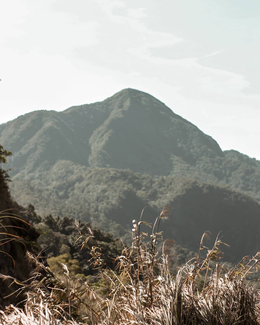
Mount Natib is a dormant stratovolcano located in Bataan, Philippines, known for its towering presence and rich geological history. This impressive volcano forms part of the Bataan Peninsula and stands as a testament to the dynamic natural forces that have shaped the region. The term “dormant” means that while Mount Natib is not currently erupting, it has shown volcanic activity in the past and has the potential to become active again.
The last eruption of Mount Natib is estimated to have occurred between the upper Pleistocene to Holocene periods, which dates back to around 11,000 to 18,000 years ago according to studies by Dr. Kevin Rodolfo. This timeline places its last known activity in a prehistoric era, long before recorded history began. Despite the lack of recent eruptions, the Philippine Institute of Volcanology and Seismology (PHIVOLCS) classifies Mount Natib as a potentially active volcano due to its geological features and the presence of thermal areas, including hot springs within its caldera.
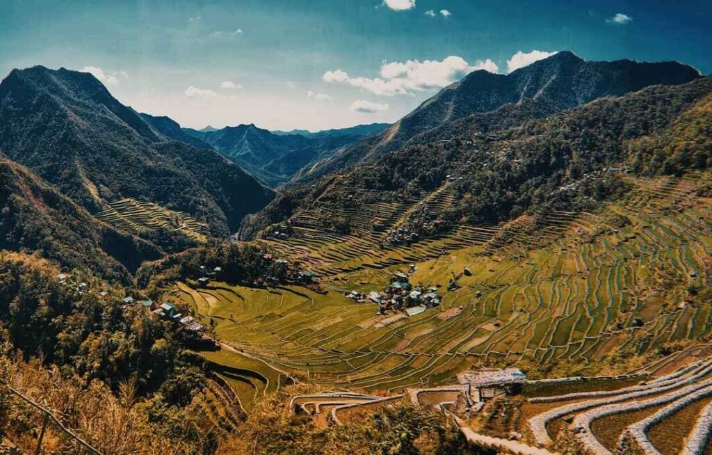
Mount Natib is a significant geological feature in Bataan, with a large acorn-shaped caldera that measures approximately 6 by 7 kilometers. This caldera, along with the smaller Pasukulan Caldera, creates a unique landscape that attracts hikers and nature enthusiasts. The volcanic rocks in the area are primarily andesite and dacite, which provide insights into the volcanic processes that formed the mountain.
Understanding the history and characteristics of Mount Natib not only highlights the natural beauty and adventure it offers but also underscores the importance of respecting and preserving this remarkable natural landmark. source (Wikipedia) (Global Volcanism Program).
Read our blog about Tourist Spot in Bataan, Tarak Ridge and Laki beach for more tourist destination in Bataan.
Table of Contents
Mount Natib’s Geological Features
Mount Natib is a fascinating geological marvel situated in Bataan, Philippines. As a stratovolcano, it is characterized by a layered structure formed by multiple eruptions over time. This type of volcano typically has steep sides and is made up of alternating layers of lava flows, volcanic ash, and other volcanic debris.
One of the standout features of Mount Natib is its caldera complex. A caldera is a large volcanic crater, often formed by the collapse of land following an eruption. Mount Natib boasts two notable calderas. The larger of the two, the Natib Caldera, measures approximately 6 by 7 kilometers. This expansive caldera creates a dramatic landscape and is a key feature for visitors exploring the area. Adjacent to this is the smaller Pasukulan Caldera, adding to the unique geological structure of the mountain.
The rock types found in Mount Natib further illustrate its volcanic nature. The primary rocks are andesite, basalt, and dacite. Andesite is a volcanic rock with a composition between that of basalt and dacite. Basalt is a common volcanic rock that is typically dark in color and rich in iron and magnesium. Dacite, on the other hand, is lighter in color and contains higher amounts of silica. These rocks are remnants of past volcanic activities and provide a glimpse into the mountain’s eruptive history.
Mount Natib’s geological features not only make it a site of scientific interest but also a captivating destination for hikers and nature enthusiasts. The combination of its stratovolcano structure, impressive calderas, and diverse rock types create a landscape that is both educational and visually stunning.
Mount Natib: Active or Inactive?
Mount Natib, located in Bataan, Philippines, is classified as a potentially active volcano by the Philippine Institute of Volcanology and Seismology (PHIVOLCS). This classification means that while Mount Natib has not erupted in recent history, it still shows signs of potential volcanic activity and could erupt again in the future. This is an important distinction because it helps scientists and residents remain aware and prepared for any possible changes in the volcano’s behavior .
One of the key indicators of Mount Natib’s potential activity is the presence of several thermal areas within its caldera. These thermal areas include hot springs, which are natural springs that produce hot water. The hot springs within Mount Natib’s caldera are Asin, Mamot, Tigulangin, Uyong, and Paipit springs. The temperatures of these hot springs range from 30°C to 56°C, indicating ongoing geothermal activity beneath the surface.
The presence of these hot springs and thermal areas suggests that there is still heat being generated within Mount Natib, which is a typical characteristic of potentially active volcanoes. The heat from the Earth’s interior warms the groundwater, creating these hot springs. This geothermal activity is monitored by scientists to understand better the volcano’s current state and to predict any future activity.
In summary, Mount Natib is classified as a potentially active volcano due to its geological features and the presence of thermal areas. While it has not erupted in recent history, the ongoing geothermal activity within its caldera signifies that it is not completely dormant. This classification emphasizes the importance of continuous monitoring and preparedness for any potential volcanic activity.
Historical Significance of Mount Natib
Mount Natib, a dormant stratovolcano in Bataan, Philippines, holds significant historical and cultural importance in the region. Its towering presence has not only shaped the physical landscape but also played a role in the area’s historical events and environmental conservation efforts.
The Bataan Peninsula, where Mount Natib is located, has been a critical site throughout Philippine history. During World War II, Bataan was the stage for the infamous Bataan Death March, where thousands of Filipino and American soldiers were forced to march by Japanese forces. While Mount Natib itself was not the focal point of these events, its surrounding landscapes witnessed these historical moments, embedding the volcano in the region’s wartime history .
In 1945, Bataan National Park was established, encompassing Mount Natib and its surrounding areas. This protected area was created to preserve the unique flora and fauna of the region and the geological features of Mount Natib. The park spans approximately 23,688 hectares and is a sanctuary for various wildlife species, making it a vital conservation area.
Mount Natib’s inclusion in Bataan National Park highlights its ecological importance. The park serves as a habitat for endangered species and is a key area for biodiversity. The establishment of the park not only protects the natural environment but also promotes eco-tourism, providing visitors with opportunities to explore the beauty of Mount Natib and its lush surroundings.
Overall, Mount Natib’s historical significance is intertwined with the broader history of the Bataan region. Its designation as part of Bataan National Park underscores the importance of preserving this natural landmark for future generations to appreciate and enjoy.
Mount Natib and Pasukulan Falls
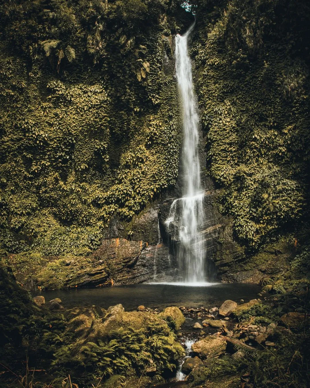
Mount Natib, a dormant stratovolcano in Bataan, Philippines, is not just a geological wonder but also a gateway to some of the region’s most stunning natural attractions. One such attraction is Pasukulan Falls, a hidden gem located near Mount Natib. This waterfall is a must-visit for nature lovers and adventure seekers alike, offering a refreshing escape into nature’s beauty.
Natural Beauty and Attractions of Pasukulan Falls
Pasukulan Falls is renowned for its pristine waters and serene environment. Nestled within the lush forests of Bataan National Park, the falls provide a tranquil setting that is perfect for relaxation and rejuvenation. The waterfall cascades down into a clear pool, making it an ideal spot for swimming and cooling off after a hike. The surrounding area is rich in biodiversity, with various plant and animal species that add to the enchanting atmosphere of the falls.
The journey to Pasukulan Falls offers hikers a chance to immerse themselves in the natural beauty of Mount Natib’s landscape. The trail winds through dense forests, across streams, and over rocky terrain, providing stunning views and opportunities to spot wildlife along the way. The sound of the waterfall gradually grows louder as you approach, building anticipation for the breathtaking sight that awaits.
Tips for Visiting Pasukulan Falls
Prepare for the Hike: The hike to Pasukulan Falls can be challenging, so it’s important to come prepared. Wear sturdy hiking shoes, bring plenty of water, and pack light snacks to keep your energy levels up.
Start Early: Begin your hike early in the morning to take advantage of cooler temperatures and to ensure you have ample time to enjoy the falls. Early starts also mean fewer people on the trail, allowing for a more peaceful experience.
Hire a Local Guide: Local guides are available and can enhance your hiking experience. They are knowledgeable about the trail, the flora and fauna, and can ensure you don’t miss any of the key sights along the way.
Respect Nature: As Pasukulan Falls is part of a protected area, it’s crucial to respect the environment. Avoid leaving any trash behind, stick to designated trails, and do not disturb the wildlife.
Safety First: Always prioritize safety. Inform someone about your hiking plans and expected return time. Be mindful of slippery rocks around the waterfall and avoid venturing too close to the edge.
Enjoy the Experience: Take your time to appreciate the natural beauty of Pasukulan Falls. Bring a camera to capture the scenic views, but also take moments to simply soak in the peaceful surroundings without distractions.
Visiting Pasukulan Falls as part of a hike to Mount Natib is an unforgettable experience, blending the thrill of adventure with the serenity of nature. This journey not only offers spectacular views and a refreshing dip in the waterfall but also a deeper appreciation for the natural wonders that Bataan has to offer.
How to go to Mount Natib
Mount Natib is situated in the northern part of the Bataan Peninsula, in the province of Bataan, Philippines. It is located near the towns of Orani, Samal, and Hermosa, making it relatively accessible for visitors. The mountain is part of the Bataan National Park, which is known for its rich biodiversity and natural beauty.
Getting to Mount Natib from Major Cities
From Manila:
By Car:
- Route: The fastest way to reach Mount Natib from Manila is by taking the North Luzon Expressway (NLEX). Drive north on NLEX and take the exit to Subic-Clark-Tarlac Expressway (SCTEX). Continue on SCTEX and take the Dinalupihan exit. From there, follow the signs to Orani, Bataan. The drive from Manila to Orani usually takes about 2-3 hours, depending on traffic.
- Directions: Once in Orani, head towards Bataan National Park. Local signs and directions will guide you to the starting point of the hike to Mount Natib.
By Public Transportation:
- Bus: Several bus companies operate routes from Manila to Bataan. You can take a bus from Cubao or Pasay to Balanga City, Bataan. The journey takes approximately 2-3 hours. From Balanga, you can take a jeepney or a tricycle to Orani.
- Jeepney/Tricycle: From Orani, you can hire a tricycle to take you to the trailhead of Mount Natib.
From Clark:
By Car:
- Route: Drive south on SCTEX and take the Dinalupihan exit. Follow the signs to Orani, Bataan. The drive from Clark to Orani typically takes about 1-2 hours.
- Directions: Once in Orani, follow the local signs to Bataan National Park and the trailhead for Mount Natib.
By Public Transportation:
- Bus: Take a bus from Clark to Balanga City, Bataan. From Balanga, transfer to a jeepney or tricycle to reach Orani and subsequently, the trailhead.
From Subic:
By Car:
- Route: Drive south from Subic on SCTEX and take the Dinalupihan exit. Continue towards Orani, Bataan. The drive from Subic to Orani takes about 1-1.5 hours.
- Directions: Follow local directions to Bataan National Park and the trailhead for Mount Natib.
By Public Transportation:
- Bus: Take a bus from Subic to Balanga City, Bataan. From Balanga, take a jeepney or tricycle to Orani and then to the trailhead.
Local Guide and Preparation:
- Guides: Hiring a local guide is recommended for first-time hikers. They can provide valuable information about the trail and ensure your safety.
- Preparation: Make sure to bring plenty of water, snacks, and proper hiking gear. The hike can be challenging, so being well-prepared is crucial.
Mount Natib’s location in the Bataan Peninsula, combined with its accessibility from major cities like Manila, Clark, and Subic, makes it an attractive destination for hikers and nature enthusiasts. The journey to the mountain is an adventure in itself, offering scenic views and a glimpse into the rich natural heritage of the region.
2-Day Itinerary for Hiking Mount Natib
Planning a two-day hike to Mount Natib in Bataan, Philippines, offers an immersive experience combining adventure, natural beauty, and a bit of history. Here’s a comprehensive itinerary to help you make the most of your trip to Mount Natib and Pasukulan Falls, ensuring you utilize your focus keyword and sub-keywords.
Day 1: Ascent to Mount Natib
Early Morning: Departure and Arrival
- 1:00 AM: Assemble at McDonald’s Eton Centris near Alorica and BMW.
- 2:00 AM: Departure from Manila to Orani, Bataan. The drive takes about 3 hours.
- 5:00 AM: Arrive at the Sinag Tala Entrance. Have breakfast, register, and secure guides.
Morning: Start the Hike
- 6:00 AM: Begin the trek with a van ride to the view deck.
- 6:30 AM: Arrive at the view deck for a brief rest and photo ops.
- 7:00 AM: Continue hiking to Kubo, a water source checkpoint.
- 8:30 AM: Reach the junction and prepare for the summit assault.
Late Morning to Early Afternoon: Summit and Descent
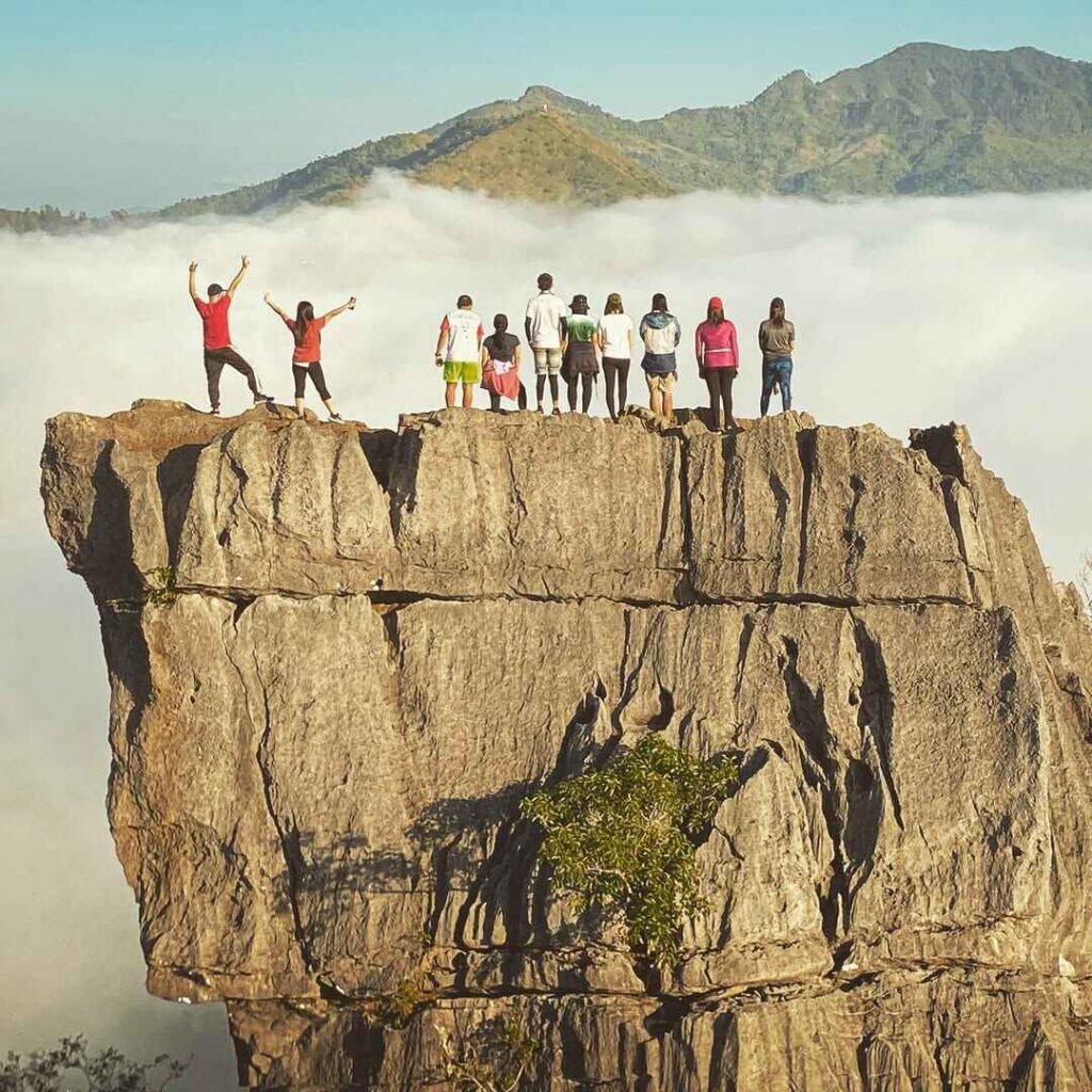
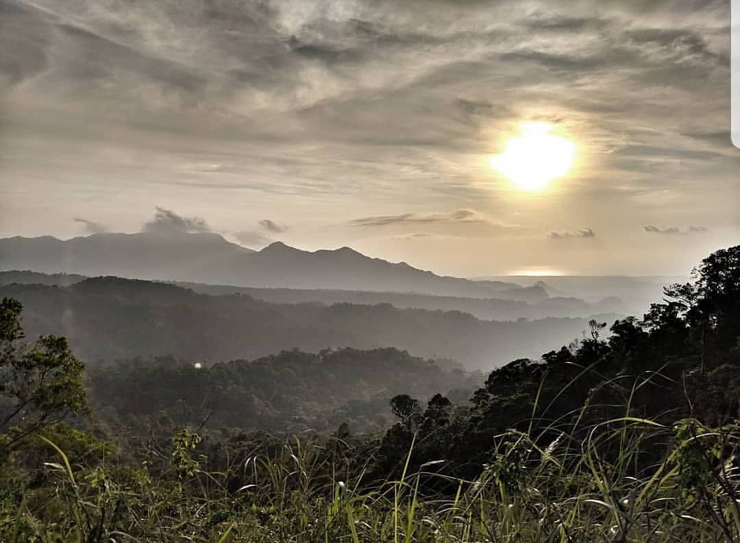
- 10:30 AM: Arrive at the summit of Mount Natib. Enjoy panoramic views, take photos, and have a snack.
- 11:00 AM: Start descending back to the junction.
Afternoon: Journey to Pasukulan Falls
- 12:30 PM: At the junction, begin the trek to Pasukulan Falls. Enjoy lunch along the way.
- 2:00 PM: Arrive at Pasukulan Falls. Take time to relax, swim, and explore the area.
Evening: Camping and Socials
- 3:00 PM: Set up camp near Pasukulan Falls.
- 6:30 PM: Have dinner and enjoy social time with fellow hikers.
Day 2: Enjoy Pasukulan Falls and Return
Morning: Leisure and Exploration
- 7:00 AM: Wake up and enjoy the natural beauty of Pasukulan Falls. Take a morning swim and capture photos.
- 8:00 AM: Break camp and prepare for the hike back.
Late Morning to Early Afternoon: Return Trek
- 9:00 AM: Start the descent back to the junction.
- 12:00 PM: Stop for lunch along the trail.
Afternoon: Final Descent and Departure
- 1:00 PM: Continue descending to the jump-off point.
- 4:00 PM: Arrive back at the jump-off point. Freshen up and prepare for departure.
- 5:00 PM: Depart for Manila.
- 8:00 PM: Arrive in Manila. Celebrate your successful hike with a victory dinner along the way.
This two-day itinerary for Mount Natib and Pasukulan Falls ensures you experience the full beauty and adventure of this incredible region, incorporating the focus keyword and sub-keywords naturally to enhance your blog’s SEO. Enjoy your hike and the breathtaking sights along the way!
Safety Tips and Guidelines for Hiking Mount Natib
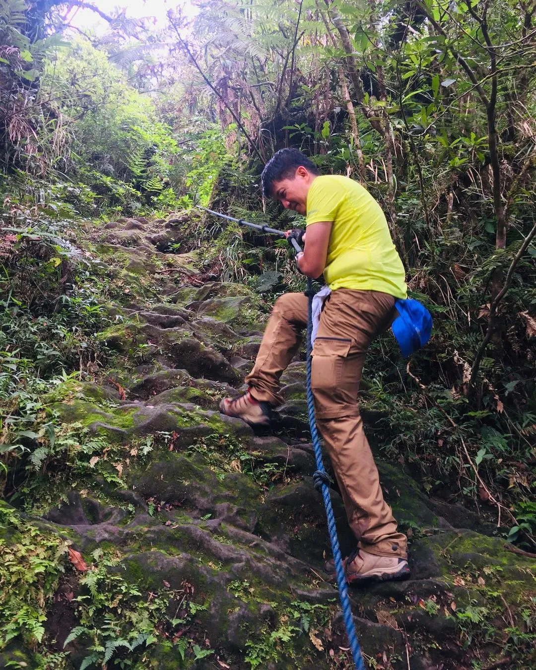
Hiking Mount Natib in Bataan, Philippines, is an exciting adventure, but it’s important to prioritize safety and environmental stewardship. Here are some key safety tips and guidelines to ensure a safe and enjoyable visit, incorporating the focus keyword “Mount Natib” and sub-keywords naturally.
Important Safety Information for Hikers
Proper Gear:
- Footwear: Wear sturdy hiking boots with good traction to handle the rocky and uneven terrain of Mount Natib.
- Clothing: Dress in lightweight, moisture-wicking clothes. Bring layers to adjust to changing weather conditions and a rain jacket or poncho.
- Headlamp: Essential for early morning or late evening hikes, ensuring you can see and be seen in low light conditions.
- First Aid Kit: Carry a basic first aid kit with bandages, antiseptic wipes, pain relievers, and any personal medications.
Hydration and Nutrition:
- Water: Bring at least 3 liters of water per person. Staying hydrated is crucial, especially on a strenuous hike like Mount Natib.
- Snacks: Pack high-energy snacks such as nuts, dried fruits, energy bars, and a packed lunch to keep your energy levels up during the hike.
Trail Awareness:
- Navigation Tools: Carry a map, compass, or GPS device. Although the trail is generally marked, these tools are invaluable if you get off track.
- Local Guide: Consider hiring a local guide who is familiar with the trail and can provide insights and ensure your safety.
- Group Hiking: If possible, hike in a group. There’s safety in numbers, and it can be more enjoyable and motivating.
Weather Preparedness:
- Check the Forecast: Always check the weather forecast before your hike. Avoid hiking in severe weather conditions as it can make the trail dangerous.
- Plan for Changes: Weather can change rapidly in mountainous areas. Be prepared for rain, fog, or sudden temperature drops.
Emergency Plan:
- Inform Others: Let someone know your hiking plans, including your route and expected return time. This is crucial in case of an emergency.
- Emergency Contacts: Have a list of emergency contacts, including local authorities and park rangers.
By following these safety tips and environmental guidelines, you can help preserve the natural beauty of Mount Natib and ensure a safe and enjoyable hike. Remember, being well-prepared and respectful of the environment enhances your hiking experience and protects this remarkable destination for future visitors.
Conclusion
In this blog, we’ve explored the many facets of Mount Natib, a dormant stratovolcano located in Bataan, Philippines. Here’s a recap of the key points covered:
Introduction to Mount Natib: We discussed Mount Natib’s status as a dormant stratovolcano, highlighting its estimated last eruption during the upper Pleistocene to Holocene period.
Geological Features: We detailed the unique geological aspects of Mount Natib, including its large caldera complex and the smaller Pasukulan Caldera. We also covered the primary rock types found in the area, such as andesite, basalt, and dacite.
Activity Status: We clarified Mount Natib’s classification as a potentially active volcano according to PHIVOLCS and provided an overview of the thermal areas and hot springs within its caldera.
Historical Significance: We delved into the historical importance of Mount Natib and its surrounding region, including its inclusion in the Bataan National Park established in 1945.
Mount Natib and Pasukulan Falls: We highlighted the natural beauty and attractions of Pasukulan Falls, offering tips for visiting the falls as part of a hike to Mount Natib.
Location and Accessibility: We provided detailed location information and directions on how to get to Mount Natib from major cities such as Manila, Clark, and Subic.
Hiking Mount Natib: We offered an overview of the hike’s difficulty level and trail conditions, along with recommendations for preparation and essential items to bring.
2-Day Itinerary: We shared a comprehensive two-day itinerary for hiking Mount Natib, ensuring a well-rounded and immersive experience.
Safety Tips and Guidelines: We emphasized important safety information for hikers, including the need to beware of limatik (leeches), and guidelines for respecting the natural environment.
Mount Natib is a remarkable destination that offers both challenging hikes and breathtaking scenery. Its rich history, diverse geological features, and natural beauty make it a must-visit for nature enthusiasts and adventure seekers alike. By following the tips and guidelines provided, you can ensure a safe, respectful, and memorable hiking experience.
We encourage you to explore and appreciate the natural beauty of Mount Natib and its surroundings. Whether you’re an experienced hiker or a casual nature lover, Mount Natib provides an unparalleled opportunity to connect with nature and discover the wonders of Bataan. Happy hiking!
Frequently Asked Questions about Mount Natib
1. Is Mount Natib active or inactive?
Answer: Mount Natib is classified as a potentially active volcano by the Philippine Institute of Volcanology and Seismology (PHIVOLCS). This means that while there have been no recent eruptions, the presence of geothermal activity, such as hot springs, indicates that it could become active again in the future.
2. How difficult is the hike to Mount Natib?
Answer: The hike to Mount Natib is considered moderately difficult to challenging. The trail involves steep ascents, roped segments, and navigating through dense forests. It’s suitable for experienced hikers or those in good physical condition. The entire hike, including the ascent to the summit and the visit to Pasukulan Falls, can take around 5-7 hours each way.
3. What should I bring for the hike to Mount Natib?
Answer: Essential items to bring for the hike to Mount Natib include sturdy hiking boots, plenty of water (at least 3 liters), high-energy snacks, a rain jacket, a first aid kit, and navigation tools (map or GPS). Since the area is known for limatik (leeches), wearing long sleeves and pants and using insect repellent is recommended. Additionally, a headlamp for early or late hikes, extra clothes, and sun protection are also necessary.
4. How do I get to Mount Natib from Manila?
Answer: To reach Mount Natib from Manila, you can take a bus from terminals like Bataan Transit or Genesis Lines near the LRT Doroteo Jose station. The bus ride to Orani, Bataan, takes about 2-3 hours. From Orani, you can hire a tricycle to the jump-off point at Barangay Tala. The total travel time from Manila to the trailhead is approximately 3-4 hours.
5. What can I see and do at Pasukulan Falls?
Answer: Pasukulan Falls, located near Mount Natib, is a stunning natural attraction known for its clear, refreshing waters and serene environment. It’s a perfect spot for swimming, relaxing, and taking in the beauty of the surrounding forest. The hike to the falls involves crossing several rivers and navigating through rugged terrain, making it an adventurous addition to the Mount Natib hike. Be prepared for a challenging but rewarding trek.