
Is Mt. Mariglem Worth Climbing?
Mt. Mariglem is absolutely worth climbing — especially if you want a rewarding first or second mountain that combines open ridge views, cool river crossings, and manageable elevation without requiring technical skill. It suits fit beginners and intermediate hikers who are willing to start before dawn and respect the heat on the exposed upper trail.
Mt. Mariglem Quick Guide
| Item | Detail |
|---|---|
| Mountain | Mt. Mariglem |
| Location | Sitio Maporac, Brgy. New San Juan, Cabangan, Zambales |
| Province | Zambales |
| Elevation | 573 MASL |
| Difficulty | 3–4 out of 9 (beginner-friendly, heat-dependent) |
| Jump-off | Sitio Maporac trailhead via kolong-kolong |
| Best Season | December to February |
| Trek Time | 2–3 hours to summit, roughly 4–5 hours total with river |
| Registration | On-site at Sitio Maporac; pre-book via phone or Facebook on weekdays |
| Campsite | No summit camping; river-area camping may be permitted (confirm locally) |
Before conquering Mt. Mariglem or any off-the-beaten-path destination in the Philippines, don’t forget to get covered with travel insurance. We recommend SafetyWing Nomad Insurance for its flexible, subscription-based plans perfect for weekend warriors and long-term adventurers alike. With emergency medical coverage, trip interruptions, and worldwide support, it’s peace of mind that fits in your backpack.This is an affiliate link. I may earn a small commission if you sign up, at no extra cost to you. I only recommend services I trust

Table of Contents
Where Is Mt. Mariglem Located?
Mt. Mariglem sits inside Sitio Maporac, Barangay New San Juan, in the municipality of Cabangan, Province of Zambales — about four and a half to six hours from Manila by bus. It rises to 573 MASL within the broader Zambales Mountains Key Biodiversity Area, and the approach passes through an Ayta community area, which gives the whole experience a cultural weight that most day-hike destinations in the region don’t have.
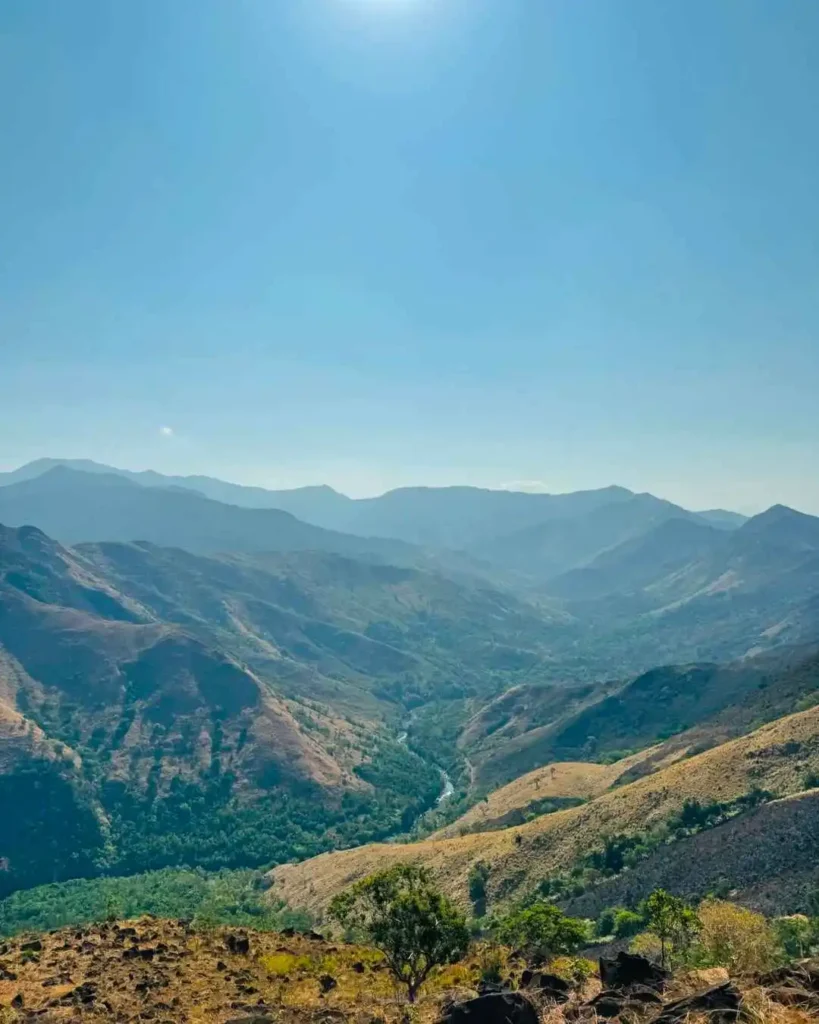
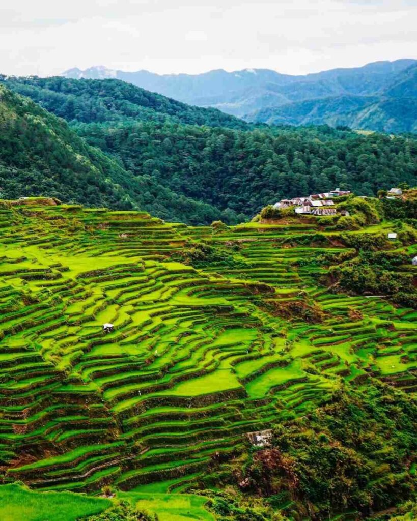
The mountain’s defining physical feature is its ridge-to-river format. You climb open, grassy ridges with increasingly wide sightlines toward the West Philippine Sea, then descend into river valleys — specifically the Maligha and Agbobotilya rivers — for a cooling finish. That sequence is what separates a Mt. Mariglem hike from a straightforward summit-and-back, and it’s the reason hikers who come once tend to come back.
For context, alongside other peaks in the area, the mountains of the Philippines travel guide and the Zambales ultimate travel guide both offer helpful regional framing.
How to Get to the Mt. Mariglem Jump-off Point
Getting to Mt. Mariglem from Manila is a three-leg journey: bus to Cabangan, tricycle to Sitio Maporac, then a kolong-kolong to the trailhead. None of it is complicated, but you need to time each leg correctly.
By bus, board a Victory Liner bus bound for Iba or Sta. Cruz, Zambales from any of the Manila terminals — Caloocan, Cubao, Pasay, or Earnshaw/Sampaloc. Tell the conductor you’re getting off at Cabangan. Budget ₱450–₱600 one-way; the fare to nearby Iba runs ₱495–₱640, so Cabangan lands at the lower end of that band depending on terminal and bus class. Travel time is roughly 4.5 to 6 hours from Manila, so most serious hikers depart by midnight to 1:00 AM to arrive in the pre-dawn window.
From the Cabangan drop-off, hire a tricycle to Sitio Maporac for around ₱300 per trip (or local short-hop rates if other passengers share). Once in Maporac, you register and then ride a kolong-kolong — a locally modified open-air vehicle — to the actual trailhead. The going rate is around ₱550 per kolong-kolong for up to five people, or roughly ₱100 per head if you fill it. The kolong-kolong leg takes about 15 minutes and covers rough road that would be rough on any ordinary vehicle.
Private vehicles can reach Cabangan without issue, but I haven’t confirmed exact parking arrangements at the Maporac staging area — ask when you pre-book, since that detail is worth clarifying directly with the local coordinator.
Permits, Fees, and Guide Requirements at Mt. Mariglem
A guide is mandatory at Mt. Mariglem, and that’s non-negotiable in current local policy. The enforced ratio is 1 guide for every 5 hikers, so a solo hiker still pays for a guide. guide fee at ₱700 per guide for up to 5 hikers, though some 2026 DIY group ₱1,500 per group per day — the safest working range is ₱700–₱1,500 per group, and you’ll want to confirm the exact rate when you pre-book.
The local entrance/registration fee is ₱50 per hiker; some reports budget up to ₱100, so treat ₱50–₱100 as the confirmed range. There is no published online self-booking portal. The standard flow is: pre-book by phone or Facebook on weekdays, arrive at Sitio Maporac, register and pay on-site, sign the logbook or waiver, collect your guide, and then ride the kolong-kolong to the trailhead. Walk-in hikers have historically been accommodated Tuesday through Friday; weekends require advance reservation.
For emergencies or pre-hike coordination, use the local booking line 0949 879 1342, the Cabangan municipal line 0917 508 9672, or the Cabangan emergency hotline 0964 315 4201. National emergency is 911.

Is Mt. Mariglem Good for Beginners?
Mt. Mariglem is a solid choice for beginners — but not for careless ones. The technical difficulty is low (rated 3 to 4 out of 9), there are no ropes or scrambles required, and the trail is well-used enough that route-finding is rarely an issue with a guide.
What catches first-timers off guard is the combination of heat, elevation gain, and exposure on the upper ridge. The 490–500 meter net gain is modest by Philippine hiking standards, but it happens fast, and the lack of shade on the ridge amplifies the effort significantly in warmer months. A beginner who trains with regular walks or jogs, stays hydrated, and starts early will have a great time. A beginner expecting an easy walk will find it harder than the numbers suggest.
If you’re still building your trail legs, the beginner-friendly hikes guide is a useful reference for how Mt. Mariglem fits alongside other entry-level peaks in the country.
What Is the Mt. Mariglem Trail Like?
The Mt. Mariglem trail follows a ridge-to-river format that keeps the hike interesting from start to finish — you earn your views going up the exposed ridgeline, then cool down at the rivers on the way out. The full round-trip distance based on recent tracklogs is roughly 4.5 to 6.2 kilometers, depending on your exact drop point and river exit route.
The elevation gain is approximately 490–500 meters, climbing from a trailhead sitting around 80 MASL up to the 573 MASL summit.
The Ascent
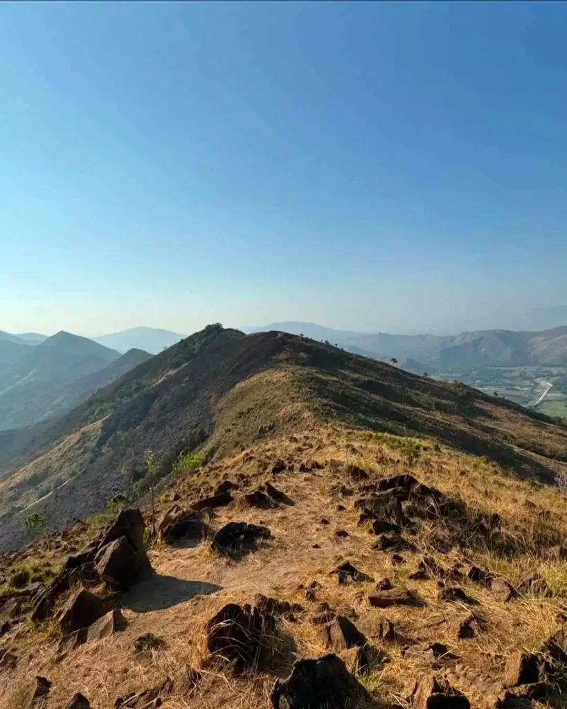
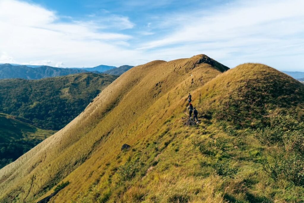
The climb begins after the kolong-kolong drops you at the trailhead. Early sections move through vegetation before opening up onto the grassy ridge — and once you’re on that ridge, there’s very little shade. The footing is a mix of compacted soil, loose scree near the upper sections, and patches of sharp cogon grass that brush against bare arms and legs if you’re not covered up.
The ascent takes most fit beginners 2 to 3 hours at a steady pace. It’s not technically demanding — no ropes, no exposed scrambling — but the heat on the open ridge in anything other than peak dry-season mornings will slow you down more than the gradient alone.
The Summit
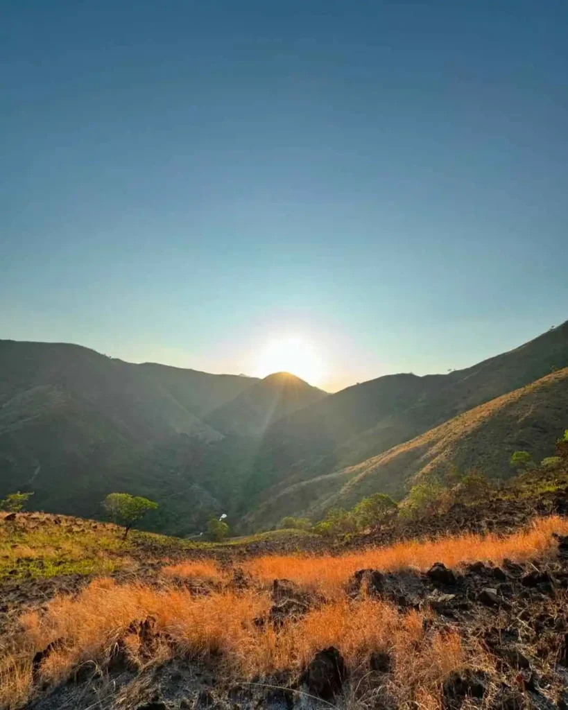
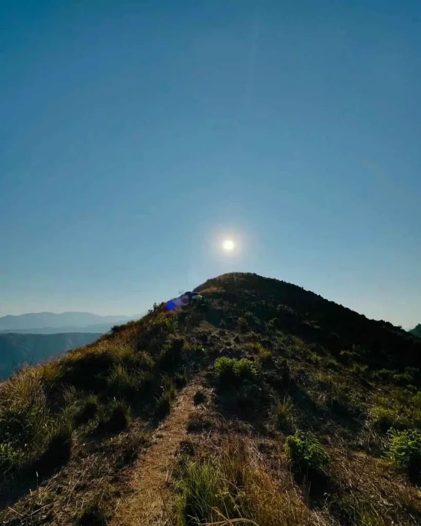
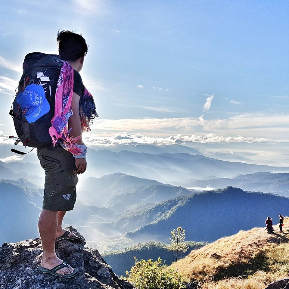
The summit at 573 MASL delivers what the approach promises: a wide, open view across the Zambales mountain ranges and, on a clear morning, the West Philippine Sea glinting in the distance. It’s the kind of panorama that feels disproportionately rewarding for a sub-600-meter peak, which is part of Mt. Mariglem’s appeal.
There’s no summit shelter or structure to speak of — just the view, the wind if you’re lucky, and the knowledge that the best part of the day is about to begin.
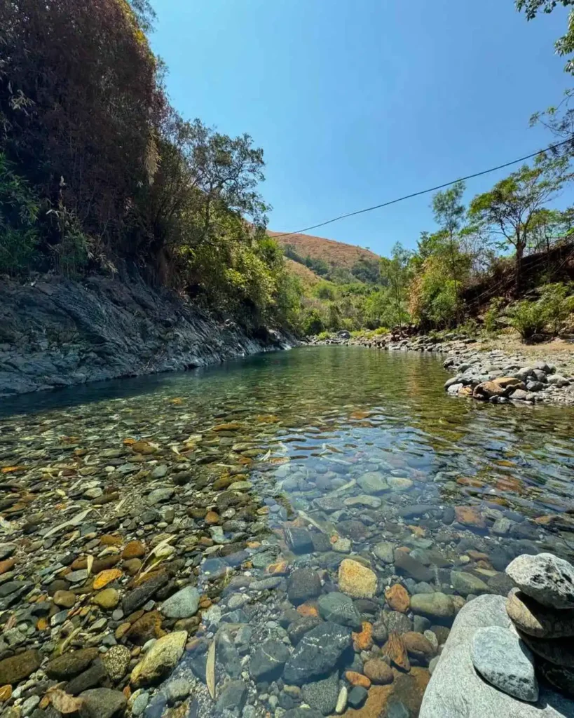
The Descent to the Rivers
The descent brings you down toward the rivers — Maligha and Agbobotilya are the main ones mentioned in itineraries, with Nilumabangan appearing in some routes. This is the section that makes Mt. Mariglem feel like more than just a ridge walk. By the time you reach the water, the heat of the descent has done its work, and the rivers are a genuine relief.
Important: River rocks are coated in biofilm and are slippery. Wear river sandals for the water crossing and watch your footing. After rain, river water can brown and rise quickly — if that’s the case when you arrive, skip the river section entirely. Flash flooding is a real risk in this terrain.
Best Time to Climb Mt. Mariglem
The best window for a Mt. Mariglem hike is December through February, when temperatures are lower, the sky tends to stay clear longer into the day, and the ridge section is bearable even at mid-morning.
March through May is significantly hotter on the exposed ridge, and while the mountain is technically climbable, the heat exhaustion risk rises meaningfully — as I found out in May 2026. If you’re set on climbing in the hot season, starting at 3:00 to 5:00 AM is not optional; it’s the margin that keeps the ridge section manageable. The goal is to summit before 8:00 AM and reach the rivers while temperatures are still tolerable.
Avoid scheduling the trail immediately after heavy rainfall. The rivers are part of the reward, but rain-swollen rivers and slick biofilm-covered rocks are not something a guide can protect you from if you’re already mid-crossing.
Budget Breakdown for Climbing Mt. Mariglem
| Expense | Cost (PHP) |
|---|---|
| Victory Liner bus (one-way, Manila to Cabangan) | ₱450–₱600 |
| Tricycle (Cabangan to Sitio Maporac) | ~₱300/trip |
| Kolong-kolong (Maporac to trailhead, per head) | ~₱100/pax |
| Registration/entrance fee | ₱50–₱100/pax |
| Guide fee (shared among up to 5 hikers) | ₱700–₱1,500/group |
| Food and water (bring most from Manila) | ₱200–₱400/pax |
| Return bus fare | ₱450–₱600 |
| Estimated total (group of 5, per pax) | ₱1,500–₱2,000 |
The ₱1,500–₱2,000 per person estimate works comfortably for a group of five sharing the guide fee and kolong-kolong. Solo travelers or pairs pay a higher effective cost because the guide fee doesn’t scale down proportionally. Budget higher if you plan to extend the trip with a beach stay in Zambales — there are plenty of Zambales tourist spots worth tacking on.
Safety Tips for Climbing Mt. Mariglem
Start before 6:00 AM at the absolute latest. The ridge section has no shade and the sun builds fast from mid-morning. An early start isn’t just comfort advice — it’s the single biggest factor in avoiding heat exhaustion on this trail.
Watch for cogon grass along the narrow ridge sections; long, lightweight pants or arm sleeves prevent the small cuts that accumulate over the course of a descent. On the descent itself, loose scree and trail dust are the primary footing hazard — slow, deliberate steps beat momentum every time.
At the rivers, test each step before committing weight and assume every submerged rock is slippery. If you arrive at the river and the water is turbid or noticeably higher than knee-level, skip the crossing entirely. No summit photo is worth a flash-flood injury. Have the emergency contacts saved before you leave: 0949 879 1342 (local booking/tourism), 0917 508 9672 (Cabangan municipal), 0964 315 4201 (Cabangan emergency), and national 911.
Mt. Mariglem Itinerary: Sample Day-Hike Schedule
A typical Mt. Mariglem DIY itinerary for a Manila-based group looks like this:
- 12:00 AM – 1:00 AM — Depart Manila via Victory Liner
- 5:00 – 6:30 AM — Arrive Cabangan, tricycle to Sitio Maporac
- 6:00 – 7:00 AM — Register, pay fees, meet guide, board kolong-kolong
- 6:30 – 7:30 AM — Arrive trailhead, begin ascent
- 9:00 – 10:00 AM — Reach summit (573 MASL), rest and take photos
- 10:00 – 11:30 AM — Descend to Maligha and Agbobotilya rivers
- 11:30 AM – 12:30 PM — River time, wash-up, snacks
- 1:00 – 2:00 PM — Return to Maporac, kolong-kolong back
- 2:30 – 3:00 PM — Depart Cabangan by bus
- 7:00 – 8:30 PM — Back in Manila
I had tapsilog at the jump-off before we set off — there’s a small eatery near the Maporac staging area, and eating a real meal before the climb rather than snacking on trail food made a noticeable difference in how I felt on the ridge. Don’t skip breakfast just because you’re in a hurry to start.
Nearby Attractions After Climbing Mt. Mariglem
Cabangan and the broader Zambales coast have enough to justify spending a full weekend rather than rushing back to Manila. The nearest beach areas along the Zambales coastline are within reasonable tricycle or van distance from Cabangan, and they’re significantly less crowded than the more popular Subic or San Antonio strips.
Some hikers combine the climb with a stop in San Felipe or San Antonio for seafood and beach time before heading home. If you want a fuller picture of what’s worth visiting in the area, the Zambales tourist spots guide is a solid starting point for planning the rest of your weekend. For those who want a bigger challenge after ticking Mt. Mariglem off the list, Mt. Tapulao is the province’s most demanding long hike and a natural next step.
What to Pack for Mt. Mariglem
| Item | Essential? |
|---|---|
| 2–3 liters of water minimum | Yes — non-negotiable |
| Electrolyte drinks or hydration salts | Yes |
| Trail shoes or rubber shoes with grip | Yes |
| Long pants or leggings (cogon protection) | Yes |
| Sun hat or cap | Yes |
| Sunscreen (SPF 50+) | Yes |
| Trekking poles | Strongly recommended |
| Rain jacket or light windbreaker | Yes |
| Headlamp with extra batteries | Yes (for early starts) |
| Dry bag or waterproof bag liner | Yes (for river crossings) |
| First-aid kit with blister plasters | Yes |
| Sandals or flip-flops (for river section) | Recommended |
| Snacks — rice meals, energy bars | Yes |
| Water purification tablets | Recommended |
| Fully charged phone + power bank | Yes |
| Cash (no ATMs near trailhead) | Yes |
For footwear, trail shoes with good rubber grip are the practical choice for both the loose descent and the slippery river rocks. Sandals or flip-flops packed separately are worth it for the river section, since soaking your trail shoes makes the hike back out significantly less comfortable.
Safety Tips for Climbing Mt. Mariglem
The main hazards on the Mt. Mariglem trail are heat exhaustion, dehydration, loose terrain on the descent, sharp cogon grass, slippery river rocks, and flash-flood risk after heavy rain. Most of these are preventable with preparation.
- Start before 6:00 AM — ideally 3:00–5:00 AM. Heat is the biggest hazard on this trail, not technicality.
- Carry at least 2–3 liters of water per person and start drinking before you feel thirsty. Electrolyte supplements are worth packing.
- Do not skip the guide — beyond being mandatory, guides know the descent route and river crossing points, which are less obvious than the ascent.
- Check weather before you go. If heavy rain hit the area in the 24–48 hours before your hike, the descent becomes significantly more dangerous and the rivers can flash-flood without warning. If river water turns brown or rises, abort the river crossing immediately.
- Wear long pants to protect against cogon grass cuts, which are surprisingly deep and slow to heal.
- Step carefully on river rocks — biofilm makes them as slippery as ice even in shallow water. A trekking pole helps here too.
- Keep emergency numbers saved offline: local tourism line 0949 879 1342, Cabangan municipal 0917 508 9672, emergency hotline 0964 315 4201, national 911.
For a broader perspective on mountain safety across the Philippines, the [mountains in the Philippines travel guide](https://lakbaypinas.com/mountains-in-the-philippines-travel-guide/) has useful preparation frameworks that apply to any beginner-level climb.
Frequently Asked Questions About Mt. Mariglem
How high is Mt. Mariglem, and is the elevation gain manageable for beginners?
Mt. Mariglem stands at 573 meters above sea level, with a net elevation gain of roughly 490–500 meters from a trailhead starting at about 80 MASL. For fit beginners, the gain itself is manageable — the real challenge is the heat on the exposed ridge, not the altitude.
How long does it take to hike Mt. Mariglem?
Most groups reach the summit in 2–3 hours from the trailhead. The full round-trip, including time at the rivers, typically runs 4–6 hours. The trail distance is approximately 4.5–6.2 km round-trip, depending on your exact route through the river section.
Is a guide mandatory for Mt. Mariglem, and how much does it cost?
Yes, a guide is mandatory under current local policy. The enforced ratio is 1 guide per 5 hikers. The published rate runs ₱700–₱1,500 per group per day — confirm the current figure when you pre-book, as this can change.
Can you do Mt. Mariglem as a day trip from Manila?
Yes. A typical DIY itinerary has you leaving Manila around midnight to 1:00 AM, registering in Sitio Maporac before dawn, reaching the summit by mid-morning, finishing at the rivers before noon, and returning to Manila by late afternoon. The total bus travel time is 4.5–6 hours one-way.
What are the water sources on the Mt. Mariglem trail?
There is no published potable spring on the ridge itself. Water access becomes available after the descent at the Maligha, Agbobotilya, and Nilumabangan rivers. Treat all river water before drinking — do not consume it untreated regardless of how clear it looks. Carry all the water you need for the ascent from the jump-off.
Final Verdict: Should You Climb Mt. Mariglem?
Mt. Mariglem earns a 4 out of 5 for fit beginners and a 4.5 out of 5 for intermediate hikers looking for a rewarding day trip from Manila with genuine views and a river payoff. The exposed, shadeless trail and loose descent keep it from being a true walk-in-the-park for beginners, but every challenge on this mountain is manageable with the right preparation, an early start, and enough water. If you’re building your hiking résumé in Zambales and want something that feels like a real mountain without committing to a multi-day expedition, Mt. Mariglem belongs on your list.
Pingback: Discover the Beauty of Mt. Mariglem: A Hiker's Guide to Zambales’ Hidden Gem
Thanks for sharing. I read many of your blog posts, cool, your blog is very good.
Pwede po makahingi number ng local Guide sa Mt Mariglem
Pingback: Mt. Mariglem DIY Guide: 2026 Itinerary & Budget (Zambales) - Dave's Travel Corner