Mt. Batolusong Quick Facts
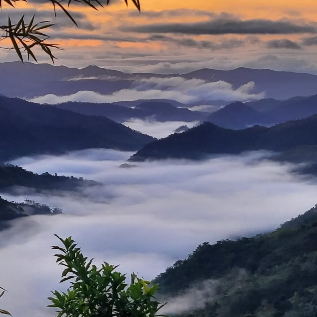
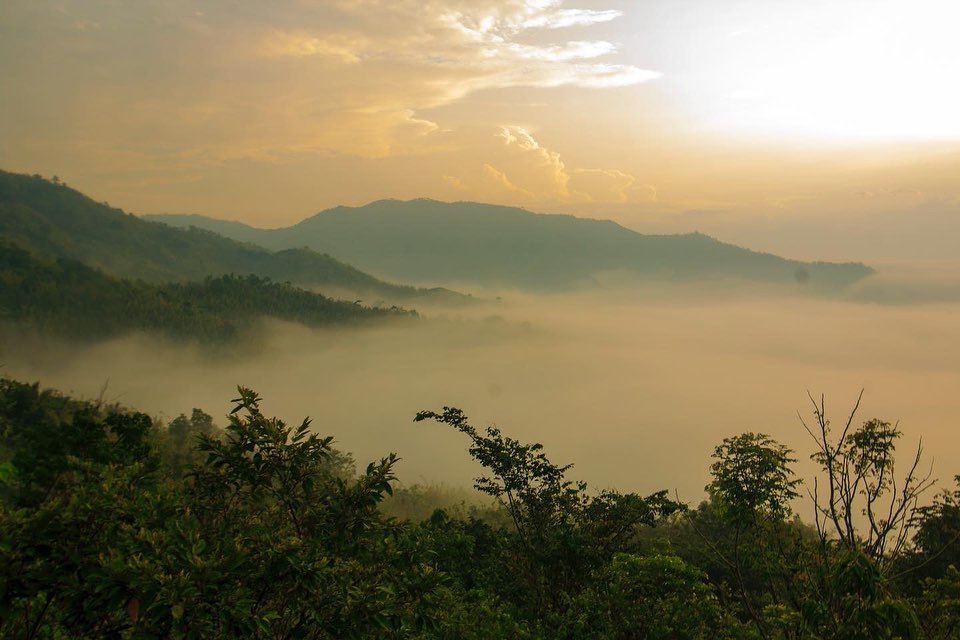
Mt. Batolusong is a minor climb (Difficulty 3/9) situated in Barangay San Andres, Tanay, Rizal. Rising to 883 MASL at Rangyas Peak, it is famous for its rolling “Batanes-like” grasslands and the “Sea of Clouds” phenomenon. The trek typically requires 3–4 hours back-to-trail. As of 2026, hikers must adhere to a strict 1:5 guide ratio and a total ban on single-use plastics.
Before you commit to the drive, here is the technical breakdown of the mountain.
-
Jump-off Point: Barangay San Andres Hall, Tanay, Rizal (Do not use the Batangasan/Kay-Ibon backdoor; it is prohibited).
-
Summit Elevation: 883 MASL (Rangyas Peak) / 645 MASL (Mapatag Plateau).
-
Days Required: 1 Day (Day Hike).
-
Trek Duration: 3 to 4 hours (Back-to-trail pace).
-
Terrain: Hard red clay (extremely slippery when wet), open grasslands, and Class 3 limestone scrambling near the summit.
-
Best Time to Summit: 05:30 AM to 07:00 AM (for the Sea of Clouds).
-
Mobile Signal: Spotty Smart/Globe signal at the summit; Dead spot at the jump-off.
The “Mud Factor” Warning
I cannot stress this enough: do not underestimate the red clay soil of Rizal. In the dry season (March–May), it is a dusty, hard-packed surface, but a single rain shower turns the first hour of the trail into a viscous slide.
I’ve seen hikers in standard running shoes struggle to find traction on the “Assault” section leading to Duhatan Ridge. I highly recommend wearing trail runners with at least 5mm lugs or bringing trekking poles to navigate the slick sections.
The 2026 Regulatory Update
Under the new “Resilient Tanay” framework, the Tanay Tourism Office is serious about carrying capacity. The 1:5 Guide Ratio (1 Guide for every 5 Hikers) is strictly enforced at the registration area. If you are a group of 6, you will be required to hire two guides—budget accordingly.
Introduction
Mt. Batolusong in Tanay, Rizal, remains the premier “Sea of Clouds” destination near Manila, featuring the rolling “Batanes-like” grasslands of Mapatag Plateau. However, the 2025 “Regenerative Tourism” overhaul has ended the era of unregulated hiking. This guide covers the new guide ratios, the plastic ban, and the strict 5:30 AM arrival window needed to catch the sunrise.
For years, we’ve called it the “Batanes of the East.” Standing on the windswept Mapatag Plateau at 645 MASL, staring out at the golden cogon grass, it’s easy to forget you are just 50 kilometers away from the chaos of Quezon City. But if you are planning a trip here in 2026, you need to know that the mountain has changed—not geologically, but administratively.
The “walk-in and climb” culture we were used to is effectively over. Following the rehabilitation closures in early 2025 and the subsequent reopening in October, Mt. Batolusong is now the pilot area for Project TRANSFORM. This is a massive collaboration between the DENR, Tanay LGU, and local stakeholders to shift from mass tourism to “Regenerative Tourism.”
What does this mean for us hikers? It means access is now treated as a privilege. The San Andres locals are stricter with the 1:5 guide ratio, and the “Green Fund” fees are non-negotiable.
I wrote this Mt. Batolusong DIY guide to help you navigate this new operational landscape. We’ll cover how to bypass the Cogeo Gate 2 transport bottleneck, why you need to bring a Nalgene instead of bottled water to avoid fines, and how to time your assault on Rangyas Peak to avoid the “sauna effect” of the lower forest.
Let’s get you to that Sea of Clouds responsibly. If you are looking for other cloud-chasing spots nearby, check out our list of 10 Must-Visit Sea of Clouds in Tanay, Rizal (2025).
Table of Contents
How to Go to Mt. Batolusong(Manila to Tanay)
To get to Mt. Batolusong from Manila, take a jeepney or UV Express from Cubao to Cogeo Gate 2. From the terminal near Cogeo City Mall, transfer to a jeep bound for “Sampaloc” and get off at Batangasan Junction. Finally, hire a tricycle to the Brgy. San Andres Hall. The total travel time is 2–3 hours and costs approximately ₱250 one-way.
Navigating the route to Tanay requires patience, especially with the transfer schedules. Here is the step-by-step breakdown using public transport.
Step 1: Cubao to Cogeo Gate 2
Head to the terminal area along Aurora Boulevard in front of Gateway Mall or near Puregold Cubao. Look for traditional jeepneys or UV Express vans with the signboard “Cogeo Gate 2” or “Padilla.”
-
Fare: Approximately ₱35 – ₱40.
-
Travel Time: 45 minutes to 1 hour (depending on traffic along Marcos Highway).
-
Drop-off: Cogeo Gate 2 (near the pedestrian overpass and City Mall).
Step 2: The Cogeo Bottleneck (Crucial Step)
This is where most DIY hikers get stuck. Walk towards the jeepney terminal near Cogeo City Mall and the Public Market. You need to find the jeepneys bound for “Sampaloc” or “Tanay (via Sampaloc).”
-
Fare: ₱45 – ₱50.
-
Travel Time: 45 minutes to 1 hour.
-
The “Sunrise” Problem: These jeepneys operate on a “fill-up” basis. The first trip often doesn’t depart until 4:00 AM or 5:00 AM.
-
My Advice: If you are chasing the 5:30 AM sea of clouds, you cannot rely on this first trip. You may need to negotiate a “pakyaw” (private charter) jeep if you are in a big group, or hire a tricycle from Cogeo (approx. ₱600 – ₱800) if you are running late.
Step 3: Batangasan Junction to San Andres
Tell the driver to drop you off at Batangasan Junction (sometimes called “Junction San Andres”). You will see a waiting shed and a line of tricycles or habal-habal (motorcycle taxis).
-
Transport: Tricycle or Habal-Habal.
-
Fare: ₱150 per tricycle (good for 3-4 pax) or ₱50 per head for habal-habal.
-
Distance: It’s a 2-3 kilometer ride on a paved road to the jump-off.
-
Final Stop: Barangay San Andres Hall (Registration Area).
For Private Vehicles
If you are driving, navigation is straightforward via the Marikina-Infanta Highway (Marcos Highway).
-
Set Waze or Google Maps to “Barangay San Andres Hall, Tanay.”
-
Warning: Do not pin “Kay-Ibon Falls” or enter via the highway side trails. This is considered “backdoor” hiking and is prohibited under the 2026 ordinances. You must pass through the official barangay registration.
-
Parking: Secure parking is available near the Barangay Hall for ₱50 – ₱100.
Pro Tip: If you have extra time after the hike, the famous Pililla Wind Farm is just a scenic drive away.

Mt. Batolusong Hiking Experience: Mud, Grass, and Rock
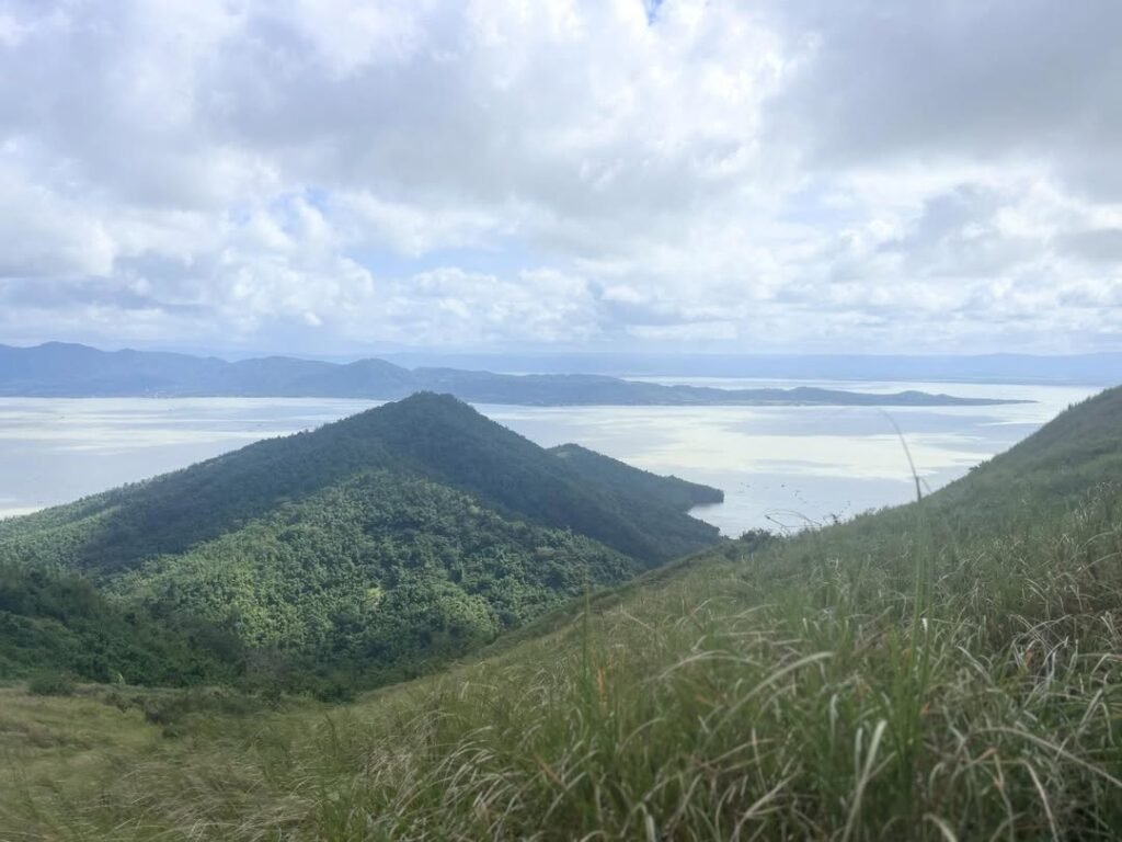
The Mt. Batolusong trail is a mix of three distinct environments: agricultural lowlands, humid forest, and open limestone summits. It starts with a flat trek through rice paddies, shifts into a steep, humid forest ascent known as “The Sauna,” and breaks out onto the windy grasslands of Mapatag Plateau (645 MASL). The final push to Rangyas Peak (883 MASL) requires Class 3 scrambling over sharp limestone rocks. Warning: The red clay path is incredibly slippery when wet.
Phase 1: The Warm Up & “The Sauna”
The trek begins at the Barangay San Andres Hall (approx. 200 MASL), weaving through a quiet community before hitting the local rice fields. While the terrain here is flat, walking on the narrow pilapil (rice dikes) requires balance.
-
Hazard Warning: If it rained the night before, these clay dikes become like greased balance beams. I’ve seen more hikers slip into the muddy paddies here than on the actual summit.
After about 45 minutes, you leave the open fields and enter the secondary forest line. This is where the “Assault” begins. The canopy traps the heat, creating a humid microclimate we call “The Sauna Effect.” You will sweat profusely here, so pace yourself to avoid early dehydration before you even reach the ridge.
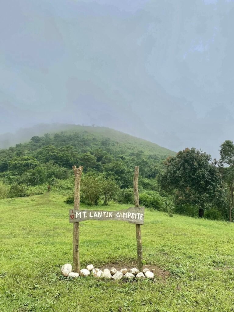
Phase 2: Duhatan Ridge & Mapatag Plateau
At around 500 MASL, the tree line breaks abruptly, and you are hit with fresh air at Duhatan Ridge. The view opens up completely, revealing the “Batanes-like” rolling hills that made this mountain famous.
From the ridge, it’s a scenic walk to the Mapatag Plateau (645 MASL). This is the prime spot for the Sea of Clouds and where most campers pitch tents. The wind here can be fierce—strong enough to snap cheap tent poles—so if you plan to stay long, bring a windbreaker. (If you enjoy these kinds of rock formations, you should also check out our Guide to Nagpatong Rock Formation, which is nearby.)
Phase 3: Rangyas Peak (The Summit Push)
The final leg to Rangyas Peak (883 MASL) changes the game entirely. The soft grassy trail disappears, replaced by jagged limestone karst formations.
This section involves Class 3 scrambling, meaning you will need to use your hands to pull yourself up sharp rock faces. The limestone is abrasive, so gloves are recommended if you have sensitive hands.
My Honest “Mud Factor” Experience: On my last hike here in October 2025, it rained midway through our descent. The red laterite soil turned into a peanut-butter-like sludge that clogged the soles of my hiking boots instantly.
I deeply regretted wearing heavy boots that day. My friend, who was wearing trail runners with 5mm lugs, had a much easier time shedding the mud. If you have the option, prioritize traction over ankle support for this specific mountain.

Mt. Batolusong Sample Itinerary: Chasing the Sunrise
For the best chance of seeing the Sea of Clouds, you must leave Metro Manila by 01:30 AM. Aim to arrive at Brgy. San Andres by 03:00 AM for mandatory registration. Begin trekking no later than 03:30 AM to reach Mapatag Plateau by 05:30 AM. Summit Rangyas Peak by 08:00 AM and descend by 9:00 AM to avoid midday heat.
This specific itinerary, nicknamed the “Chaser of Dawn,” is designed for private vehicle owners or groups hiring a private jeep/van. If you are commuting via Cogeo, you likely won’t arrive until sunrise, missing the cloud formation.
The “Chaser of Dawn” Timeline
| Time | Activity | Notes |
| 01:00 AM | Assembly at Cubao | Meet near Gateway or Farmers Market. |
| 01:30 AM | Depart for Tanay | Via Marcos Highway. No traffic at this hour. |
| 03:00 AM | Arrive at Brgy. San Andres | Secure parking (₱50) & Register at Barangay Hall. |
| 03:30 AM | Start Trek | Headlamps are mandatory. The trail is pitch black. |
| 05:00 AM | Reach Duhatan Ridge | First light begins to appear. |
| 05:30 AM | Arrive at Mapatag Plateau | Prime Window for Sea of Clouds & Sunrise. |
| 07:00 AM | Resume Trek to Summit | The trail shifts from grass to rock. |
| 08:00 AM | Summit Rangyas Peak | Enjoy 360-degree views of the Sierra Madre. |
| 09:30 AM | Start Descent | Option: Divert to Kay-Ibon Falls trail. |
| 11:00 AM | Kay-Ibon Falls | Swimming and early Lunch (Packed Lunch recommended). |
| 01:00 PM | Return to Jump-off | Wash up at local showers (₱50). |
| 03:00 PM | Depart for Manila | Avoids the rush hour traffic on Marcos Highway. |
Why the Early Start?
I cannot emphasize the heat factor enough. Mapatag Plateau has zero tree cover. If you start your hike at 06:00 AM (standard public transport arrival), you will reach the open grasslands by 08:30 AM.
By that time, the sun is punishing, and the humidity from the ground evaporates, killing the chance of a sea of clouds. We learned this the hard way on a “Leisure Hike” where the heat index hit 38°C by mid-morning. Stick to the 03:30 AM start time—your skin will thank you.
Mt. Batolusong Budget Breakdown (2026 Estimates)
A safe DIY budget for a Mt. Batolusong day hike is ₱1,000 – ₱1,200 per person. This covers roundtrip transport from Cubao (approx. ₱500), the mandatory shared Guide Fee (₱800 for a group of 5), and the updated Ecological Fees (₱150) mandated by the “Resilient Tanay” project. Always carry extra cash for the ₱50 shower fee and meals, as there are no ATMs at the jump-off.
If you haven’t hiked in Tanay since the 2025 reopening, you will notice a slight increase in fees. This is due to the “Green Fund” implementation under the Project TRANSFORM initiative, which directs revenue toward reforestation and waste management in Barangay San Andres.
Here is the realistic expense breakdown for a Group of 5 Hikers coming from Cubao.
The “Share-It” Budget Table (Per Person)
| Expense Item | Est. Cost (PHP) | Notes |
| Jeep/UV: Cubao to Cogeo | ₱80 (RT) | ₱40 one-way fare. |
| Jeep: Cogeo to Batangasan | ₱100 (RT) | ₱50 one-way fare. |
| Tricycle: Junction to San Andres | ₱100 (RT) | Share of ₱150/trike (3 pax max). |
| Ecological & Green Fee | ₱150 | Mandatory upon registration. |
| Guide Fee (Shared) | ₱160 | Share of ₱800 (Strict 1:5 Ratio). |
| Shower / Toilet Fee | ₱50 | Use of facilities at Brgy. Hall. |
| Food / Trail Water | ₱300 | Packed lunch + post-hike meal. |
| TOTAL ESTIMATE | ₱940 – ₱1,000 | Safe buffer: Bring ₱1,500. |
The “Hidden” Costs & Honest Warnings
While the table looks straightforward, reality on the ground can differ. Here are the financial pain points I’ve encountered:
-
The Tricycle Premium: If you arrive at Batangasan Junction at 3:00 AM, tricycle drivers often ask for a “special trip” rate since they don’t have return passengers. Expect to pay ₱200 – ₱250 per trike instead of the standard ₱150 if you don’t haggle politely.
-
Guide Fee Standardization: Please do not haggle with the guides. The ₱800 rate is a standardized wage set by the local association to support families transitioning away from charcoal-making livelihoods.
-
Cash is King: There are absolutely zero ATMs in Barangay San Andres. The last reliable ATM is at Cogeo City Mall. Withdraw everything you need before you ride that jeep to Sampaloc.
Mt. Batolusong Important Requirements (The New Normal)
As of 2026, strict “Regenerative Tourism” protocols are in effect for Mt. Batolusong. A total ban on single-use plastics (PET bottles, sachets) is enforced with bag inspections at registration. Walk-ins are highly discouraged on weekends; prior coordination with the Tanay Tourism Office is recommended. The mandatory guide ratio is strictly 1:5.
The days of showing up with a plastic bag of groceries and a case of water are over. Under the Project TRANSFORM initiative, Tanay has pivoted to a “High Value, Low Impact” tourism model. Here is what you need to prepare to avoid being denied entry.
1. The Strict “Zero Waste” & Plastic Ban
The Tanay LGU and Barangay San Andres now enforce a “No Single-Use Plastic” ordinance. This is not just a suggestion; it is an entry requirement.
-
Prohibited Items: Disposable water bottles (Nature’s Spring/Wilkins type), plastic straws, styrofoam containers, and single-use coffee/shampoo sachets.
-
The Inspection: Barangay tanods (guards) often conduct spot checks on bags at the registration area.
-
The Solution: You must decant your trail food into reusable containers (Tupperware/LocknLock) and carry water in reusable bladders or rigid bottles (e.g., Nalgene or Hydroflask).
-
Trash Policy: “Pack In, Pack Out.” You are required to bring down every piece of trash you generate, including used toilet paper and wet wipes.
2. Guide Ratio & Capacity (1:5 Rule)
To ensure safety and provide equitable income for the local guide association, the ratio is non-negotiable.
-
The Rule: 1 Guide for every 5 Hikers.
-
The Math: If you are a group of 6 people, you are legally required to hire 2 Guides.
-
Why? This policy prevents guide fatigue and ensures that in an emergency (like a slip on the clay trail), there is enough manpower to assist.
-
Pain Point: Do not try to bribe or negotiate this with the desk officer. It is a municipal ordinance, and arguing simply delays your trek.
3. Booking & Coordination
While Mt. Batolusong technically accepts walk-ins, the daily carrying capacity is capped to prevent trail erosion. On weekends, slots fill up by 4:30 AM.
-
Coordination: For large groups (10+), message the Tanay Tourism Office on Facebook at least 3 days prior.
-
Contact Number: You can reach the local tourism satellite at 0998-988-1590 or (02) 8655-1773 (Office Hours).
-
Health Check: A medical certificate is rarely asked for day hikes, but they will require you to sign a waiver declaring you are fit to climb.
What I Wish I Knew Before Hiking Mt. Batolusong
The red clay trail of Mt. Batolusong is notoriously slippery when wet; trail runners with deep 5mm lugs are safer than standard hiking boots. There is virtually zero shade on the Mapatag Plateau, making sun protection vital. Crucially, public transport from Cogeo Gate 2 is unreliable between 1:00 AM and 4:00 AM, making private van rentals the smarter choice for sunrise hikes.
This is the section where I drop the glossy travel magazine tone and give you the raw reality. I’ve made these mistakes so you don’t have to.
The “Cogeo Trap” (Public Transport Nightmare)
If you are planning a DIY sunrise hike, do not rely on the Cogeo jeepneys between 1:00 AM and 3:00 AM.
During my first solo attempt, I arrived at the Cogeo City Mall terminal at 2:00 AM, expecting a quick transfer to Sampaloc. Instead, I sat on a metal bench for two hours because the jeepneys strictly follow a “fill-up” system and the first trip didn’t depart until 4:15 AM.
-
The Result: I started trekking at 6:00 AM and missed the sea of clouds entirely.
-
The Fix: If you are a group, hire a private jeep (“pakyaw”) immediately upon arrival at Cogeo Gate 2 or rent a van from Cubao to control your schedule.
The “Sticky” Mud Reality
The soil in Tanay isn’t just mud; it is laterite red clay. When it rains—which happens frequently in the Sierra Madre—this soil turns into a peanut-butter-like substance that sticks to everything.
-
Footwear Mistake: I wore heavy hiking boots with shallow treads. The clay clumped onto the soles, turning my boots into heavy, slippery weights with zero traction.
-
Gear Fix: Wear trail runners with aggressive lugs (at least 5mm depth).
-
Pro Tip: Bring trekking poles. On the descent from Rangyas Peak, they are the only things stopping you from sliding 10 feet down the trail on your butt.
Water Safety: Don’t Trust the “Bukal”
Local guides often point to natural springs (bukal) near the forest line as potable water sources. Do not drink this directly.
While the water looks clear, the lower slopes of Mt. Batolusong are surrounded by active rice paddies and vegetable plots. The risk of fertilizer or pesticide runoff is real.
-
My Protocol: I strictly treat all water sources here using a Sawyer Mini filter or Aquatabs.
-
Hydration Plan: Carry at least 2 Liters of your own clean water from Manila or buy distilled water at the 7-Eleven in Cogeo before heading up.
Conclusion
Mt. Batolusong remains the premier DIY day hike near Metro Manila for 2026, offering the famous “Sea of Clouds” just 2 hours from Cubao. However, a successful summit now requires strict adherence to Tanay’s “Regenerative Tourism” protocols: a mandatory 1:5 guide ratio, payment of the “Green Fund” ecological fee, and a total ban on single-use plastics.
After witnessing the transformation of Tanay over the last few years, I can confidently say that the new rules are worth it. The closures in 2025 under Project TRANSFORM have allowed the trails to recover, making the grasslands of Mapatag Plateau more vibrant than I’ve seen in a decade.
The days of cheap, unregulated “mass tourism” are gone. Accessing the Sierra Madre is now a privilege that comes with responsibility. When you pay that ₱800 guide fee, know that you are directly supporting a local family in Barangay San Andres transitioning away from charcoal making.
My Final Reminders for 2026:
Time it right: Be at Duhatan Ridge by 05:30 AM; otherwise, you’re just hiking in the heat.
Pack it out: The barangay officials check bags. Don’t risk a fine for a ₱20 plastic bottle.
Respect the queue: If the Tourism Office says the trail is full, respect the carrying capacity.
The “Batanes of the East” is still breathtaking, but it demands more respect than before. Respect the locals, leave no plastic, and enjoy the sea of clouds.
If you are looking to explore more of this beautiful province, don’t miss our comprehensive 14 Must-Visit Tanay Rizal Tourist Spots Guide or the wider 17 Must-Visit Rizal Tourist Spots Guide. And for a more spiritual side trip, check out our Guide to Regina RICA.
Ready to hike? Share this guide with your hike squad and start planning your 2026 assault!
Frequently Asked Questions (FAQ)
Mt. Batolusong is generally beginner-friendly (Difficulty 3/9), though the open-trail heat can be exhausting. Mobile signal (Smart/Globe) is reliable only at the summit, not the jump-off. Walk-ins are risky on weekends due to strict 2026 carrying capacity limits. Swimming at Kay-Ibon Falls is allowed, but water flow is minimal from March to May. Showers are available at the Barangay Hall for ₱50.
Here are the specific answers to the questions I get asked most often in our community group chats.
Is Mt. Batolusong actually beginner-friendly?
Yes, but do not underestimate the heat. While the technical difficulty is rated 3/9 (Minor Climb), the initial hour involves a steep, humid ascent through the forest that leaves many first-timers catching their breath. Once you reach Duhatan Ridge, you are exposed to direct sunlight for the rest of the hike.
-
My Advice: If you are a total beginner, start your hike by 04:00 AM to beat the midday sun. For absolute beginners, you might also consider Treasure Mountain, which requires less trekking. Check our Ultimate Guide to Treasure Mountain.
Is there a mobile signal?
The connectivity is tricky.
-
Jump-off (Brgy. San Andres): Almost a complete dead spot for both Smart and Globe. Do not expect to coordinate meetups or grab rides via apps here.
-
The Summit (Rangyas Peak): Surprisingly strong 4G/LTE signal is often available. This is where most hikers post their “Sea of Clouds” stories in real-time.
Are walk-ins allowed under the 2026 rules?
Technically, yes, but I strongly advise against it for weekends. The Tanay Tourism Office strictly enforces a daily carrying capacity to protect the trail.
-
The Risk: If you arrive at 06:00 AM on a Saturday, you might be turned away or made to wait for hours until a guide becomes available.
-
The Fix: Secure your slot by messaging the Tanay Tourism Facebook page at least 3 days in advance.
Can we swim at Kay-Ibon Falls?
Yes, you can, but manage your expectations based on the season.
-
Wet Season (June – October): The falls are powerful and perfect for a cold dip.
-
Dry Season (March – May): The flow reduces significantly, sometimes to just a trickle. It’s still refreshing, but don’t expect a roaring cascade. If you are chasing waterfalls specifically, I highly recommend visiting Daranak Falls instead. See our Ultimate Guide to Daranak Falls.
Are there restrooms and showers?
Yes, the Barangay San Andres Hall has a designated shower complex for hikers.
-
Cost: ₱50 per person for a shower; ₱10 – ₱20 for toilet use.
-
Warning: The queues get incredibly long between 12:00 PM and 2:00 PM as day hikers descend.