Mt. Tagapo is a 438-meter beginner-friendly day hike on Talim Island in Binangonan, Rizal, accessible by bangka from Pritil Port. The trail is roughly 6.43 km round-trip, takes 2 to 2.5 hours to summit, and costs under ₱1,500 all-in for a solo hiker. The real challenge is logistics — not the mountain itself.
Mt. Tagapo Quick Guide
| Detail | Info |
|---|---|
| Mountain | Mt. Tagapo (a.k.a. Mt. Susong Dalaga) |
| Location | Talim Island, Binangonan / Cardona |
| Province | Rizal, Calabarzon |
| Elevation | 438 MASL (1,437 ft) |
| Difficulty | 2/9 — Minor Climb |
| Jump-off | Barangay Janosa, Talim Island |
| Best Season | November to February |
| Trek Time | 2–2.5 hrs ascent; 1.5 hrs descent |
| Registration | Barangay Janosa Hall |
| Campsite | Designated area 10–15 min below summit |
Table of Contents
Where Is Mt. Tagapo Located?
Mt. Tagapo, also known as Susong Dalaga, is a conical peak on the lake island of Talim on Laguna de Bay — the largest lake in the Philippines. The mountain ridge stands at 438 meters (1,437 feet) in elevation, making it the highest point of Talim Island.
The peak falls under the respective jurisdictions of the towns of Binangonan and Cardona in Rizal province, Calabarzon region. For hikers, this distinction barely matters: Mt. Tagapo is most commonly accessed through Barangay Janosa in Binangonan, and for most readers, the Janosa side is the only route that matters because it is the standard access point for normal DIY and guided day hikes.
The island is volcanic in origin and forms the southwest rim of the Laguna Caldera. That geological context explains the conical summit shape — the same shape that gave the mountain its Tagalog name. The peak is also locally known as Bundók Susong Dalaga (literally, “mount maiden breast”), due to its conical shape.
What makes this mountain unusual among Rizal peaks is the access itself. Unlike its neighbors in Tanay, this mountain sits on an island village called Talim in the middle of a lake. You don’t just drive to the jump-off — you cross Laguna de Bay first.
How to Get to the Mt. Tagapo Jump-off Point
Getting to Mt. Tagapo’s jump-off at Barangay Janosa requires three separate legs of travel from Manila.
By Public Transport (Recommended):
Ride a UV Express van from the terminal in front of Starmall EDSA-Shaw Boulevard going to Binangonan or Cardona. The UV Express fare from EDSA Shaw going to Binangonan highway is around ₱100, and a tricycle ride to Binangonan Port costs about ₱20 per person.
From Cubao, the route is slightly different. From Cubao, ride a jeepney beside the Farmers Market or Ali Mall going to Binangonan, Rizal, and tell the driver to drop you at Pritil Port.
Once at Pritil Port, the lake crossing begins. The island can be reached by taking a boat ride from Pritil Port in Binangonan. Boats only leave once they’ve gathered enough passengers, so there’s no fixed departure time. The boat ride from Binangonan Port (Pritil) to Barangay Janosa is ₱65 and covers a two-way trip.
The boat ride to Brgy. Janosa takes about one to one and a half hours due to the numerous stops at different island barangays along the route. Make sure you alight at the right stop.
By Private Vehicle:
Public transportation to the jump-off point can be a hassle. If you have your own service, you can opt to drive to Binangonan Port and rent a private boat (approx. ₱1,500–₱2,000) for a faster crossing. Parking at the fish port is possible — ask the locals when you arrive.
Boat Schedule:
Boats going to Talim Island are available starting 5AM until 6PM depending on the number of passengers. Boats from Talim Island going back to the mainland are available as late as 5PM–6PM. Always confirm the last return boat time directly with the boatmen on the day of your hike.
I left Manila at 4:30 AM on a Sunday in June 2026 and reached Pritil Port by 6:15 AM. The bangka was rolling by 7:00 AM. Starting that early is not a suggestion — it’s the safest plan given the boat schedule constraints.
For more beginner-friendly mountain options near the capital, see this guide to beginner-friendly minor climbs in the Philippines.
Permits, Fees, and Guide Requirements at Mt. Tagapo
Registration and a local guide are required before climbing Mt. Tagapo.
Registration and getting a local guide are required before climbing Mt. Tagapo for safety purposes. You will secure a local guide at the barangay hall of Barangay Janosa, Talim Island.
From the port, it only takes a brief walk to the registration area near the barangay basketball court. The whole process takes under 15 minutes.
Current fees:
Before going up to the mountain, you register at the barangay hall for an environmental fee of ₱50 per head, and the tour guide fee is ₱500 for a maximum of 5 persons per guide. The overnight fee is ₱1,000, and the environmental fee is ₱40. Note that day hike and overnight fee structures may differ — confirm with the barangay at registration.
No online pre-registration or DENR permit is required for this hike. This is a barangay-managed trail. DENR official website can confirm if any national-level protected area rules apply to Talim Island in the future, but as of this writing, registration at Brgy. Janosa Hall is the only formality needed.
Guides follow a queuing system — booking a guide in advance is not encouraged since they follow a sequence to be fair to all of them. Just show up, register, and the next available guide will be assigned to your group.
What Is the Mt. Tagapo Trail Like?
The trail is well-established, manageable for beginners, but with a genuinely demanding upper section that earns its reputation. Here’s how each stage breaks down:
Stage 1: Barangay to Forest Entry (0–1 km)
Difficulty: 1/5 — The hike begins on a cemented path through the barangay, then transitions into a flat, shaded dirt trail. No elevation gain yet.
The trail begins with a cemented path that cuts through a residential area and a primary school’s backyard. You pass a few sari-sari stores here — buy water if you haven’t already. There are no vendors beyond this point.
Stage 2: Lower Forest — Bamboo and Mixed Trees (1–2.5 km)
Difficulty: 2/5 — Long, mild ascents over rocky and packed-earth terrain. Bamboo canopy provides shade. Footing is manageable in dry conditions, slippery in rain.
From the flats, you slowly cover slopes with long, mild ascents and descents over a rugged path. This goes on for about 10 minutes at a stretch. The ascent is gradual with some parts moderate. Most parts of the trail are shaded and you’ll see lots of bamboo trees.
There are two contrasting trails from Barangay Janosa to the summit. The first trail is covered with a bamboo forest. The second is an easier, open trail in grassland and farmland with more flat ground than moderate ascents. I took the bamboo forest trail. It’s shadier but more demanding.
Stage 3: Upper Forest to Campsite (2.5–2.9 km)
Difficulty: 3/5 — Steeper, sustained ascents with some sections close to 60 degrees. Rocky footing. You feel the climb here.
Deep within the forest, the real challenge begins. You face long ascents, often steep, along rocks and soft earth. Despite the beginner classification, the trail includes uneven rocks, a slippery path due to mud, and a 60-degree ascent.
This is where I stopped twice to catch my breath. The June heat was real — full sun and no wind at this elevation. I had two liters of water and was grateful for every sip.
Stage 4: Campsite to Summit (2.9–3.2 km)
Difficulty: 3/5 — Fully exposed cogon grass slope with no shade. Trail is narrow. The grass at 5–6 feet tall can whip your face and arms. Wind at the top provides some relief.
You have about 20 additional minutes to reach the summit through tall, swaying cogon grass that can whip your face if you are not careful enough. Guides are required to bring an itak (machete) to help keep the overgrowth from covering the hikers’ paths.
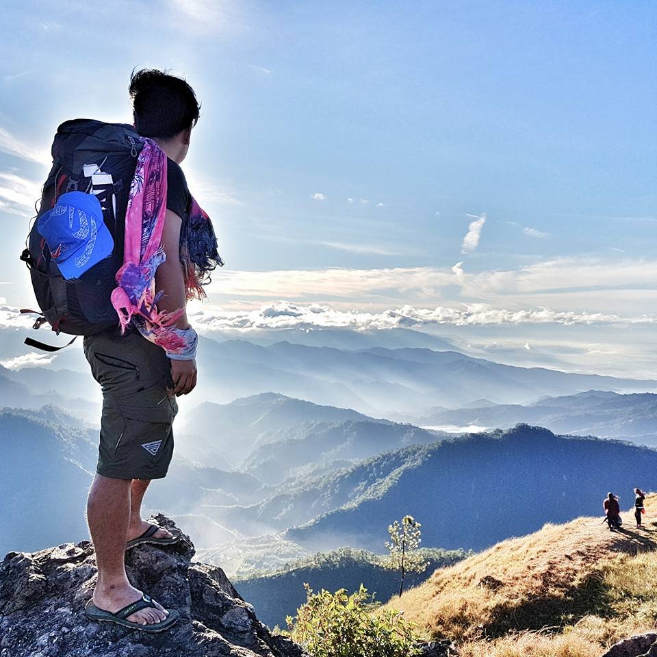
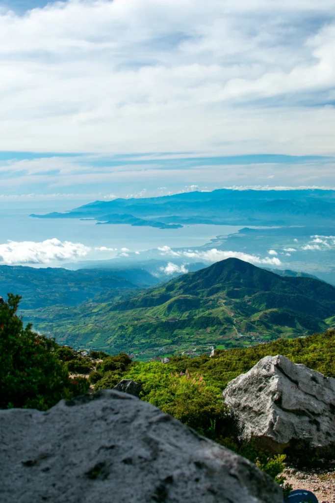
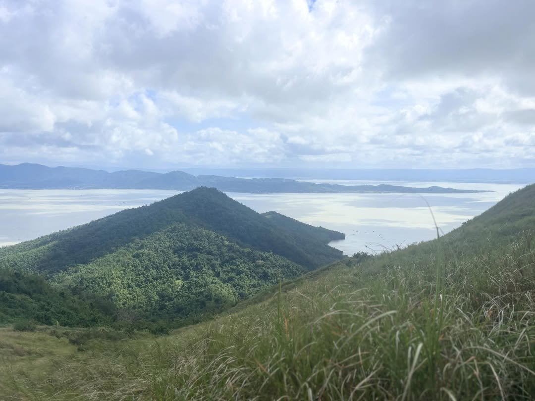
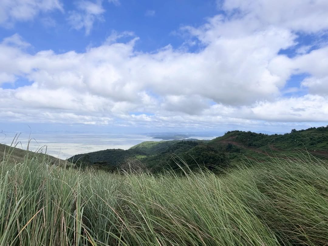
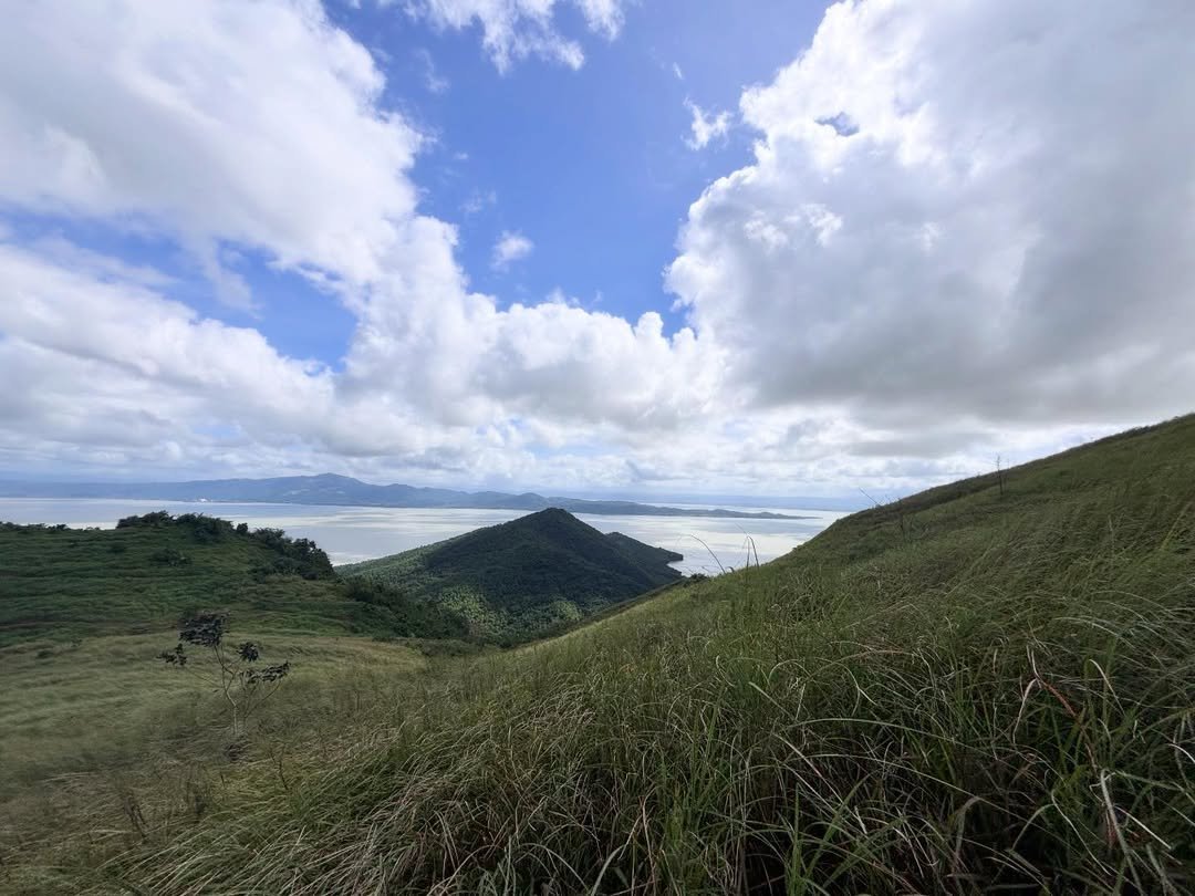
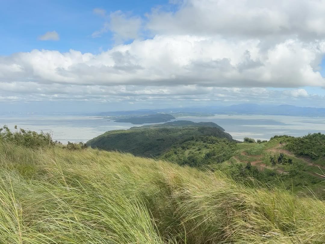
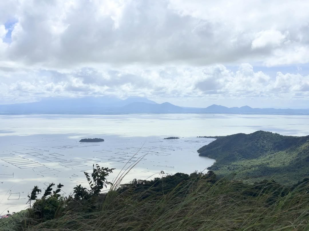
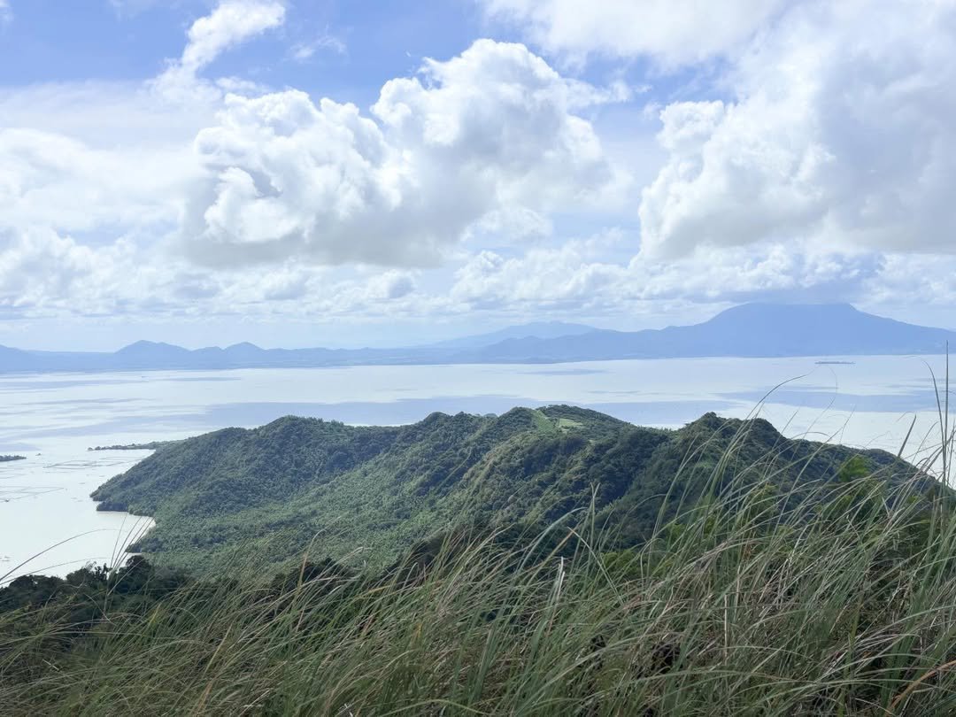
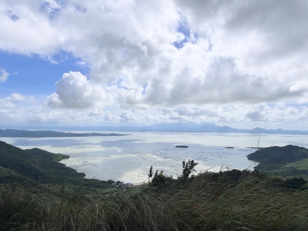
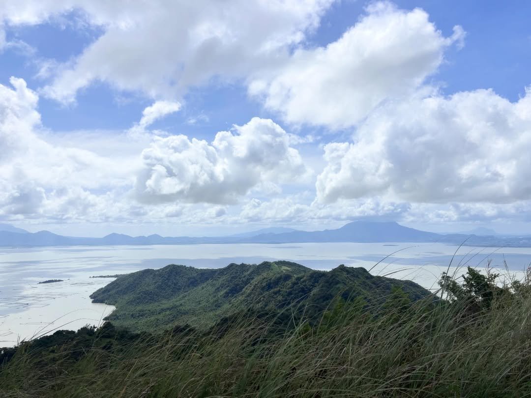
The summit is a flat portion of the mountain apex, with signage indicating the mountain’s name and the MASL. At the summit, you can see the 360-degree view of the majestic Laguna de Bay, several fishpens, moving ferry boats, the high buildings of Metro Manila like Makati, Taguig. From the campsite, hikers can admire views of Laguna de Bay and Metro Manila’s skyline before continuing to the summit, where panoramic vistas include the Pillila Windmills and distant mountain ranges like Makiling and Cristobal-Banahaw.
At the top, I stood alone for twenty minutes — no other group. The view of the fishpens spread across the lake below, with the Makati skyline faintly visible to the northwest, was worth every wet-season step.
There is also a large hole dug near the summit. There is a legend that buried treasure lies at the summit of Mt. Tagapo. This has now been cordoned off and any further digging has been banned on Talim Island.
Descent: The descent is simple in dry conditions, but after rain, the upper trail can turn into a muddy chute. Trekking poles are a good idea in the wet season because footing becomes much less forgiving.
Is Mt. Tagapo Good for Beginners?
Yes — Mt. Tagapo is one of the most beginner-appropriate hikes near Manila, with important caveats.
The trail classification in Mt. Tagapo is well established, easy to navigate, and has the perfect combination of moderate ascent and some flats in between. It is perfect for newbies and kids.
The caveats matter. Mt. Tagapo is a beginner-friendly minor climb on Talim Island in Rizal, but it is not a carefree late-start hike. The trail itself is manageable, yet the real difficulty comes from heat exposure, no reliable water source, and a boat-dependent return that can ruin your day if you move too slowly or start too late.
There are no blood leeches (limatik) in Mt. Tagapo, which is a real bonus compared to other Rizal mountains. The trail is not technical — no ropes, no river crossings.
For children: kids aged 7 and above can manage the trail with adult supervision and proper preparation. Expect them to need frequent rest stops in the upper section.
If this is your first ever mountain, also check out nearby hikes covered in our Rizal tourist spots guide to plan a full weekend.
Best Time to Climb Mt. Tagapo
The best months to hike Mt. Tagapo are November through February.
Mt. Tagapo is generally best climbed during the drier months because access, footing, and boat logistics are usually more predictable. Even then, the dry season can be harsher on the body because the exposed upper slope becomes brutally hot. So the sweet spot is the cooler dry season — November through February — when temperatures are lower and the sky is clear enough for good summit views.
March to May (peak summer): Hot and intensely sunny. If you’re hiking in the summer season, it’s highly recommended to bring an umbrella because the Mt. Tagapo summit has no shade and is very exposed to the sun. The lake views are sharp, but you will suffer on the exposed upper slope.
June to October (wet season): According to local tour guides, during the wet season the trail becomes difficult and very muddy. The coast guard may also cancel the boat ride if the weather is too bad. A typhoon can strand you on the island, making wet season hikes riskier in logistics than trail difficulty.
I climbed in June 2026 on a sunny day. The summit was rewarding, but the heat was real. I was on top by 9:30 AM and already sweating through my shirt. Had I started an hour later, the upper cogon section would have been brutal. Early starts matter most in summer and early wet season.
The peak visitor season is November to February. If you want the trail to yourself, aim for a weekday in January or early December. For nearby views of sea clouds in the Rizal region, also check out this guide to Tanay sea of clouds spots.
Budget Breakdown for Climbing Mt. Tagapo
A solo day hike from Metro Manila can be done for under ₱1,500.
| Expense | Cost (PHP) |
|---|---|
| UV Express / jeepney to Binangonan | ₱80–₱120 |
| Tricycle to Pritil Port | ₱20 |
| Bangka fare (round trip) | ₱65–₱130 |
| Registration / Environmental fee | ₱40–₱50 |
| Guide fee (shared by group, up to 5 pax) | ₱500 |
| Food and water (buy before boat) | ₱150–₱300 |
| Total (solo hiker, shared guide) | ₱855–₱1,100+ |
| Total (solo with private guide) | ₱1,200–₱1,500 |
Fees verified from multiple sources as current planning ranges. Fees, boat operations, and local admin processes can change without much notice — treat these figures as current planning ranges and verify locally before your hike.
For context on other nearby mountains to pair this trip with, see our Mt. Sembrano hike guide— an Mt. Tagapo vs Mt. Sembrano twin dayhike is a topic worth considering if you want to maximize a full Rizal weekend.
What to Pack for Mt. Tagapo
| Item | Essential? |
|---|---|
| At least 2 liters of water | Yes — no sources on trail |
| Packed lunch and trail snacks | Yes — no vendors past barangay |
| Trekking shoes or trail runners | Yes — rocky and muddy sections |
| Long-sleeved shirt or UV jacket | Yes — sun exposure on upper trail |
| Hat or cap | Yes |
| Sunscreen (SPF 50+) | Yes |
| Trekking poles | Recommended in wet season |
| Insect repellent | Recommended |
| Rain jacket or poncho | Yes in wet season |
| Headlamp | If starting before dawn |
| Small first aid kit | Yes |
| Trash bag | Yes — Leave No Trace |
There are no stores nor water sources in Mt. Tagapo, so it’s advisable to stock up on water and food before the hike. Buy provisions at the Brgy. Janosa sari-sari store or at Binangonan town proper before boarding the boat. Restrooms and a wash area are present at the main jump-off point. There are no toilets further up the trail or at the campsite.
Safety Tips for Climbing Mt. Tagapo
Mt. Tagapo’s biggest hazards are not cliffs or scrambling. They are heat, dehydration, bad weather, and the fact that your exit depends on the lake as much as the mountain.
- Watch the boat schedule. Keep in mind that the last boat trip leaves at around 4:30–5:00 PM. Missing it means spending the night on the island. Plan your descent so you’re back at the port by 3:00–3:30 PM at the latest.
- Start early. It is advisable to start the hike as early as 8:00 AM to avoid the intense heat of the sun. Earlier is better — aim for a 7:30 AM trail start.
- Descend in bad weather. The summit area is exposed enough that incoming storms should be treated seriously. If weather turns bad, descending below the tree line is the smarter move than trying to wait it out on top.
- Cell signal is usable on most of the trail and at the summit, but emergency response takes longer here because you are on an island. Cell signal is generally usable, but serious medical response is still slower than on mainland hikes.
- Guard against sun exposure. The cogon-covered upper section offers zero shade. Wear a hat, long sleeves, and apply sunscreen before you start.
- Wear proper footwear. The hike to the summit involves uneven rocks and a slippery trail. Flip-flops and sandals are not appropriate.
- Emergency contact: Coordinate with Barangay Janosa officials at registration. They are the first responders on the island. Leave a note of your contact details and expected return time.
Binangonan Municipal Tourism can provide current emergency contact numbers for Talim Island guides and barangay officials.
For more mountains in this region, the Philippines mountains travel guide is a good reference for building out your hiking calendar.
What I’d Do Differently Next Time
Three things stood out when I reviewed my June 2026 climb.
First, I’d bring three liters of water, not two. The exposed upper trail in June drained me faster than I expected. Two liters got me through, but I was dry by the time I descended to the bamboo zone. In summer or early wet season, two liters is the minimum, not the comfortable amount.
Second, I’d arrive at Pritil Port by 6:00 AM, not 6:15. The bangka I caught was already boarding when I arrived. I barely made it. A 15-minute buffer between arrival and departure sounds small, but when boats fill up and leave, there is no negotiating a later departure for a missing passenger.
Third, I’d spend an extra 30 minutes in Brgy. Janosa after the hike. I rushed straight to the boat on the way back. The bamboo furniture workshops near the port are genuinely worth a look — and the locals are very open to visitors. It adds context to what you just climbed through for two hours.
Frequently Asked Questions About Mt. Tagapo
How difficult is the hike up Mt. Tagapo?
Pinoy Mountaineer ranks Mt. Tagapo as a minor climb, with a difficulty of 2/9, and a trail class of 1–2. The lower two-thirds are manageable even for complete beginners, with shade from the bamboo canopy. The upper section is exposed, steep, and significantly hotter. Overall, it’s suitable for anyone with basic fitness and the right gear.
How do you get to Mt. Tagapo from Manila?
Getting to Mt. Tagapo is a multi-step trip from Manila to Binangonan, then to the port, then by bangka to Talim Island — and only after that does the hike begin. This is one of the mountain’s defining features and should be treated as a core logistics issue. From EDSA Shaw, take a UV Express van to Binangonan, a tricycle to Pritil Port, and then a passenger bangka to Brgy. Janosa. Total travel time from Manila is roughly 2.5 to 3.5 hours depending on connections.
Is a guide required to climb Mt. Tagapo?
Registration and getting a local guide are required before climbing Mt. Tagapo for safety purposes. Once, hikers were allowed to go without a guide and got lost along the way. It took hours before barangay officials found them. The guide fee is reasonable and the guides are knowledgeable about trail conditions and island history.
What is the best time of year to hike Mt. Tagapo?
November to February is the best window. Mt. Tagapo is generally best climbed during the drier months because access, footing, and boat logistics are usually more predictable. Even then, the dry season can be harsher on the body because the exposed upper slope becomes brutally hot, so the best strategy is hiking in dry weather with an early start. The cooler dry months of November to February give you manageable temperatures and clearer summit views.
Can beginners or kids hike Mt. Tagapo?
The hike to the summit takes about two hours only, while the total trail time could take four hours or less. Therefore, it’s an easy hike suitable for kids and adults. Kids aged 7 and above are commonly seen on this trail. The key preparation items are enough water, appropriate footwear, and a realistic time buffer to catch the return boat.
Final Verdict: Should You Climb Mt. Tagapo?
4.5 out of 5 for beginner and intermediate hikers seeking a unique Manila-area day hike.
Mt. Tagapo earns this rating because no other beginner mountain near Manila gives you a lake crossing, a genuine island community encounter, and a 360-degree Laguna de Bay view in a single day hike. It feels different from the usual near-Manila mountain — you do not just show up and walk.
You cross the lake, enter a local island community, and then climb the highest point on Talim Island. The half-point deduction is for the boat logistics, which demand a level of planning and time commitment that some casual hikers may underestimate. Plan smart, start early, and Mt. Tagapo will pay you back with one of the most memorable and uncrowded summits in Rizal.