Last updated: June 2026
Cawag Hexa is a six-peak, one-day traverse in Subic, Zambales that covers roughly 33.7 kilometers with a cumulative elevation gain of 1,930 meters. It rates 7–9 out of 9 in difficulty and takes 15–20 hours to finish. This guide gives you every practical detail — from the jump-off at Sitio Cawag to the descent past Mt. Redondo — so you arrive prepared, not surprised.
Cawag Hexa Quick Guide
| Detail | Info |
|---|---|
| Mountain | Cawag Hexa (Cawag Hexalogy) |
| Location | Sitio Cawag, Barangay Cawag, Subic, Zambales |
| Province | Zambales |
| Highest Elevation | 1,100+ MASL (Mt. Balingkilat) |
| Cumulative Elevation Gain | 1,930 meters |
| Trail Length | ~33.7 km |
| Difficulty | 7–9 / 9 (Major Climb, Trail Class 1–4) |
| Jump-off Point | Sitio Cawag Settlement / Chieftain’s Hall |
| Best Season | November–February (cooler dry months) |
| Trek Time | 15–20 hours |
| Registration | Subic Tourism Office / onsite at Chieftain’s Hall |
| Campsite | Mt. Balingkilat campsite; Cinco Picos campsite area |
Table of Contents
Where Is Cawag Hexa Located?
Cawag Hexa is located in Sitio Cawag, Barangay Cawag, Subic, Zambales. At the southwestern portion of Zambales bordering the town of Subic lies the coastal mountains of Cawag. The Cawag Hexa location puts it well within reach of Metro Manila — roughly 3–4 hours by road — yet the terrain feels completely isolated once you step past the settlement.
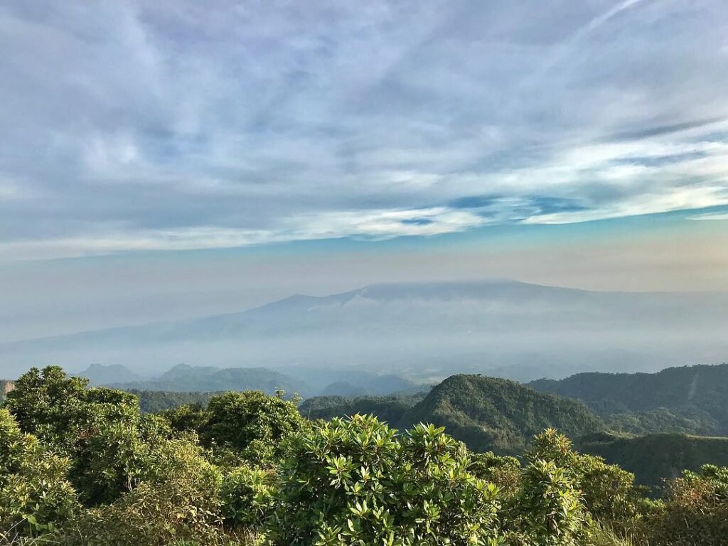
Cawag Hexa, also called Cawag Hexalogy, is known as a brutal six-mountain traverse in Subic, Zambales. With a cumulative elevation gain of 2,100+ MASL, the hike is one of the most challenging climbs in Luzon. Combining six mountains in the Zambales Coastal Range, it is famous for its scenic views of grassy mountain ranges and the West Philippine Sea and is infamous for being one of the most scorching hikes in the entire country.
The six mountains of Cawag Hexa, in route order, are: Mt. Balingkilat (1,100+ MASL), Mt. Bira-Bira / Mt. Nagsasa (570+ MASL), Mt. Naulaw (530+ MASL), Mt. Dayungan (900+ MASL), Mt. Cinco Picos junction (650+ MASL) or Peak 1 (770+ MASL), and Mt. Redondo (610+ MASL).
On Google Maps, search “Sitio Cawag Settlement” or “Cawag Resettlement Area” to locate the jump-off.
If you are exploring other Zambales destinations around the same trip, the Zambales tourist spots travel guide covers the broader region well.
How to Get to the Cawag Hexa Jump-off Point
From Manila, take a Victory Liner bus to Olongapo. The fare ranges from around ₱230–₱480, depending on terminal, schedule, and bus type. From Olongapo, you can take a special tricycle to Cawag for around ₱300–₱400 per trip. For groups, a jeepney charter is more practical and costs around ₱2,000–₱3,000.
From Manila, take any Olongapo-bound bus and alight at Subic, Zambales town proper to meet your guide. The usual meeting place is at the Subic Fire Station, where registration is mandatory. Most joiner groups depart Manila at 7:00 PM–9:00 PM the night before to arrive at Sitio Cawag around 1:00 AM.
The road going to Cawag uses paved national roads until the final rural approach. The last segment is narrow but passable for private vehicles and chartered jeeps. Parking is available near the Chieftain’s Hall or Barangay Hall area and is generally safe because it is managed by the local community.
For a private group, a van or multi-cab charter is the most practical option. This removes the anxiety of missing a bus connection at 2 AM in Olongapo.
Permits, Fees, and Guide Requirements at Cawag Hexa
Registration is handled through the Subic Tourism Office, with onsite logging at the Chieftain’s Hall in Sitio Cawag. Your day begins with a stop at the Subic Municipality Fire and Rescue Team headquarters for the initial registration. After an overnight drive to Zambales Province, you’ll arrive early morning for registration at this headquarters, followed by the Cawag Resettlement Registration Center.
Registration is handled through the Subic Tourism Office. As of May 2026, hikers need 2 copies of the Official Tourism Form and an Official Receipt.
Historically, guide fees have been structured per mountain. Registration fee: ₱60/pax, Guide fee: ₱500/mountain, guide ratio is 1:5. These figures are from organized joiner hikes from prior years; confirm current rates directly at the Chieftain’s Hall before your climb, as fees can be updated.
A local guide is required — not optional. If you are experienced, prepare properly: book a guide, start early, bring enough water, protect your skin, and respect the cutoff. For most hikers, a joiner or private guided hike is better than DIY because the route depends heavily on timing, transport, local rules, and guide coordination.
The local guides at Sitio Cawag are Aeta community members from the resettlement area. The Cawag Aeta community manages the registration system and provides the required local guides. Their knowledge of the route — including trail conditions, water source timing, and weather behavior — is practical and earned from years on that terrain. Hire your guide through the official chieftain’s hall, not from informal fixers outside. Paying the full guide rate directly supports the Aeta guides and their families. Treating them with respect and patience, especially if you are slowing down, goes a long way on a trail this long.
DENR official website — check for any updated national park regulations before your climb.
What Is the Cawag Hexa Trail Like?
Cawag Hexa is one of the toughest hikes in Zambales because the trail is hot, exposed, long, and unforgiving if you bring too little water. The full route usually takes 15–20 hours, crosses six peaks, has almost no shade, and requires strict water, heat, and pacing management.
The trail traverses the rugged Cawag Hexa circuit, showcasing the dry, savannah-like ecosystem typical of the Zambales coast. The terrain shifts from bamboo thickets and river crossings at the base to barren, rocky ridges that reflect intense heat.
Stage Breakdown with Difficulty Scores
Stage 1 — Jump-off to Mt. Balingkilat Summit (1,100+ MASL)
Difficulty: 5/5 — Near-vertical boulder assault with loose rock and sharp grass; hands-on scrambling required above the campsite.
The first part of the hike passes Mt. Balingkilat, which requires technical climbing skills through rock walls and boulders with almost 90-degree vertical climb for a total distance of 7.4 km. After taking a fairly flat trail, you reach the first water source at the base of Mt. Balingkilat after about an hour. Refill completely here — it is your last guaranteed source before Balingkilat’s summit.
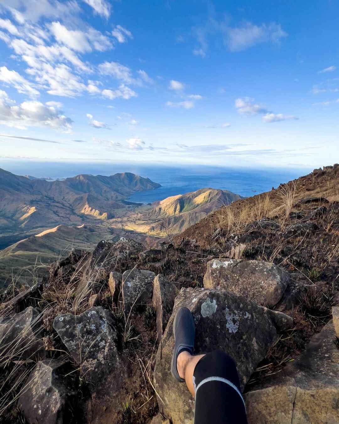
I did this section in April 2026 in total darkness until the sky began to pale around 5 AM. The incline on the upper third of Balingkilat is not a metaphor. You are pressing your palms against rock faces and pulling yourself up while trying not to kick the person below you. The reward at the top is direct: standing on the roof of the Zambales coastal range with the coves laid out below you in the early morning light.
Stage 2 — Balingkilat to Mt. Bira-Bira / Nagsasa (570+ MASL)
Difficulty: 4/5 — Steep, loose-rock descent onto a knife-edge ridge; serious ankle-roll risk, and the sun hits fully by this point.
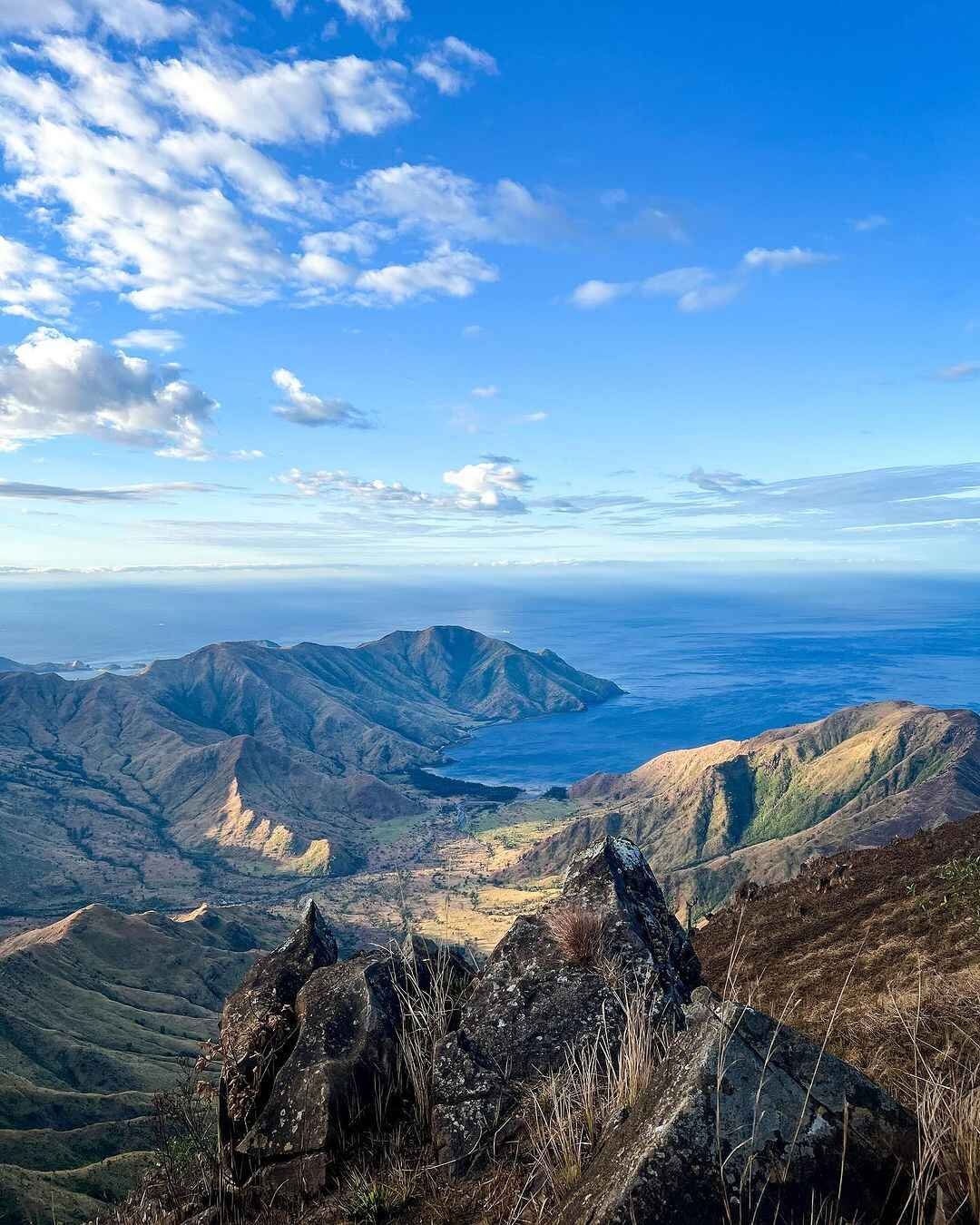
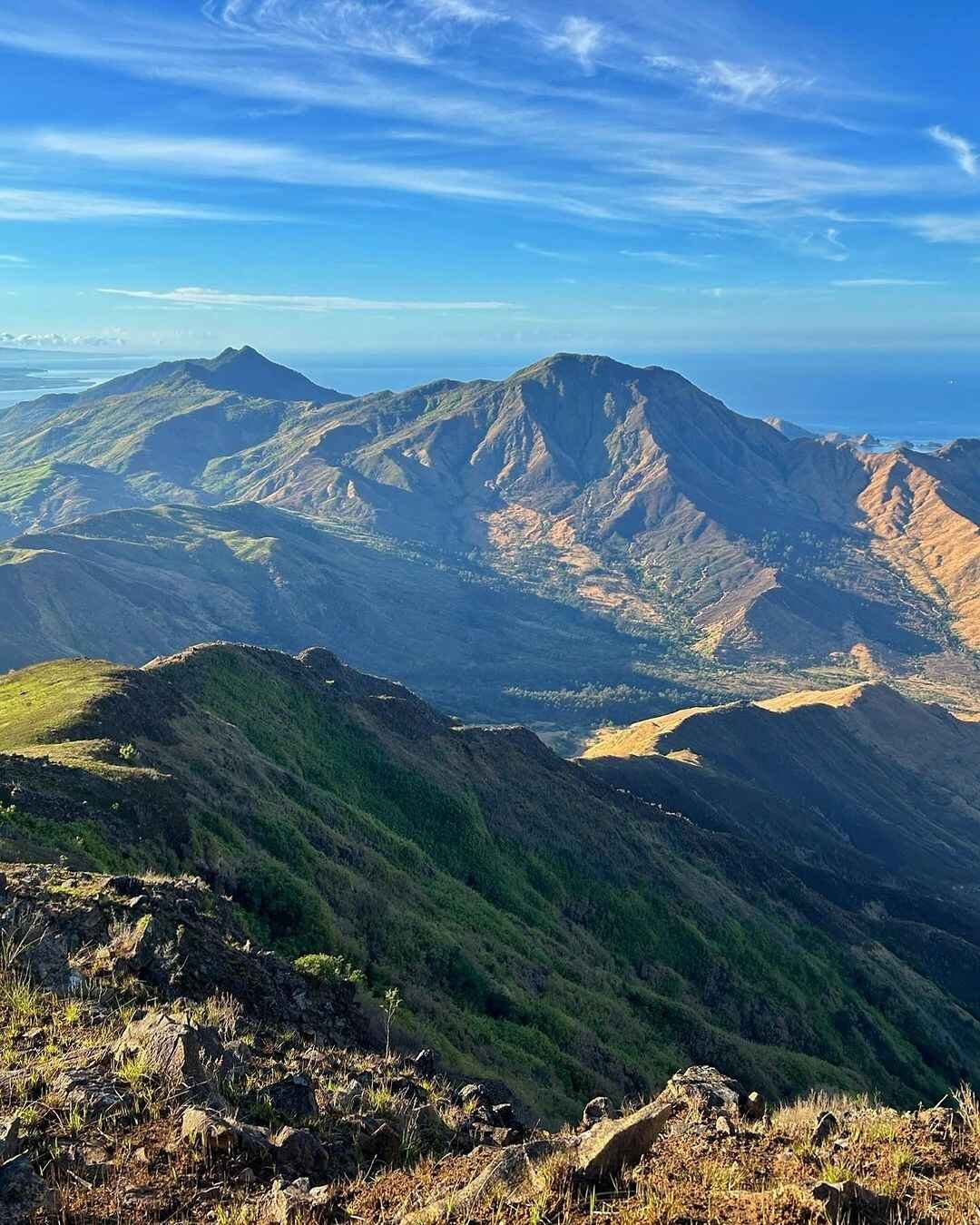
The descent from Balingkilat is intense — knife-edge trails and sharp boulders. From Balingkilat to Bira-Bira, one must descend a total of 1,950 feet that passes steep ridges and rocky knife-edge trails. It then opens into rolling open grassland.
Standing on Balingkilat’s summit, I looked back down at Nagsasa Cove on one side and could see the line of the entire traverse ahead. That view — the ribbon of ridgeline leading to each successive peak — is the moment that burned into my memory from the whole climb.
Stage 3 — Bira-Bira to Mt. Naulaw (530+ MASL)
Difficulty: 2/5 — Relatively gentle connecting ridge, but heat exposure makes even easy terrain exhausting by mid-morning.
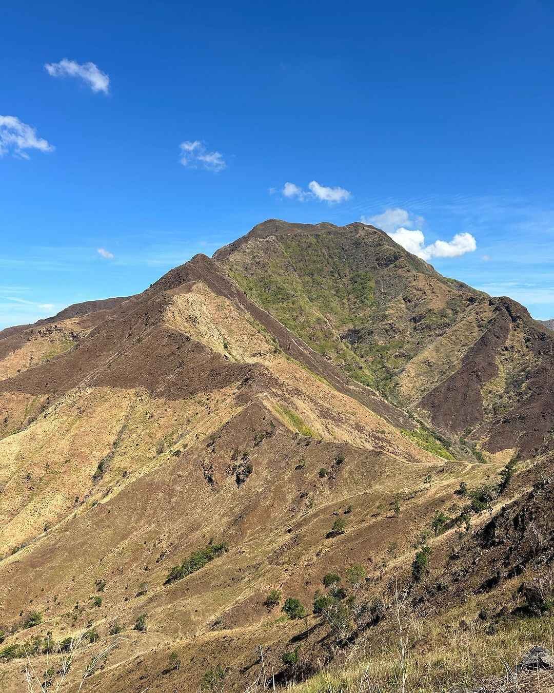
The connecting trail from Bira-Bira to Naulaw was the easiest part of the hike. Despite this easiness, it is still tiring due to the punishing heat of the sun. Naulaw’s summit is marked by a communication tower.
Stage 4 — Naulaw to Mt. Dayungan (900+ MASL) — The Crux
Difficulty: 5/5 — Long steep climb in full midday sun; 4–5 false summits, a critical time cutoff, and the second water source at the base.
Mt. Dayungan is the crux. It has 4–5 false summits, and many hikers reach this section when the heat is already intense. If you are not at the Dayungan water source by around 12:00 PM, you risk missing the common 1:00 PM cutoff.
Ascending Mt. Dayungan during midday is a great ordeal. It also has a false summit — the real summit is still a half-hour ascent beyond what appears to be the top. This is the section that breaks most incomplete attempts.
Stage 5 — Dayungan to Mt. Cinco Picos (650–770+ MASL)
Difficulty: 3/5 — Steep but shorter; the Cinco Picos campsite is reachable before the true summit, which is optional under guide discretion.
Cinco Picos is often done through the junction instead of the true summit, depending on pacing, weather, guide decision, and group strength. Mt. Cinco Picos has some of the best views of all six mountains on the Cawag Hexa climb. From here you can see Silanguin Cove and the full sweep of the western Zambales coast.
Stage 6 — Cinco Picos to Mt. Redondo (610+ MASL) and Descent
Difficulty: 3/5 — Rolling grassland that looks easy but never fully lets up; dense tall grass in the final section can disorient at night.
Mt. Redondo is composed mostly of rolling terrains covered in tall grasses. The gentle slopes keep going up and down — just when you’re about to rest, there comes another gradual assault. Redondo’s trail can be described as “so near, yet so far” — you can see the road and the highway, but it can be deceiving, as the trail seems to be going nowhere through a densely overgrown grassland.
What I’d Do Differently Next Time
Climbing in April was a deliberate choice — clear skies, no rain, good footing. What I underestimated was the heat compounding with dehydration by the time I reached Dayungan. I brought five liters of water but had already consumed four before reaching the Dayungan water source.
Next time I would carry a soft flask setup with one liter reserved strictly for Dayungan’s climb. I would also bring a collapsible trekking umbrella rather than relying on long sleeves alone. Multiple experienced hikers I spoke to after the hike said the umbrella was the single biggest comfort upgrade on the exposed mid-section. I skipped it and paid for it between peaks three and four.
I would also arrive at the jump-off no later than 1:00 AM instead of 1:45 AM. Those extra 45 minutes pushed my Dayungan arrival 30 minutes past the comfortable margin.
Best Time to Climb Cawag Hexa
The best time to hike Cawag Hexa is during cooler dry months, not peak summer. Dry weather gives better views and safer footing, but March to May can be brutally hot.
November through February is the most practical window. Temperatures are lower, the trail footing on rocky sections is more stable, and you avoid the April–May inferno that gives the hike its “gateway to hell” reputation. The views of the coves are also sharpest in the dry months, when haze from humidity is minimal.
June through October brings the rainy season to Zambales. The trail becomes slippery on the boulder sections, talahib becomes harder to navigate, and the descents on Balingkilat and Bira-Bira are genuinely dangerous when wet. Most organized joiner events avoid this window entirely.
Hiking in summer (March–May 2026) carries very high heat risk. The best strategy is to start at 1:00 AM–2:00 AM, reach Balingkilat near sunrise, and aim to reach the Dayungan water source before noon.
If you want to compare difficulty windows, the nearby Mt. Tapulao is another Zambales major hike that rewards cooler-season planning.
Budget Breakdown for Climbing Cawag Hexa
| Expense | Cost (PHP) |
|---|---|
| Bus fare Manila–Olongapo (one way) | ₱230–₱480 |
| Tricycle / jeepney transfer Olongapo–Sitio Cawag | ₱300–₱400 (tricycle), ₱2,000–₱3,000 (jeep charter) |
| Registration fee | ~₱60–₱100/pax |
| Environmental fee | Included in most organized packages |
| Guide fee | ~₱500/mountain (guide ratio 1:5) |
| Trail food and water supplies | ₱300–₱600 |
| Joiner package (all-in, Manila round-trip) | ~₱2,200/pax |
| Budget estimate (DIY, solo) | ₱1,500–₱2,500 |
| Budget estimate (joiner package) | ₱2,200–₱2,800 |
Organized joiner packages like those offered by Tanaw Explorer run at approximately ₱2,200 per person and include round-trip van, toll fees, registration fee, environmental fee, local tour guide, and a climb certificate.
What to Pack for Cawag Hexa
Around 90% of the trail has almost no canopy cover, so shade is extremely limited. The trail passes through open grasslands, rocky ridges, sharp talahib, and hot exposed slopes. This is why long sleeves are not just for sun protection — they also shield your arms from the razor-sharp grass.
| Item | Essential? |
|---|---|
| Water: 4–6 liters minimum | Yes |
| Headlamp + extra batteries | Yes |
| Long-sleeved shirt | Yes |
| Long pants or trail tights | Yes |
| Ankle-support trail shoes / boots | Yes |
| Packed lunch + trail snacks | Yes |
| Sunscreen SPF 50+ | Yes |
| Trekking poles | Strongly recommended |
| Trekking umbrella | Recommended (mid-section heat) |
| First-aid kit + blister patches | Yes |
| Electrolyte tablets / sports drinks | Yes |
| Emergency whistle | Yes |
| Extra garbage bag / waste bag | Yes |
| Gloves (for rock scrambling) | Recommended |
Bring all your food. There are no food stops or carinderias along the way. The only carinderia near the jump-off area is open at the end of the hike — and even then, supply is limited.
Safety Tips for Climbing Cawag Hexa
Cawag Hexa has claimed lives. A hiker died attempting to complete the Cawag Hexa trail. The fall occurred while trying to summit Balingkilat Peak — the most challenging ascent of all six peaks. This is not a scare tactic. It is context that every hiker planning this route needs to carry.
The most common hazards:
The trail is hot, exposed, long, and unforgiving if you bring too little water. The hardest parts are not only the climbs, but the heat, limited shade, false summits, and the pressure to reach Dayungan before the cutoff.
- Heat exhaustion — Hits hardest between peaks 2 and 4, when the sun is highest and water is lowest.
- Falls on Balingkilat — The boulder section near the top requires careful three-point contact at all times. Do not rush.
- Ankle injuries — Hikers will encounter a knife-edge path with precarious footing on crumbling volcanic soil.
- Getting lost near Redondo — Keep your distance close at dusk because one can get lost in the monotonous but winding grassland.
The “Cawag Hexit” is the designated early exit route. The Cawag Hexit is where most take if they couldn’t take the scorching heat of the sun. It is accessible between peaks 2 and 3 and leads toward the coves. Know where it is before you need it.
Post-hike recovery matters. After a 15–20 hour hike with 1,930 meters of accumulated gain, your knees, ankles, and hip flexors absorb enormous strain. Plan for at least one full rest day after the hike before any driving or travel. Use compression socks during the return journey to reduce leg swelling. Refuel with carbohydrates and protein within 30 minutes of finishing — the carinderia at the jump-off serves exactly this purpose. If you experience knee pain that persists beyond 48 hours, consult a doctor. Patellar tendinitis from long descents is the most common post-trail injury reported by Cawag Hexa finishers.
Do not attempt this as a first major hike. Cawag Hexa is not beginner-friendly. If you have never done a major climb, try easier Zambales hikes or Cabangan Hexa first before attempting Cawag Hexa.
For context on the broader range of Zambales climbing options — from beginner to advanced — the mountains in the Philippines travel guide provides a good starting point.


Frequently Asked Questions About Cawag Hexa
1. What is the Cawag Hexa difficulty rating?
Cawag Hexa has a 9/9 difficulty level from some organizers. It is a major hike with steep climbs, exposed ridges, limited shade, long trail hours, and serious hydration demands. Other sources rate it 7/9. Either rating reflects a serious multi-peak endurance hike that requires prior major climb experience, not just fitness.
2. How long is the Cawag Hexa trail, and how many hours does it take?
Cawag Hexa has a total trail length of approximately 33.7 kilometers and a cumulative elevation gain of 1,930 meters. It has a trail class of 1 to 4, which characterizes uneven paths and steep terrain that involves scrambling. Most groups finish in 15–20 hours; experienced fast groups have completed it in 12–13 hours.
3. What are the six mountains of Cawag Hexa and their elevations?
In route order: Mt. Balingkilat (1,100 MASL), Mt. Bira-Bira (570 MASL), Mt. Naulaw (530 MASL), Mt. Dayungan (900 MASL), Mt. Cinco Picos (770 MASL), and Mt. Redondo (610 MASL). Mt. Balingkilat is the highest peak and serves as the trail’s physical and psychological anchor. For more on individual Zambales peaks nearby, see the guides for Mt. Kapigpiglatan and Mt. Mariglem.
4. Are there water sources on the Cawag Hexa trail?
There are two reliable water sources on the route. The first water source is at the base of Mt. Balingkilat, reached after about one hour from the jump-off. The second is at the base of Mt. Dayungan, reachable after Naulaw. Outside of these two points, there is no water. Be ready to carry at least 4–6 liters of water. Treat or filter any water from trail sources — do not drink it untreated.
5. Has there been a serious accident on Cawag Hexa?
Yes. The Cawag Hexa accident record is a documented reality in the hiking community. A hiker died attempting to complete the Cawag Hexa trail, falling while trying to summit Balingkilat Peak — the first and most technically demanding of the six peaks. The boulder section near Balingkilat’s upper slopes requires full attention and should never be rushed. Train specifically for scrambling and vertical sections before attempting this route.
Final Verdict: Should You Climb Cawag Hexa?
4.5 out of 5 for experienced hikers who have completed at least two prior major climbs. Cawag Hexa delivers exactly what it promises — six peaks, total physical commitment, and views of the West Philippine Sea coastline that you will not get from any single-peak hike in Zambales. The moment I crested Balingkilat in the early morning and tracked the ridgeline all the way to Nagsasa Cove was worth every meter of the approach. Come prepared with enough water, the right start time, and a guide you trust — and the Cawag Hexa hike will be the benchmark you measure every future climb against.
For those working up to Cawag Hexa, the Harkor climb guide is another serious Zambales challenge worth adding to your training list.
Subic Bay Metropolitan Authority tourism office page — for updated local ordinances and trail access rules.