Mt. Arayat via Quad Peak is a 12–14 hour technical day hike in Pampanga that takes you across all four peaks — TKO, Pinnacle, South, and North — rated 7/9 in difficulty. It demands prior major climb experience, at least 4–5 liters of water, and a mandatory licensed guide. Do not attempt this as your first or second mountain.
Mt. Arayat via Quad Peak Quick Guide
| Detail | Information |
|---|---|
| Mountain | Mt. Arayat |
| Location | Magalang & Arayat, Pampanga, Central Luzon |
| Province | Pampanga |
| Elevation | 1,030 MASL (North Peak / true summit) |
| Difficulty | 7/9 (Quad Peak route) |
| Jump-off | Brgy. San Juan Baño, Arayat, Pampanga |
| Best Season | December to early March |
| Trek Time | 12–14 hours (full Quad Peak circuit) |
| Registration | DENR Ranger Station, Brgy. San Juan Baño |
| Campsite | North Peak (beside military/police outpost) |
Table of Contents

Where Is Mt. Arayat via Quad Peak Located?
Mt. Arayat is located between the municipalities of Arayat and Magalang in the province of Pampanga, Central Luzon — and its position is impossible to miss. Rising in geological isolation to 1,026 MASL, this extinct stratovolcano does not share its weather with a range; it absorbs the full humidity of the Central Luzon plains.
Mt. Pinatubo is located 26 km west, while Manila is located 75 km to the south. This dormant stratovolcano is easily visible from the North Luzon Expressway (NLEX), especially near the San Fernando exit. Anyone who has driven north out of Metro Manila has seen it — a green pyramid rising abruptly from the flat agricultural sea of Pampanga, looking like it was dropped there by a giant.
Mt. Arayat was officially declared a national park in 1933 and a tourist spot in 1997. Covering approximately 14.5 square miles (37.7 square kilometers), the park is one of the country’s oldest national parks and serves as a vital green refuge in the heart of the Central Luzon plains.
Mt. Arayat has four peaks: North, South, Pinnacle, and TKO Peak — with the North Peak being the true summit. Somewhere between 2016 and 2018, locals managed to blaze trails to the Pinnacle and TKO Peak in an effort to entice hikers to return to the mountain, and thus the Quad Peaks hike was born.
The mountain is also steeped in Kapampangan mythology. Mt. Arayat is best known for the legend of Maria Sinukuan — a diwata (fairy or forest spirit) said to reside within the mountain’s hidden caves and peaks, and in Kapampangan folklore, a protector of the forest and a figure of both generosity and wrath.
You can pair your Mt. Arayat adventure with other Pampanga tourist spots for a full weekend trip from Manila, or browse our complete guide to mountains in the Philippines if you’re planning your next peak after Arayat.
How to Get to the Mt. Arayat via Quad Peak Jump-off Point
The jump-off for the Quad Peak route is the DENR Ranger Station at Barangay San Juan Baño, Arayat, Pampanga — the same side used for the South Peak and Pinnacle trails. Getting here from Manila is a three-leg journey: bus, jeepney, then tricycle.
From Manila (Cubao) by public transport:
- Bus: Ride a bus from Cubao going to San Fernando, Pampanga (₱150-250/way, approximately 2 hours). Victory Liner operates buses to San Fernando, Pampanga from their Cubao, Quezon City terminal, with their earliest trip departing at 5:30 AM.
- Jeepney: Alight at SM City Pampanga, then ride a jeepney going to Arayat town proper (₱30/way, approximately 30 minutes).
- Tricycle: From the Arayat town proper, hire a tricycle to the registration site at Brgy. San Juan Baño. Budget ₱100–₱150 for the short ride.
From Angeles City or Clark: If you’re based in Angeles, a direct tricycle or UV Express to San Fernando Pampanga and then a jeepney to Arayat is your fastest option. Getting transport back from the Magalang side after a traverse is harder; booking a taxi or ride-share beforehand is strongly advised.
By private vehicle: Drive via NLEX and exit at San Fernando or Arayat. A ₱100 parking fee is charged at the Magalang entrance area. Parking at the San Juan Baño side is available near the ranger station compound.
For the Quad Peak route, most organized groups depart Manila by midnight, assembling at around 12:00 AM, leaving for Arayat by 1:00 AM, arriving at the ranger station by 3:00 AM, and starting the trek by 4:00 AM to hit TKO Peak around sunrise. This timing is deliberate — you want to conquer the hardest technical sections before Pampanga’s brutal heat sets in.

Permits, Fees, and Guide Requirements at Mt. Arayat via Quad Peak
As of 2026, a medical certificate is not strictly mandatory for Mt. Arayat. However, all hikers must sign a Liability Waiver and Health Declaration Form at the jump-off point. Walk-ins are accepted, but for the Quad Peak route, coordinating in advance with a local guide or organized hiking group is a practical necessity.
Fees at a glance:
Registration fees are decentralized; prepare to pay separate environmental fees in Magalang (₱50–₱100) and entrance fees at the Arayat National Park resort (₱75–₱100).
As of 2026, the standard guide fee for the Mt. Arayat Traverse is ₱1,800–₱2,500 for a group of 5 hikers. For the more technical Quad Peak route, expect to pay around ₱3,500.
Guide service is mandatory. You must hire a local guide before stepping on the dirt — this rule keeps you safe and directly helps the local community. For the Quad Peak route specifically, this isn’t just a bureaucratic requirement: the trail to TKO and Pinnacle Peaks involves unmarked approach lines, loose volcanic rock, and sections where even experienced hikers have lost the trail in low visibility.
Near the 7th Station of the Cross is where the DENR Registration Area is located. This is your first stop before heading uphill. Bring small bills — the fees at each checkpoint are collected separately and station staff rarely have change for large denominations.
What Is the Mt. Arayat via Quad Peak Trail Like?
The Quad Peak route includes the Pinnacle and TKO Peaks, extending the hike to 14 hours and requiring highly technical maneuvering around sharp volcanic rocks. This is strictly for advanced hikers.
The Agricultural Apron (Trailhead to Forest Edge)
The hike begins deceptively easy. The terrain shifts rapidly from the loamy “Agricultural Apron” full of tomato and okra crops at the base, to a dense Dipterocarp forest, and finally to technical rock scrambling at Haring Bato. The trail starts with flats and moderate slopes on soft earth and rocks, and you spend about 20–25 minutes walking under the open sky before reaching the first resting hut.
This opening stretch is where the mountain begins its psychological game. The sun hasn’t fully risen, the air is still cool, and you feel strong. Enjoy it — it won’t last.
TKO Peak via the TKO Trail
Departing from the ranger station at 4:00 AM, the itinerary targets TKO Peak at approximately 6:00 AM — timed for sunrise and breakfast before the real assault begins.
The Mt. Arayat Quad Peak route takes 12–14 hours on a forested trail, and the hardest part is the solid assault trail on rugged cliffs at approximately 75–85 degrees with no flat sections in between. TKO is the technical opener of the circuit — a near-vertical slab of volcanic rock that requires both hands and trust in your footwear. This is not a trail where trail runners will save you; you need aggressive, stiff-soled hiking boots.
Pinnacle Peak via the Hunter’s Trail
After TKO, the route transitions to the Hunter’s Trail toward Pinnacle. There are sections where minor scrambling and use of ropes are required. This route stretches about 8 kilometers between the Pinnacle and the South Peak.
The standard itinerary estimates arriving at Pinnacle Peak at around 10:30 AM, before resuming toward South Peak. By this point, the Pampanga heat is fully operational. The forest canopy provides some relief, but the climbing effort combined with the humidity creates a very efficient furnace. Hydration becomes a survival issue, not a comfort issue.
South Peak and the Monkey Segment
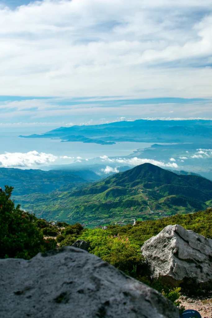
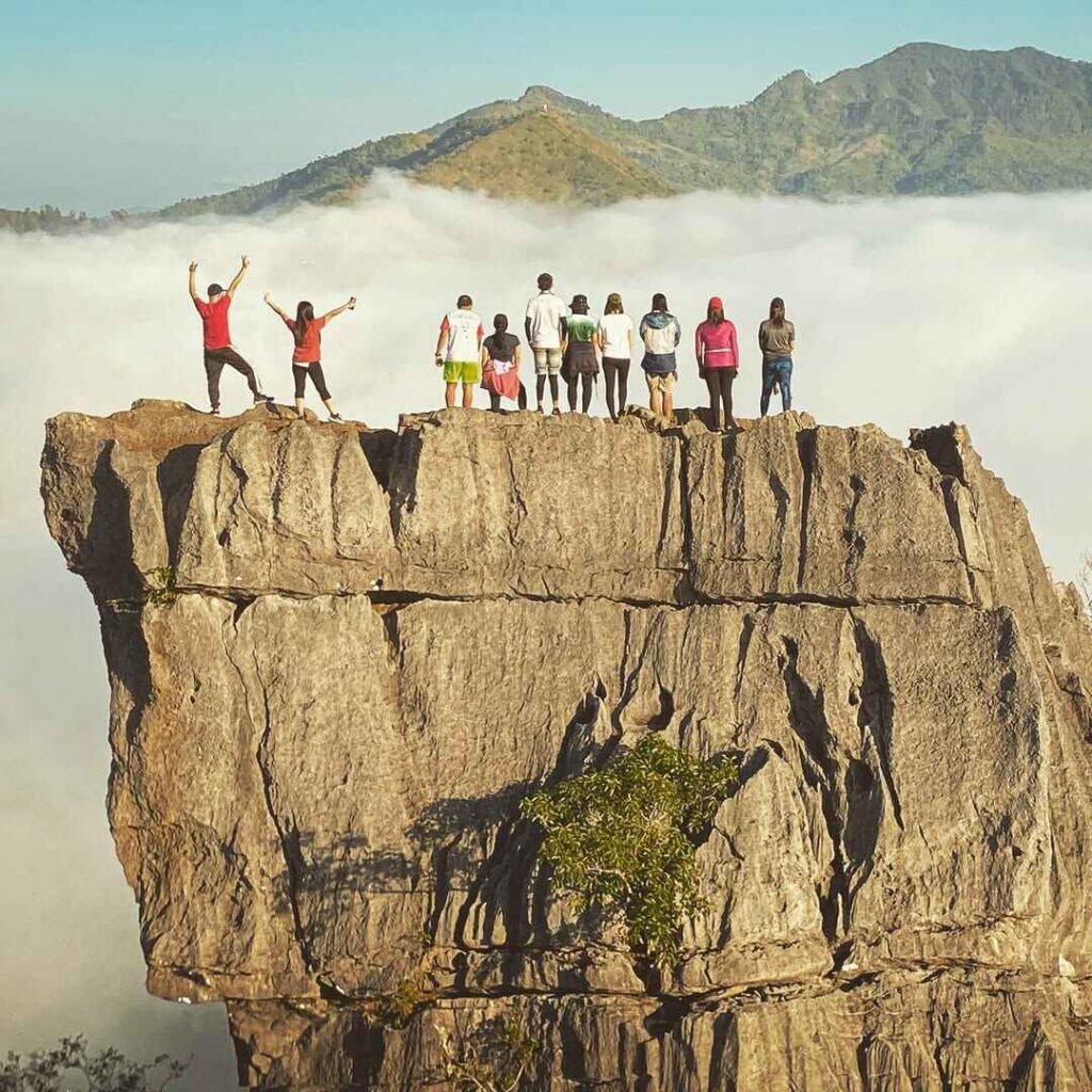
South Peak arrives at approximately 11:30 AM and offers the first major viewdeck payoff of the day. The landmark here is the panoramic view — at 270 degrees, it encompasses the Central provinces of Pampanga, Nueva Ecija, Zambales, and Bataan. From here, a beautiful sunrise view over the vast plains of Mt. Arayat reveals the Pampanga River snaking through the fields.
After lunch at the South Peak viewdeck, the circuit continues via the Monkey Trail — the section I found most memorable on my June 2026 climb. Connecting the two summits is the notorious “saddle,” a jagged ridgeline often called the Monkey Trail. The name is earned. You are not walking here — you are moving on all fours, palms on sun-warmed volcanic rock, feet finding ledges that feel temporary. Every scramble move demands deliberate thought.
The terrain shifts rapidly on this ridgeline, and Haring Bato (King’s Rock) marks the crux of the technical section — a towering boulder that requires you to commit to a stem-and-pull sequence that looks more intimidating than it is, provided you keep your centre of gravity low and your guide’s advice in your ears.
North Peak (True Summit)
At the North Peak, which serves as the campsite of an overnight traverse, the view is 270 degrees and encompasses the Central provinces of Pampanga, Nueva Ecija, Zambales, and Bataan. The landmark here is the police outpost/tower.
The standard Quad Peak itinerary reaches the North Peak at approximately 1:30 PM, begins descent at 2:00 PM, and arrives back at the ranger station by 4:30 PM. In practice, slower groups should add 1–2 hours to this timeline, especially on the descent where the red clay becomes treacherous.
The Descent: Red Soil and the Knee Test
The descent from the South Peak to Brgy. San Juan Baño is famous for its reddish clay soil. Even if it hasn’t rained in days, the morning dew can turn this into a grease-like slide. Trekking poles are not optional equipment on this section — they are load-bearing infrastructure for your knees after a 12-hour circuit.

Multiple Trails at Mt. Arayat via Quad Peak: Which One?
The Quad Peak route is the most comprehensive — and demanding — circuit on Mt. Arayat, but it isn’t the only option. Here’s how the routes compare so you can make an informed decision:
There are two other trails for extra challenge: the Mt. Arayat Pinnacle trail (Pinnacle to South Peak, 8 km), or the Mt. Arayat Quad Peak trail which takes about 12–14 hours and includes steep rugged cliffs.
- Magalang Trail (North Peak only): The standard beginner-to-intermediate entry. The path starts flat and easy, passing through quiet farmlands before stepping into thick, cool forest with a steady but friendly climb leading straight to the North Peak. Best for first-timers or those who want to test the mountain before committing to a traverse.
- Standard Traverse (North to South, or South to North): Difficulty rating of 5/9, the classic route most guided groups recommend for a first Arayat visit.
- Pinnacle Peak Trail: A technical step up, rated 7/9, ideal for intermediate-to-advanced hikers who want rope-assisted scrambling without the full day commitment of the Quad route.
- Quad Peak Circuit: All four peaks, 7/9, 12–14 hours. Covers the full geological and technical character of the mountain. For experienced hikers only.
For context on how these difficulty ratings compare across Philippine mountains, see our guide to beginner-friendly minor climbs and our Major Climb difficulty guide (5/9–8/9).
Rock Scrambles and Technical Sections
The Mt. Arayat Quad Peak route earns its 7/9 difficulty rating primarily through three technical choke points.
TKO Peak assault: The hardest part of the Quad Peak is the solid assault trail on rugged cliffs at approximately 75–85 degrees with no flat sections in between. You will use fixed ropes on the steepest pitches. Gloves are not optional — the volcanic rock has sharp edges that will shred bare palms on a prolonged grip.
The Monkey Trail / Haring Bato: Vertical clay and rock walls with rope segments abound, making this technically a major climb. The key hazard here is not the height — it’s the loose volcanic gravel that sits on top of otherwise solid rock faces. Your guide will demonstrate secure step placements. Follow exactly.
Red Soil Descent: Even if it hasn’t rained in days, the morning dew can turn the red clay soil into a grease-like slide. Descending this section in June — as I experienced — with residual morning moisture still on the clay is genuinely hazardous without poles or a controlled descent technique.
No technical climbing gear (cams, nuts, harness) is required for the Quad Peak circuit. The fixed ropes provided along the route are adequate for scrambling assistance, not lead climbing. However, leather or synthetic climbing gloves, ankle-high hiking boots with aggressive lug soles, and trekking poles should be considered mandatory.

Best Time to Climb Mt. Arayat via Quad Peak
The best time to hike Mt. Arayat is between December and early March, when temperatures are cooler and the skies are clearer.
The best specific month is February, when the skies are clearest with the least rain, the muggy period has not yet begun, and the temperature is cooler than the rest of the year. The cool season runs from the end of November to the beginning of February — January being the coolest month with an average low of 22°C (72°F) and high of 30°C (86°F).
From mid-May to late October, there is the highest chance of rain on any given day, with August being the wettest month. The drier season lasts from late October to mid-May — the driest month being January with an average of 2.9 wet days.
My June 2026 climb confirmed what the data says: the wet season turns the red soil descent into a near-impossible slide and makes the TKO assault dangerously slippery. It is doable, but the risk-to-reward ratio shifts unfavorably. If you are planning your first Quad Peak, choose February for the best combination of dry trail conditions, clear summit views, and manageable heat.
Budget Breakdown for Climbing Mt. Arayat via Quad Peak
Many hikers underestimate the cost of Mt. Arayat because it is a day hike. However, the multi-modal transport (Bus + Jeep + Trike) adds up quickly.
| Expense | Cost (PHP) |
|---|---|
| Bus fare (Cubao to San Fernando, one way) | ₱150-250 |
| Jeepney (San Fernando to Arayat town) | ₱30-60 |
| Tricycle to Brgy. San Juan Baño | ₱50–₱150 |
| Environmental/Registration Fee (Arayat side) | ₱75–₱100 |
| Environmental/Registration Fee (Magalang side, if traverse) | ₱50–₱100 |
| Guide Fee (Quad Peak, shared among 5 hikers) | ~₱700/pax (₱3,500 total) |
| Food and water (trail snacks + packed meals) | ₱300–₱500 |
| Return transport (tricycle + jeepney + bus) | ₱200–₱250 |
| Estimated Total (DIY, shared group) | ₱1,800–₱2300/pax |
Prices above assume a group of five sharing the guide fee. Solo joiners on organized group hikes (e.g., through Tanaw Explorer or similar operators) can expect an all-in event fee of approximately ₱2,000/pax, which is excellent value given the complexity of the route.

What to Pack for Mt. Arayat via Quad Peak
The no-water-source reality of this mountain defines your packing list more than any other single factor. There is no water source on the trail — bring at least 4–5 liters.
| Item | Essential? |
|---|---|
| Hiking boots (ankle-high, lugged sole) | Yes |
| 4–5 liters of water | Yes (non-negotiable) |
| Trekking poles | Yes |
| Climbing/work gloves | Yes |
| Headlamp with extra batteries | Yes (pre-dawn start) |
| Poncho / rain cover | Yes |
| Packed lunch + trail snacks (nuts, gels, banana) | Yes |
| Arm sleeves (sun + scratch protection) | Yes |
| Insect repellent (DEET-based) | Yes |
| Emergency first aid kit | Yes |
| Extra clothes in a dry bag | Yes |
| Trekking poles | Strongly Recommended |
| Power bank | Recommended |
| Gaiters | Recommended (wet season) |
| Trekking umbrella | Optional |
Mosquitoes, flies, and other insects are abundant on Mt. Arayat, so insect repellent is a must. The lower forested sections are the worst for insects; once you clear the tree line, the wind keeps them manageable.
Safety Tips for Climbing Mt. Arayat via Quad Peak
Start before dawn. More hikers tap out due to dehydration than fatigue on this mountain. An early start means you complete the most technical sections before peak heat (10 AM–2 PM).
Water is your primary risk variable. There is no water source on Mt. Arayat. For day hikes, 2 liters should suffice for a regular person; for the Quad Peak, plan for 4–5 liters minimum.
Never skip the guide for Quad Peak. The TKO and Hunter’s Trail approach lines are unmarked and easy to lose in pre-dawn darkness or afternoon haze. A disoriented group on the Pinnacle ridge with no phone signal and fading daylight is a genuine emergency scenario.
Know when to turn back. The decision point is the Pinnacle — if your group’s weakest member is already significantly dehydrated or showing signs of heat exhaustion after Pinnacle, abort to South Peak and descend via the standard trail. The mountain will still be there.
Inform someone of your itinerary. Leave a detailed itinerary with a non-climbing contact, including expected return time and the ranger station contact information at Brgy. San Juan Baño. Rescue access to the Pinnacle and TKO area is slow and complex.
Footwear is not negotiable. The trail uses ropes tied to trees on technical sections — hiking boots are critical, not optional.
If you’re building toward Quad Peak, first complete the standard Mt. Arayat Traverse and a similar-difficulty mountain. For reference on what a comparable challenge looks like, our Mt. Pinatubo hike guide covers another iconic Central Luzon summit that can serve as preparation.

Frequently Asked Questions About Mt. Arayat via Quad Peak
1. Is Mt. Arayat via Quad Peak suitable for beginners?
No. The Quad Peak route carries a difficulty rating of 7/9 and requires technical scrambling on near-vertical volcanic rock at gradients of 75–85 degrees. Beginners should first complete the standard North Peak (Magalang) trail and the full traverse before attempting Quad Peak. Ideally, you should have at least two prior major climbs under your belt before joining a Quad Peak group.
2. How long does the Mt. Arayat Quad Peak hike take?
It takes 12 to 14 grueling hours to finish the full Quad Peak circuit. The standard organized group itinerary departs the ranger station at 4:00 AM and returns by 4:30 PM at the earliest. Slower groups or those who linger at viewpoints should plan for a 5:00–6:00 PM return.
3. Are there water sources on the Quad Peak trail?
No. There is no water source along the trail, which makes it one of the most logistically demanding aspects of the climb. Carry a minimum of 4–5 liters per person, more if you run hot or are climbing during summer or wet season months.
4. What permits do I need for Mt. Arayat Quad Peak?
All hikers must sign a Liability Waiver and Health Declaration Form at the jump-off. Walk-ins are generally allowed, but large groups should coordinate with the Magalang Tourism Office or Arayat National Park in advance. Registration fees are collected separately at both the Magalang and Arayat sides — prepare ₱50–₱100 in small bills at each checkpoint.
5. What is the Mt. Arayat Quad Peak total cost per person?
For a DIY climber joining a group of five to share the guide fee, the total out-of-pocket cost runs approximately ₱1,500–₱2,000 per person, inclusive of transport, registration fees, guide share, and food. Joining an organized hiking tour typically costs around ₱2,000/pax all-in, which includes transport coordination and an experienced guide familiar with all four peak approach lines.
Final Verdict: Should You Climb Mt. Arayat via Quad Peak?
4.5 out of 5 for advanced and technical hikers. Mt. Arayat via Quad Peak is one of the most complete one-day technical hikes accessible from Manila — four peaks, genuine rock scrambling, a mythological backdrop, and a post-hike plate of Pampanga sisig waiting at the bottom. Unlike minor hikes near Manila, this requires significant endurance due to the intense “thermal trap” heat of the Central Luzon plains, and that honest challenge is exactly what makes earning all four summits feel worth every calorie burned. If you’ve done the traverse and want to know what’s left on this mountain, the answer is Quad Peak — and it does not disappoint.
For more hiking adventures across the Philippines, explore our comprehensive guide to mountains in the Philippines and plan your next summit.