

My Honest First-Hand Guide to Climbing Mt. Batulao (2026)
Mt. Batulao is one of the best beginner hikes near Manila — a 811 MASL peak in Nasugbu, Batangas reachable by bus and tricycle from the city in under three hours. The full round trip takes 4 to 6 hours, the views from the sawtooth ridge are genuinely rewarding, and the total budget sits around ₱1,200 per person. If this is your first or second mountain, this is the right one to start with.
Mt. Batulao Quick Guide
| Detail | Info |
|---|---|
| Mountain | Mt. Batulao |
| Location | Brgy. Patutong Malaki, Nasugbu, Batangas |
| Province | Batangas |
| Elevation | 811 MASL (2,661 ft) |
| Difficulty | 4/9 (Pinoy Mountaineer Scale) |
| Jump-off | KC Hillcrest (formerly Evercrest Golf Course) |
| Best Season | November to May (dry season) |
| Trek Time | 4 to 6 hours round trip |
| Registration | Mandatory at jump-off; guide required as of 2026 |
| Campsite | Camp 8 / Peak 8 (New Trail side) |
Table of Contents
Where Is Mt. Batulao Located?
Mt. Batulao is located in Nasugbu, Batangas, standing at 811 MASL. More specifically, the entry point is at the KC Hillcrest Golf Course and Resort in Barangay Patutong Malaki, Nasugbu, Batangas.
Mt. Batulao is an inactive stratovolcano located in northwest Batangas province near the border with Cavite. Geographically, it lies along the northwestern rim of the Taal Caldera and forms part of the Tagaytay Range. That geographic position is exactly why the summit views are so striking — you are essentially standing at the edge of multiple provinces at once.
Mt. Batulao is around 80 kilometers from Manila, and the drive takes approximately 2 hours and 30 minutes via the Cavite-Tagaytay-Batangas Expressway and the Nasugbu Highway. If you have ever looked west from Tagaytay and noticed a jagged, rolling horizon, you have likely seen the silhouette of Mt. Batulao. Unlike the symmetrical cone of Mayon, Batulao is defined by its dramatic “Sawtooth” morphology — a series of 12 peaks formed by millions of years of erosion on this dormant stratovolcano.
I climbed Mt. Batulao in May 2026 and I can tell you: knowing exactly where it sits geographically before you go makes the summit moment far more meaningful. From the top, you can mentally trace the full arc of what you are looking at.
How to Get to the Mt. Batulao Jump-off Point
Getting to the Mt. Batulao jump-off from Metro Manila is straightforward by public bus plus a short tricycle ride.
By Public Transport (recommended):
The most direct way to reach Mt. Batulao is to take a DLTB Co. or BSC bus bound for “Nasugbu” or “Balayan” from the DLTB Buendia Terminal or PITX. The one-way fare ranges from ₱250 to ₱350 depending on the carrier.
You must alight at KC Hillcrest (formerly Evercrest Golf Course), NOT the town proper, then take a ₱150 tricycle to the jump-off point. This is the single most important logistical detail on this entire guide — do not miss it.
Explicitly tell the conductor you are getting off at “Evercrest” or “KC Hillcrest.” Do not just say “Batulao” or “Nasugbu,” as some conductors might mistakenly take you all the way to the Nasugbu Town Proper, which is several kilometers away from the trailhead.
The travel time is usually 2.5 to 3 hours, but leaving by 3:00 AM is strongly recommended to avoid heavy morning traffic on Aguinaldo Highway. I left at around 3:30 AM from Manila and arrived at the jump-off just before 6:00 AM — which is the sweet spot. Before starting, I had a bowl of Batangas lomi at one of the small eateries right at the highway entrance. It is thick, salty, and exactly what you want before a sweaty climb.
By Private Vehicle:
Take the South Luzon Expressway (SLEX) and exit at Santa Rosa or Eton City. Follow the road up to Tagaytay City, then turn right onto the Tagaytay-Nasugbu Highway. Drive past the Tagaytay ridge restaurants and the Batangas border arch. Most hikers park at the KC Hillcrest (Evercrest) entrance or the designated lot near the Tricycle Terminal. The parking rate is ₱50 for motorcycles and ₱100 for four-wheeled vehicles for day hikes.
Permits, Fees, and Guide Requirements at Mt. Batulao
As of 2026, hiring a local guide is strictly mandatory for all hikers upon registration. This is a change that catches some veteran hikers off guard, especially those who climbed Batulao years ago without one.
One thing I want to be completely honest about: the multiple collection points along the trail are real, and they catch first-timers off guard. You will encounter several stops where small fees are collected by different groups — barangay officials, local caretakers, and community members along the route. Mt. Batulao is divided among different barangays, so if one barangay collects, the others do the same. The total adds up across checkpoints, and not everyone collecting has an obvious official receipt. Bring extra small bills.
Here is the general fee breakdown based on current information:
- Registration / Eco Fee at jump-off: collected per person upon registration
- Trail fees at multiple checkpoints: ₱30 per person at the trail junction kiosk where you can also sign the registration book and buy cold drinks
- On the way back, an additional ₱30 per person is collected at another small house along the route.
- Guide fee: Local guides are available on-site; the cost is approximately ₱800 for a group of up to 5 people.
- Parking: ₱100 for a four-wheeled vehicle at the KC Hillcrest lot.
Guides are readily available at the registration area — you do not need to book in advance. Walk up to the jump-off and someone will approach you before you even finish signing in.
What Is the Mt. Batulao Trail Like?
The real challenge on the Mt. Batulao trail isn’t the altitude — it’s the exposure. The trail is 90% open grassland, meaning you are directly exposed to the sun, and the heat index often spikes higher than the actual air temperature. I climbed in May 2026 on a clear, sunny day, and by 9:00 AM the open ridge felt like standing inside a slow oven. Bring more water than you think you need.
Terrain Overview
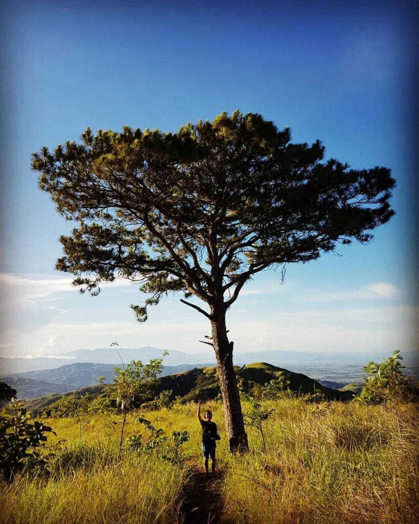
The trail rolls over a chain of sharp, grass-covered peaks, with loose dirt, short scrambles, and sun exposure that will cook you if you start late. Each of the 12 numbered peaks is marked, so you always know exactly where you are — a small but genuinely reassuring feature for beginners.
The hike involves trekking through open grasslands, ascending gentle slopes, and navigating rocky trails. While the hike is suitable for most hikers with a moderate level of fitness, some sections may be steep and require careful footing.
Stage Breakdown (Old Trail to New Trail Loop)
- Jump-off to trail fork: Walk from the KC Hillcrest entrance through a small residential community, about 30–40 minutes at a relaxed pace. Locals along the route are friendly, and this early flat section is a good warmup.
- Trail fork / junction: This is where you choose your trail and where there is a small kiosk where you pay a fee of ₱30 per person and sign a registration book. You can also grab a cold drink here before the climbing starts in earnest.
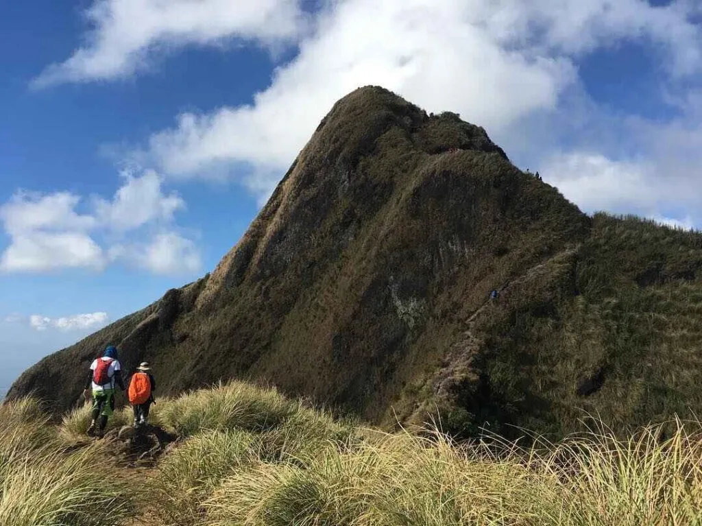
- Camp 1 to Camp 8 (Old Trail): The Old Trail cuts through the eastern flank and quickly transitions from a woodland walk to exposed, rocky ridges past Camp 1. The defining feature here is the “Knife Edge,” a narrow ridgeline with steep drops on both sides. This is where the rope segment appears — and this was honestly my favorite moment of the entire climb. Using the rope on the Old Trail with the ridge dropping away on both sides and the Batangas lowlands visible in the distance is the kind of thing you do not forget.
- Camp 8 / Peak 8 to summit: Camp 8 on the New Trail side is spacious, flat, and protected from the fierce ridge winds if you pitch behind the slope — ideal for overnight hikers. From here, the final push to the 811 MASL summit is short but rewarding.
- Summit to jump-off (New Trail descent): The New Trail is longer, less steep, and easier to descend. Going down via the New Trail after summiting via the Old Trail is the most popular loop, and for good reason — the descent is far more forgiving on tired legs.
What You Can See from the Summit
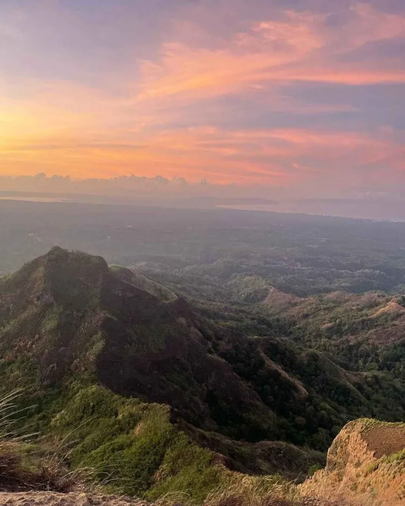
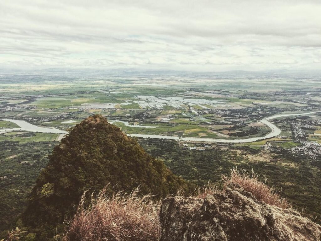
At the summit of Mt. Batulao, you can clearly see the plains of Cavite and Batangas province, the coastline of Nasugbu municipality, the Calatagan Peninsula, Balayan Bay, Tagaytay Highlands, Mt. Talamitam, and some mountains in Cavite province. On a clear May morning, the view from the ridge stopped me mid-sentence. I had been talking to my guide and simply ran out of words.

Is Mt. Batulao Good for Beginners?
Yes — Mt. Batulao is one of the best first mountains in the Philippines, and the experience on the ground confirms what the difficulty rating suggests.
Nicknamed the “Beginner’s Playground,” Mount Batulao offers a challenging yet achievable climb with stunning views. The numbered peaks give beginners visible progress markers the entire way up. You always know which peak you are on, which means you never feel lost or discouraged. If you are comfortable walking for several hours under the sun with short steep sections, this mountain suits you. For a broader list of good starter mountains, check out our guide to beginner-friendly hikes in the Philippines.
The one honest caveat: the heat is real. The heat on Batulao is punishing. If you start your trek at 9:00 AM, you will be climbing the vertical assaults during the hottest part of the day. A beginner who starts at 5:30 AM will have a very different experience from one who starts at 9:00 AM.
Multiple Trails at Mt. Batulao: Which One?
Mt. Batulao features two primary routes — the technical Old Trail and the rolling New Trail. For first-timers, the choice matters.
The New Trail is longer, less steep, and easier to hike. The Old Trail is shorter, steeper, and includes some scrambling sections with ropes. My personal recommendation is this: if it is your absolute first climb ever, do the New Trail up and back. If you have done one or two hikes before and want something more exciting, do the Old Trail up, New Trail down — which is exactly what I did in May 2026 and what made the climb memorable.
The Old Trail features the adrenaline-pumping “Knife Edge” and rope segments, while the New Trail offers open “rolling hills” perfect for a sunset descent. If you have a fear of heights, stick to the New Trail back-and-forth.
The rope segment on the Old Trail sounds intimidating but is manageable for anyone with reasonable upper body strength. The ropes are fixed and the footing is clear — you just need to commit and move deliberately. It was my single most memorable moment on the entire climb, standing at the top of that rope pitch with the whole of Batangas spread out below me. For other challenging options in the area, take a look at our Mt. Talamitam guide and Mt. Lantik guide for comparison.

Best Time to Climb Mt. Batulao
The dry season from November to April offers the most pleasant conditions. You can visit Mt. Batulao any time during the dry season from mid-October to mid-June.
I climbed in May 2026, which is the tail end of the dry season. The sky was completely clear and the views were outstanding, but the heat was relentless by mid-morning. November through February is the sweet spot — cooler air, lower humidity, and sharper visibility. Since the terrain is exposed, the heat can be oppressive during summer and the rains can violently pound on you during the typhoon months. Avoid June through September unless you have a specific reason to go. The wet cogon grass becomes treacherous, and the exposed ridges offer no shelter from rain.
If you hike during the December solstice, you might catch the rare phenomenon where the sun rises precisely between the two highest peaks, bathing the andesite rocks in a brilliant amber glow while the lowlands remain in shadow. That alone is reason enough to plan a December climb.
Budget Breakdown for Climbing Mt. Batulao
A complete budget breakdown for Mt. Batulao comes to approximately ₱1,400 per person for a DIY day hike from Manila. Here is a realistic itemized breakdown:
| Expense | Estimated Cost (PHP) |
|---|---|
| Bus fare (Manila to KC Hillcrest, one-way) | ₱250 – ₱350 |
| Bus fare (return) | ₱250 – ₱350 |
| Tricycle from highway to jump-off (one-way) | ₱150-200 per ride (3–4 pax) |
| Registration / eco fee at jump-off | ₱140 (eco + barangay fee) |
| Trail checkpoint fees (multiple stops) | ₱60 – ₱100+ |
| Guide fee (split among group of 5) | ₱160 – ₱200 per person |
| Food and water on trail | ₱150 – ₱300 |
| Wash-up after hike | ₱20 per pail |
| Parking (if driving) | ₱100 per vehicle |
| Total Estimate | ₱1,400 – ₱1,800 |
Bring extra cash in small denominations for the multiple tollgate-style stops along the trail. The individual amounts are small, but having to break a ₱500 bill at every checkpoint gets old fast.
What to Pack for Mt. Batulao
| Item | Essential? |
|---|---|
| Trail shoes / hiking boots (deep-lug soles) | Yes |
| At least 2 liters of water | Yes |
| Sunscreen (SPF 50+) | Yes |
| Cap or wide-brim hat | Yes |
| Light long-sleeve shirt | Yes |
| Gloves (for rope sections on Old Trail) | Yes if doing Old Trail |
| Trekking poles | Optional |
| Snacks / trail food | Yes |
| Rain jacket or poncho | Recommended |
| First aid kit | Yes |
| Cash in small bills | Yes |
| Headlamp (for early starts) | Recommended |
| Insect repellent | Yes |
Leave your standard running shoes at home. The soil on Batulao is “Batangas Clay” — when dry, it’s loose dust; when wet, it becomes slick mud. Deep-lug trail shoes or hiking boots are necessary to shed the mud.
Gloves are non-negotiable for the Old Trail. The rope segments are rough, and the volcanic andesite rocks are sharp enough to slice your palms if you slip. I wore simple gardening gloves and they were more than adequate. Also, there are no restaurants or stores on Mt. Batulao itself, so it’s best to pack enough food and water for your entire hike. The buko juice huts along the trails are lifesavers if you run short, but do not count on them being open or stocked.
Safety Tips for Climbing Mt. Batulao
The Mt. Batulao trail is beginner-friendly, but “beginner-friendly” does not mean risk-free. Here are the practical safety points that matter most:
- Start before sunrise. You want to tackle the technical rope segments while you are fresh and the sun isn’t scorching yet. If you arrive at KC Hillcrest later than 7:00 AM on a weekend, expect bottlenecks at the rope sections.
- Hydrate aggressively. The real challenge on Batulao is the exposure. The trail is 90% open grassland, and the heat index often spikes higher than the actual air temperature. Drink before you feel thirsty.
- Wear proper footwear. Flip-flops and rubber shoes without grip are a serious hazard on the rocky, dusty descent sections.
- Take the rope segments one person at a time. Traffic jams at the rope sections are common on weekends. Wait for the person ahead to clear before you grab the rope.
- Let your guide lead on unfamiliar sections. Even if you feel confident, the guide knows which footing is reliable and which looks solid but isn’t.
- Register fully and honestly. Barangay registration is not optional — it is the record that local rescuers use if something goes wrong.
- Check the forecast before heading out. The trail can be slippery during or after rain.
For another nearby technical option to compare difficulty levels, our Mt. Apayang guide gives a good sense of what stepping up in difficulty looks like from Batulao.
Frequently Asked Questions About Mt. Batulao
1. What is the Mt. Batulao elevation and difficulty rating?
Mt. Batulao is rated 4/9 difficulty on the Pinoy Mountaineer scale and stands at 811 MASL. It is classified as a minor climb suitable for beginners with average fitness.
2. Is a guide mandatory at Mt. Batulao in 2026?
As of 2026, hiring a local guide is strictly mandatory for all hikers upon registration. Guides are available on-site at the jump-off — you do not need to arrange one in advance. Simply ask at the registration area.
3. How long does the Mt. Batulao hike take for a beginner?
A complete traverse typically requires 4 to 6 hours depending on pace, rest stops, and which trail combination you choose. Beginners on the New Trail back-and-forth should budget closer to 5 hours total, including summit time.
4. Are there food and water vendors on the Mt. Batulao trail?
Locals have made it their business to cater to hikers. Every few hundred metres along the trail, you will find makeshift huts offering refreshments like buko juice, halo-halo, bottled water, and cold drinks. That said, never leave the jump-off without at least 1.5 to 2 liters of your own water — vendors may not be at every stop.
5. What is the best trail for first-time hikers at Mt. Batulao — old or new?
The New Trail offers a more accessible and scenic route to the summit, making it a great option for first-timers and those seeking a less challenging climb. If you are ready for a bit more challenge, ascend via the Old Trail for the rope segment experience and descend via the New Trail. If you have any fear of heights or exposed ridges, stick to the New Trail both ways.
Final Verdict: Should You Climb Mt. Batulao?
4.5 out of 5 for beginner and intermediate hikers. Mt. Batulao delivers everything a first-time climber needs: a reachable summit, honest challenge, spectacular views, and a story worth telling — all within a single day from Manila. The multiple fee collection points along the trail are a genuine annoyance that the local government has not yet resolved cleanly, but they are a minor friction against an otherwise excellent experience. If you are building toward bigger mountains like those covered in the Nasugbu Trilogy or comparing options across the mountains of the Philippines, Mt. Batulao is the logical, rewarding starting point.
Pingback: The Ultimate Guide To The Top 10 Mountains In The Philippine – BizBackLinks
Pingback: Discover the Best Mountains in the Philippines: Your Ultimate Hiking Guide for 2024 – BizBuildBoom