

Mt. Batulao Hike Specs
Mt. Batulao is a 4/9 difficulty minor climb located in Nasugbu, Batangas, standing at 811 MASL (Meters Above Sea Level). Featuring two primary routes—the technical Old Trail and the rolling New Trail—a complete traverse typically requires 4 to 6 hours. As of 2026, hiring a local guide is strictly mandatory for all hikers upon registration.
 FAST FACTS: MT. BATULAO
- Elevation: 811 MASL
- Location: Brgy. Patutong Malaki, Nasugbu, Batangas
- Difficulty: Major Climb 4/9 (Pinoy Mountaineer Scale)
- Trail Class: 1-3 (Open Grassland & Rock Scrambling)
- Hiking Time: 4–6 Hours (Day Hike Traverse)
- Guide Policy: Strictly Required (No DIY without guide)
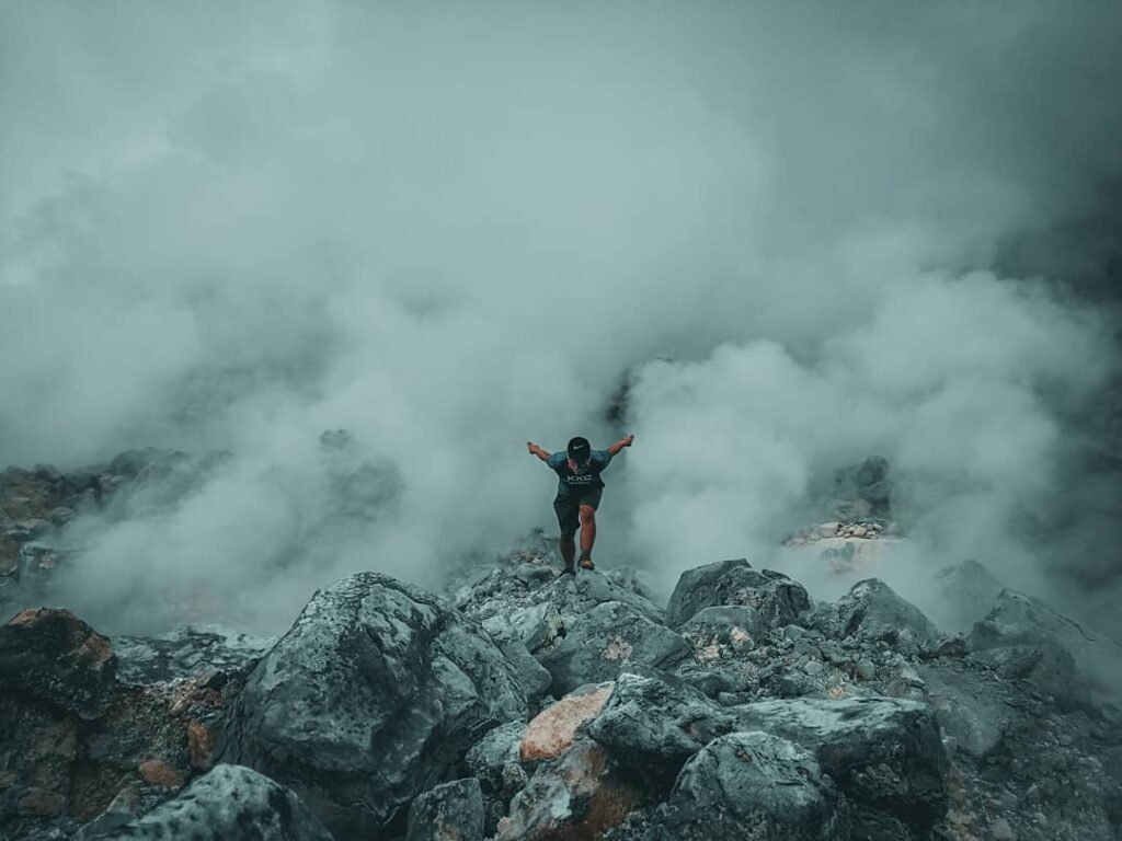
Don’t let the “Minor Climb” tag fool you—I’ve seen experienced hikers underestimate this mountain because of its manageable elevation. While it is rated 4/9 in difficulty, the real challenge here isn’t the altitude; it’s the exposure. The trail is 90% open grassland, meaning you are directly exposed to the sun and the heat index often spikes higher than the actual air temperature.
The terrain is a mix of volcanic soil and jagged andesite rocks. On the Old Trail, you will encounter Class 3 scrambling sections where you need to use your hands for balance, specifically near the Knife Edge. Conversely, the New Trail offers a cardiovascular workout with its endless rolling hills.
Introduction
Mt. Batulao in Nasugbu, Batangas is one of the most accessible “Minor Climbs” near Manila, standing at 811 MASL. Famous for its jagged “Sawtooth” ridge and 12 distinct peaks, it offers a scenic 4 to 6-hour traverse suitable for beginners. This Mt. Batulao DIY Guide covers the essential 2026 updates, including the mandatory guide fees, the Old vs. New Trail loop, and a budget breakdown of approximately ₱1,200 per person.
If you have ever looked out from the Tagaytay Ridge and noticed a jagged, rolling horizon to the west, you have likely seen the silhouette of Mt. Batulao. Unlike the symmetrical cone of Mayon, Batulao is defined by its dramatic “Sawtooth” morphology—a series of 12 peaks formed by millions of years of erosion on this dormant stratovolcano. It is arguably one of the most photogenic horizons in Southern Luzon, offering hikers a front-row seat to the stunning landscapes of the Cavite highlands and Batangas lowlands.
For this Mt. Batulao DIY Guide, we are diving deep into what makes this mountain a timeless favorite. Beyond the views, the mountain holds a geological secret: its name is derived from “Bato sa Ilaw” (Illuminated Rocks). If you hike during the December solstice, you might catch the rare phenomenon where the sun rises precisely between the two highest peaks, bathing the andesite rocks in a brilliant amber glow while the lowlands remain in shadow.
However, don’t let the “Minor Climb” rating fool you. While the trails are established, the open grassland topography means there is zero canopy cover for 90% of the trek. The heat on the open ridges can be brutal, often exceeding the ambient temperature in the lowlands. I’ve seen prepared hikers buckle under the midday sun here, so bringing proper hydration is non-negotiable.
Whether you are gunning for the technical ropes of the Old Trail or the scenic rolling hills of the New Trail, this guide breaks down exactly how to navigate the current local regulations and enjoy the traverse safely.
Pain Point: The most common mistake I see here is hikers bringing insufficient water because they expect an “easy” walk. There are no water sources past Camp 1 or Camp 8, so if you run out midway through the traverse, you are in for a dangerous, dehydrated descent.
If you are looking for other hiking options or side trips in the province, check out our list of 36 Must-Visit Batangas Tourist Spots to plan a full weekend itinerary.
Table of Contents
How to Go to Mt. Batulao from Manila
The most direct way to reach Mt. Batulao is to take a DLTB Co. or BSC bus bound for “Nasugbu” or “Balayan” from the DLTB Buendia Terminal or PITX. The one-way fare ranges from ₱160 to ₱222 depending on the carrier. You must alight at KC Hillcrest (formerly Evercrest Golf Course), NOT the town proper, then take a ₱150 tricycle to the jump-off point.
Option 1: Commute via Public Bus
For backpackers coming from Manila, head to either the DLTB Bus Terminal in Buendia (Taft Avenue) or the Parañaque Integrated Terminal Exchange (PITX). Look for buses with the signboard “Nasugbu” or “Balayan”.
The travel time is usually 2.5 to 3 hours, but I strongly recommend leaving by 3:00 AM to avoid the heavy morning traffic on Aguinaldo Highway.
Important Drop-off Tip: explicitly tell the conductor you are getting off at “Evercrest” or “KC Hillcrest”. Do not just say “Batulao” or “Nasugbu,” as some conductors might mistakenly take you all the way to the Nasugbu Town Proper, which is several kilometers away from the trailhead.
Once you drop off at the highway entrance of KC Hillcrest, you will see a tricycle terminal.
Tricycle Fare: ₱150 per ride (good for 3-4 pax).
Destination: Tell the driver “Jump-off” or “Old/New Trail fork.”
Option 2: Private Vehicle
If you are driving, take the South Luzon Expressway (SLEX) and exit at Santa Rosa or Eton City. Follow the road up to Tagaytay City, then turn right onto the Tagaytay-Nasugbu Highway.
Drive past the Tagaytay ridge restaurants and the Batangas border arch. Keep an eye out for the KC Hillcrest Golf Club entrance on your left side (approx. 15-20 minutes after the border).
If you are planning to explore more of Batangas on your drive back, the new J-Castle in Tanauan is a popular stop for photos, or you could visit the Monte Maria Shrine if you are heading towards Batangas City.
Parking: You cannot drive all the way to the trail start. You must park at the designated areas near the tricycle terminal or inside the Evercrest/Hillcrest compound.
Parking Fee: ₱100 for 4-wheels / ₱50 for motorcycles.
Pain Point: The parking area is an open lot and can get muddy during the rainy season, so ensure your vehicle is secured.
Choosing Your Route: Mt. Batulao Old Trail vs. New Trail
For the complete Mt. Batulao experience, I highly recommend the “Grand Traverse”: Ascend via the technical Old Trail (East) and descend via the scenic New Trail (West). The Old Trail features the adrenaline-pumping “Knife Edge” and rope segments, while the New Trail offers open “rolling hills” perfect for a sunset descent. If you have a fear of heights, stick to the New Trail back-and-forth.
For those who find the technical sections of Batulao too intimidating, you might want to consider the Travel Guide to Mt. Gulugod Baboy, which offers similar sea views but with a much gentler, beginner-friendly terrain.
The Old Trail (East Face): The Technical Route
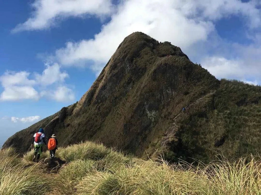
If you crave verticality, this is your playground. The Old Trail cuts through the eastern flank and quickly transitions from a woodland walk to exposed, rocky ridges past Camp 1.
The defining feature here is the “Knife Edge”, a narrow ridge line with steep drops on both sides. The wind here is no joke; during the Amihan season (Nov-Feb), gusts can be strong enough to knock you off balance, so don’t be shy to crouch or “crab walk” if needed.
The final assault to the summit involves near-vertical rock faces equipped with fixed ropes (Class 3 Scrambling). I strongly advise tackling this on the ascent rather than the descent—climbing up these jagged andesite rocks is biomechanically easier and safer than trying to climb down them when your legs are tired.
The New Trail (West Face): The Rolling Hills
The New Trail is deceptive; it looks easier because it lacks vertical cliffs, but the constant up-and-down trek across Peaks 1 through 10 is an endurance test.
This route is famous for its open, grassy ridgelines that look like a “sea of gold” during the dry months. The vibe here is much more relaxed, especially at Camp 8, the mountain’s main campsite. Local vendors often set up shop here, selling fresh Buko Juice (₱50)—a lifesaver after hours of walking under the sun.
Keep an eye out for Janet Belarmino’s Marker, a small structure near the trail owned by the Everest summiteer. It serves as a great mental checkpoint that you are making progress on the rolling terrain.
The Grand Traverse (Old to New Loop)
Why do I recommend the Old to New loop? Two reasons: Safety and Scenery.
Safety: You tackle the high-consequence rope sections on the Old Trail first, when your energy and grip strength are at 100%.
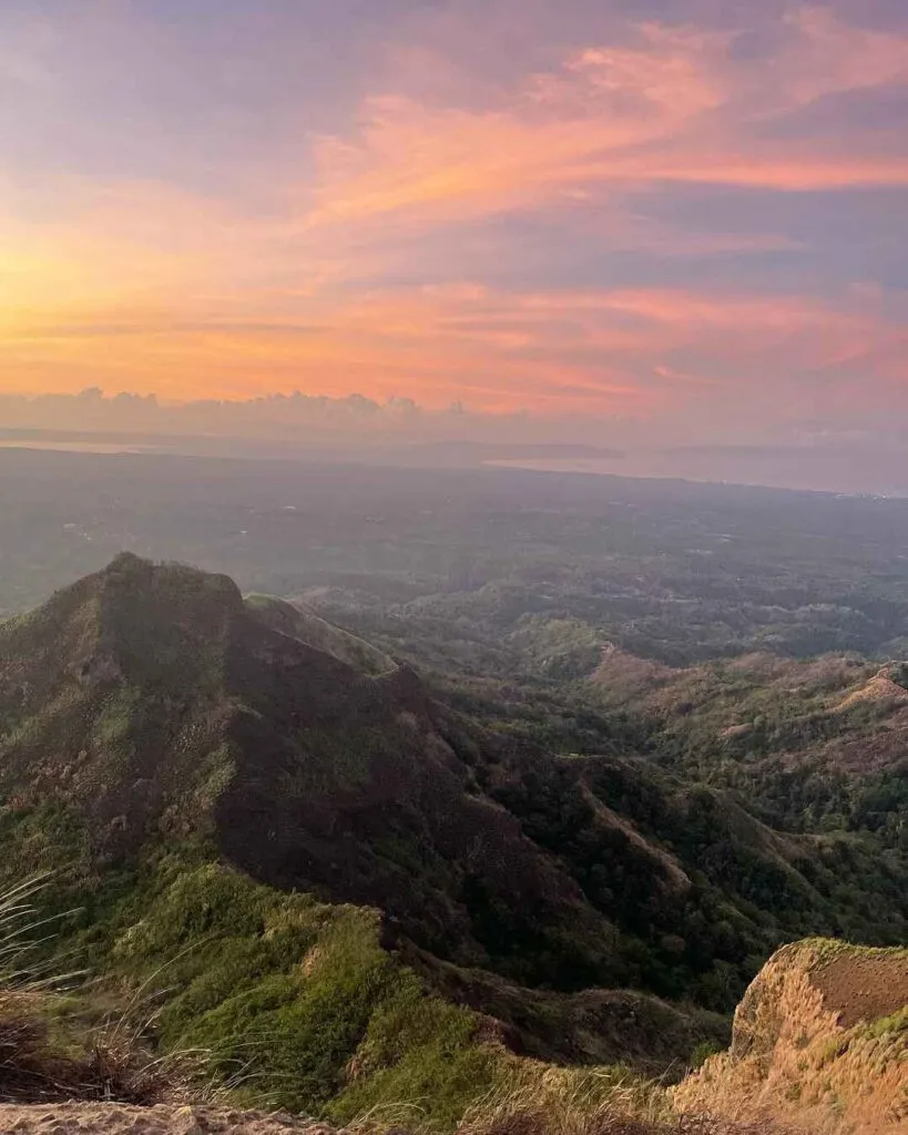
Scenery: Descending the New Trail in the afternoon lets you face the West Philippine Sea, giving you a front-row seat to the sunset (Golden Hour) as you navigate the rolling hills back to the jump-off.
Pain Point: The New Trail descent is dusty and slippery. Even though it’s not “steep,” the dry volcanic soil acts like marbles under your shoes. If you don’t have deep-lugged shoes, expect to slip a few times on the way down.

Mt. Batulao Itinerary (2026)
For a Day Hike Traverse, the ideal strategy is to depart Manila by 3:00 AM to start trekking by 6:30 AM. This timing allows you to clear the exposed Old Trail and reach the summit (811 MASL) before the midday heat peaks at 11:00 AM. A standard pace finishes the loop via the New Trail by 3:00 PM, getting you back to the highway before the evening rush.
The “Grand Traverse” Day Hike
I designed this itinerary based on the Old Trail to New Trail loop. This is critical: you want to tackle the technical rope segments while you are fresh and the sun isn’t scorching yet. If you arrive at KC Hillcrest later than 7:00 AM on a weekend, expect bottlenecks at the rope sections.
Pain Point: The heat on Batulao is punishing. If you start your trek at 9:00 AM, you will be climbing the vertical assaults during the hottest part of the day. I have seen hikers vomit from heat exhaustion here—don’t be that person. Start early.
| Time | Activity | Notes |
| 03:00 AM | Depart DLTB Buendia or PITX | Board bus to “Nasugbu/Balayan” |
| 05:30 AM | Arrival at KC Hillcrest | Alight at Golf Course entrance |
| 06:00 AM | Tricycle to Jump-off | Register & Secure Guide |
| 06:30 AM | Start Trek (Old Trail) | Warm-up walk to the fork |
| 08:30 AM | Arrival at Camp 1 | Pay reg fee (if collected here) |
| 09:30 AM | Knife Edge / Rope Segments | Critical: Secure loose gear |
| 10:30 AM | Summit (Peak 12) | Lunch / 360-degree view |
| 11:30 AM | Descent via New Trail | Steep initial descent |
| 12:30 PM | Rest at Camp 8 | Buy ₱50 Fresh Buko |
| 01:30 PM | Resume Descent | Rolling Hills (Peaks 7-1) |
| 03:00 PM | Back at Jump-off | Shower at local Ligo stations |
| 05:00 PM | Bus to Manila | Dinner in Tagaytay (Optional) |
The “Sunset & Sunrise” Overnight Option
If you want to catch the “Golden Hour” on the cogon grass, an overnight stay is magical. Since you have two days, you don’t need to rush the 3:00 AM bus; you can depart Manila around 10:00 AM.
We prefer camping at Camp 8 (New Trail) because it is spacious, flat, and protected from the fierce ridge winds if you pitch behind the slope.
-
Day 1: Arrive at Jump-off by 2:00 PM. Hike the New Trail carrying your heavy packs (no ropes). Set up camp by 4:30 PM to watch the sunset over the West Philippine Sea.
-
Day 2: Wake up at 5:00 AM. Leave packs in the tent and assault the Summit for sunrise. Break camp and descend by 9:00 AM to beat the heat.
Important: The “Leave No Trace” policy is strictly monitored. I always carry a trash bag because there are no bins at the campsite, and leaving food waste attracts ants and stray dogs.

Mt. Batulao Expenses and Fees
Prepare a budget of approximately ₱1,200 to ₱1,500 per person for a DIY day hike if you are traveling in a group of four. The largest expenses are the mandatory guide fee (₱1,000 – ₱1,500 per group for a traverse) and the roundtrip bus fare from Manila (₱400 – ₱450). Solo hikers should expect to spend significantly more, around ₱2,200, as the guide and tricycle costs cannot be shared.
The “Mandatory Guide” Reality (2026)
I need to manage your expectations: “DIY” no longer means “No Guide.” In the past, we could just hike Batulao freely, but following several accidents and a need to regulate tourism, the local government now strictly enforces a Mandatory Guide Policy.
Don’t view this as a “tourist trap.” The fee directly supports the families in Brgy. Patutong Malaki, many of whom rely solely on guiding for income. When you pay that fee, you are paying for safety on the Knife Edge and contributing to the local micro-economy.
Pain Point: Cash is King. Do not rely on GCash or Maya here. Signal can be spotty at the registration area, and the guides prefer cash payment immediately after the hike. Bring smaller bills (₱20s, ₱50s, ₱100s) for exact change at the “toll gates” or registration booths.
Estimated Budget Breakdown
Here is the breakdown based on my most recent trip. Prices fluctuate slightly depending on the season, but this is a safe baseline.
| Expense Item | Cost (Est.) | Notes |
| Bus Fare (Roundtrip) | ₱400 – ₱450 | DLTB/BSC (Manila <-> Nasugbu) |
| Tricycle Transfer | ₱150 / ride | From Highway to Jump-off (Good for 3-4 pax) |
| Registration / Eco Fee | ₱140 – ₱200 | Composite fee collected at the Barangay outpost |
| Guide Fee (Traverse) | ₱1,000 – ₱1,500 | Per group of 1-5 hikers (Rate is higher for traverse) |
| Shower Use | ₱25 – ₱50 | “Bucket shower” at local houses |
| Safe Budget (Group of 4) | ~₱1,200 each | Sharing the guide and tricycle lowers costs significantly |
| Safe Budget (Solo) | ~₱2,200 | You shoulder the full guide and trike fee alone |
Note: The guide fee for a simple “Backtrail” (New Trail only) is usually cheaper (₱600 – ₱800), but you miss out on the full experience.
What to Bring and Wear
To survive Mt. Batulao comfortably, bring at least 2 to 3 Liters of water per person as the open trail exposes you to intense heat. Wear full-fingered gloves for the sharp volcanic rocks on the Old Trail and use trail running shoes with deep lugs (5mm+) to handle the slippery Batangas clay. Avoid cotton shirts; opt for breathable synthetic or wool base layers.
I cannot stress this enough: Batulao is an “oven” with a view. The combination of direct solar radiation and reflective cogon grass creates a heat index that feels 5–8 degrees hotter than the forecast.
Here is the non-negotiable gear list I use for every Batangas hike:
Gloves (Industrial/Gardening): You will need these for the Old Trail. The rope segments are rough, and the volcanic andesite rocks are sharp enough to slice your palms if you slip. You can buy cheap pairs at hardware stores like Ace Hardware or even at the jump-off (if stock permits), but bringing your own is safer.
Footwear (Deep Lugs Required): Leave your standard running shoes at home. The soil here is “Batangas Clay”—when dry, it’s loose dust; when wet, it becomes slick mud. I wear Salomon Speedcross or Decathlon MH500 boots because you need aggressive, widely spaced lugs to shed the mud.
Sun Protection (Sun Hoodie/Arm Sleeves): 90% of the trail is unshaded grassland. I wear a long-sleeved UPF 50+ sun hoodie to protect against sunburn and cuts from the sharp cogon grass blades.
Hydration System (2-3 Liters): There is no water source at the summit or along the ridge. While you can buy ₱50 Buko Juice at Camp 8, do not rely on it for hydration. Bring electrolyte tablets (like SaltStick or Hydrite) to mix into your water and prevent heat cramps.
Pain Point: Don’t wear white. The red volcanic dust will stain your clothes permanently. After my last hike during the dry season, my socks and shoes turned an unrecoverable shade of rusty orange.
Honest Tips & Warnings for Beginners
Heat exhaustion is the single biggest risk on Mt. Batulao, so I strongly advise starting your hike before 4:00 AM to beat the sun. The open ridges amplify the heat, and the winds on the “Knife Edge” can be gale-force, so secure your caps. If you have a severe fear of heights, the vertical rope sections on the Old Trail might trigger panic attacks.
The “Oven Effect” is Real
Do not underestimate the heat here. Since the trail is 90% open grassland, the light-colored cogon grass reflects sunlight back up at you, creating an “oven effect.” I have recorded heat index spikes of over 42°C on the ridge by 10:00 AM, even when the air temperature was lower.
Pain Point: If you run out of water on the Old Trail ascent, there is no rescue. There are no stores between Camp 1 and the Summit. I once gave my spare water to a dehydrated group who had only brought 500ml bottles—don’t be them.
The Weekend Traffic Jam
If you visit on a Saturday or Sunday, prepare for bottlenecks. The Old Trail has specific “one-way” rope segments where only one person can climb at a time. I have personally waited 30 to 45 minutes clipped onto the side of a rock face just waiting for the queue to move.
If you hate crowds, schedule your hike on a weekday. If you must go on a weekend, be at the jump-off by 5:00 AM sharp to stay ahead of the tour groups arriving in vans.
Dust Bowl vs. Mud Slide
The trail condition changes drastically depending on the season.
Dry Season (Nov – May): The volcanic soil becomes loose and powdery. You will inhale a lot of dust, so bring a tubemask or buff.
Wet Season (June – Oct): The “Batangas Clay” turns into a sticky, slippery mess that clogs shoe lugs instantly. During Habagat, the trail can feel like an ice rink, and I’ve seen hikers slide down the New Trail on their backsides because their shoes lost traction.
Conclusion: Why Mt. Batulao Remains a Classic
Mt. Batulao remains the ultimate training ground for aspiring Filipino mountaineers, offering a perfect mix of technical rope work and scenic ridges for a budget of under ₱1,500. Whether you conquer the “Knife Edge” on the Old Trail or cruise the rolling hills of the New Trail, the key to a safe expedition is a 3:00 AM departure from Manila and strict adherence to the Leave No Trace policy.
For me, Mt. Batulao is more than just a “Instagram mountain”—it is where many of us learned the basics of heat management and scrambling. The 811 MASL elevation might seem modest, but the exposure on the Old Trail teaches you respect for gravity and the elements in a way few other minor climbs can.
Pain Point: The hardest part of this trip isn’t the climb; it’s the traffic on the way back. Expect the Aguinaldo Highway gridlock to add 1-2 hours to your return trip, especially if you leave Nasugbu after 4:00 PM.
If you have extra time or are looking for a post-hike cooldown, why not head straight to the beach? You can check out our Guide to Anilao, Batangas for a relaxing dive, or take a boat to the Greek-inspired ruins covered in our Ultimate Guide to Fortune Island. For those who want something pristine and quieter, the Masasa Beach DIY Travel Itinerary or Little Boracay in Calatagan are excellent options to wash off the mountain dust.
Final Checklist before you go:
[ ] Cash: Withdrew at least ₱2,000 (ATMs are scarce at the jump-off).
[ ] Transport: Checked the DLTB schedule for the first trip (2:00 AM / 3:00 AM).
[ ] Gear: Packed gloves and 2 Liters of water.
Enjoy the “Sea of Gold,” respect the locals in Brgy. Patutong Malaki, and hike safe!
Frequently Asked Questions
Yes, mobile signal (Smart/Globe) is generally strong at the peaks, allowing for social media updates. However, restrooms are limited to basic “bucket-style” facilities at Camp 1 and Camp 8. Hiking without a guide is strictly prohibited by local ordinance, even for solo hikers. Parking is secure at KC Hillcrest or the tricycle terminal for ₱50 to ₱100.
1. Is there a cell signal on Mt. Batulao?
Yes, and it is surprisingly fast. I was able to post Instagram Stories in real-time from Peak 8 and the Summit using both Globe and Smart 5G. However, the signal often drops to “No Service” in the dips between peaks and along the forested start of the Old Trail.
2. Are there restrooms on the trail?
Manage your expectations—comfort rooms here are very basic. There are proper restrooms with running water at the Jump-off points (houses offering “Ligo” for ₱25).
Camp 1 (Old Trail): Has a makeshift latrine, but water is manually hauled.
Camp 8 (New Trail): Has a basic toilet shed, usually for a ₱10-₱20 fee.
Pain Point: Bring your own wet wipes and alcohol; these facilities rarely have soap or tissue.
3. Can I hike solo without a guide?
No. As of 2026, the “No Guide, No Hike” policy is strictly enforced by the barangay tanods stationed at the registration area. Even if you are an experienced mountaineer, you will be turned back or assigned a guide on the spot. This is legally binding under local ordinances in Nasugbu.
4. Is Mt. Batulao safe for kids?
It depends on the trail.
New Trail to Camp 8: Yes, this is generally safe for active kids (ages 7+) as long as they have sun protection.
Old Trail / Summit: Absolutely not recommended for young children. The rope segments and the Knife Edge require an adult’s reach and stability. I have seen parents struggle carrying toddlers over rock faces here—it is dangerous and irresponsible.
5. Where can I park my car?
You have two safe options. Most hikers park at the KC Hillcrest (Evercrest) Entrance or the designated lot near the Tricycle Terminal.
Rate: ₱50 (Motorcycles) / ₱100 (4-Wheels) for day hikes.
Security: The area near the tricycle terminal is manned by locals, so it is generally safe, but do not leave valuables visible inside your car.
Pingback: The Ultimate Guide To The Top 10 Mountains In The Philippine – BizBackLinks
Pingback: Discover the Best Mountains in the Philippines: Your Ultimate Hiking Guide for 2024 – BizBuildBoom